


MAPublisher and Geographic Imager provide an extensive library of predefined coordinate systems available for referencing or transforming mapping projects.
In the United States, the NGS (National Geodetic Survey), a department of NOAA (National Oceanic and Atmospheric Administration) has established a system that divides the United States into 124 zones, each with its own custom projected coordinate system. This system is known as the State Plane Coordinate System. It is important to note that there are two sets of State Plane coordinate systems defined in the United States, one based on the North American Datum of 1927 and the other based on the North American Datum of 1983. In addition to NAD 83, the NAD83 HARN and NSRS2007 adjustments are available for use. All three versions of NAD83 are available in metres, feet or international feet.
State Plane Coorindate Systems projections
There are four projections for SPCS. The geometric direction of each state determines the projection utilized. For states that are longer in the east-west direction, the Lambert Conformal Conic is used. States which are longer in the north-south direction use the Transverse Mercator projection. The panhandle of Alaska, which has the sole distinction of lying at an angle, garners the use of the Oblique Mercator projection, while Guam uses a Polyconic projection.
These coordinates systems are all defined in the MAPublisher and Geographic Imager library, however the initial question “which one do I need to use for my map” cannot be answered by the software itself.
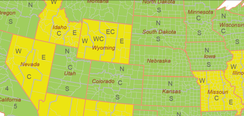
There are a number of ways to determine in which zone your American area of interest lies. One online resource, searchable by latitude and longitude coordinates, can be found on this NGS website.
In an effort to better assist mapmakers in their selection of the appropriate system, the Avenza support team has prepared a searchable interactive map using MAPublisher 8.2 MAP Web Author tool. View the SPCS map here.
A MAPublisher geospatial PDF of the same map is also available for download here.
Transform into State Plane Coorindate Systems using MAPublisher
When it comes time to transform your data into the appropriate State Plane Coordinate System zone, use the MAP View Editor Perform Coordinates System Transformation option. When you specify the destination coordinate system for the transformation, navigate to Coordinate Systems > Projected > North America > United States > US State Plane NAD 83 – on the right hand list, you’ll find all the state plane zones sorted by state name and zone name: select the right one!
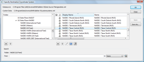
Note: similarly you can select the NAD27 state plane systems from Coordinate Systems > Projected > North America > United States > US State Plane NAD 27 if appropriate.