When purchasing Avenza desktop software, MAPublisher and Geographic Imager, you are able to choose between two main license types: a fixed license or a floating license. This blog will cover the primary differences between the two and hopefully help you determine which setup will work best for you!
Fixed License
Fixed licenses allow for the software to be used on only one computer. This is usually sufficient for most single users or small companies, even with just a few licenses. A fixed license is, as the name suggests, fixed to a specific computer. Consequently, this means that it generally cannot be moved freely to another machine, although Avenza does allow you to move your license occasionally. For example, if you have purchased a new computer or if your main computer is being repaired and you need to transfer your fixed license to another computer. This is called rehosting a license. A license rehost is free as long as you have active maintenance on your license, or can be done for a fee if your maintenance is not active or expired.
Floating License
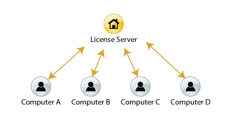
Floating licenses allow an organization to deploy a specific number of licenses that can be used and shared on any number of computers over a network. This is a great solution for any company that has multiple users of MAPublisher or Geographic Imager, especially if all users have their own machine. As such, this means that floating licenses do not need to be rehosted, however there must be a central server from which the licenses are provided to the users within the network. Hence, floating licenses can be further broken down into two categories: cloud floating licenses or local floating licenses.
Cloud Floating License
Cloud floating licenses connect users to their license through the internet. This does not require any additional setup on the organization’s side, and users can access and manage their licenses and servers through a cloud-based customer portal.
Local Floating License
Local floating licenses require a systems administrator at the organization to set up a local server on a computer which meets certain specifications. Only users connected to the local server will be able to check out these licenses on their client computers.
Floating licenses are often the chosen option when an organization would like to share a number of licenses between members. For example, if an organization’s license server holds two seats of MAPublisher licenses, when users on Computer A and Computer B have each checked out MAPublisher licenses, other users on the network are not able to check out a license until the borrowed licenses are checked back in.
Floating licenses also give users the ability to borrow a roaming license with their laptops. This is a good solution for users who want to temporarily use MAPublisher and Geographic Imager when they are not connected to the floating license server.
For more information about the licensing options for Avenza desktop products, please contact Avenza sales. For any technical questions about setting up a license server or any other licensing issues, please contact Avenza support.