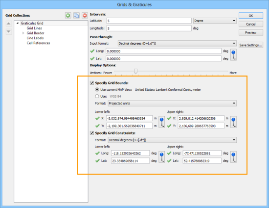
In MAPublisher, the grid bound is the visual extent of the grid or graticule. The grid constraint is the geographic extent of the grid or graticule. It may be a little confusing since both grid bound and grid constraint are defined by coordinate values. In terms of hierarchy, think of the grid bound as the overall container of the grid and the constraint as being contained within the bound.
These examples may help you better understand it.
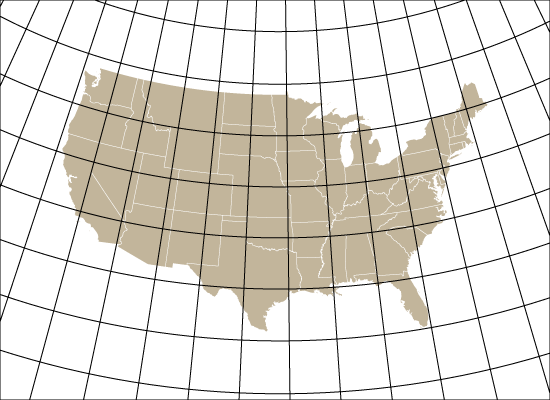
1. In this example, the grid bounds are specified as the lower-left and upper-right of the artboard corners. Notice that the graticule extends all the way to the edge of the artboard (as specified). This is a very typical way to use a grid or graticule.
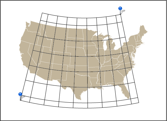
2. Here, the grid bounds are still the lower-left and upper-right of the artboard. The grid constraint is based on the minimum and maximum longitude and latitude values of the specified MAP Locations. Notice that the rectangular black border of the grid bound is at the edge of the artboard. This is also a common way to use a grid or graticule, especially for larger scale maps.
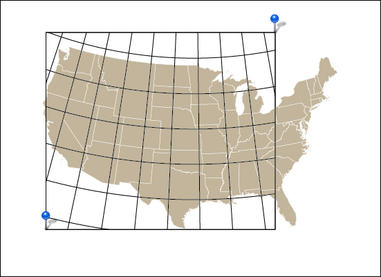
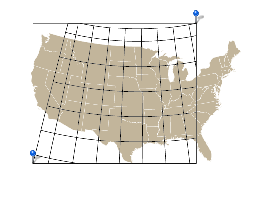
3. In this example, the grid constraints were disabled and, instead, the two MAP Locations are used to define the grid bounds. Notice that the rectangular black border of the grid bound is defined by two MAP Locations.
4. When both grid bound and grid constraint are set to the same coordinates (in this case, MAP Locations) you can see the result here. The grid bounds are clipping the grid constraints. This would not be an ideal situation to use grid constraints, but it is definitely possible to use it in this fashion.
MAPublisher Grids & Graticules are highly customizable and we’ll be blogging more about its features.
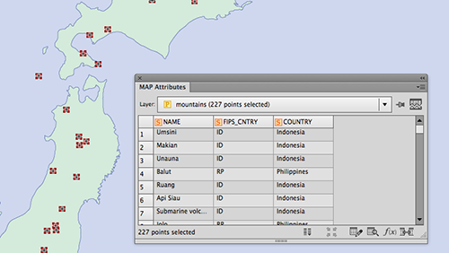
Have you ever had a point dataset where you wanted to obtain the elevation information for every point?
Instead of looking up another dataset to join elevation values or worse, looking them up by hand, MAPublisher 9.3 introduced a new feature to determine the elevation value for every point in a MAP Point layer using the “Add Calculate Data” tool. . This is based on using a GeoName account (more on this below).
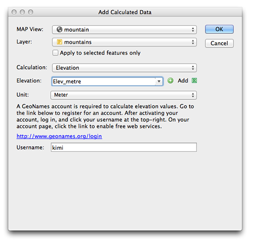
To use it, simply have a MAP Point layer imported to the artboard and open the Add Calculate Data dialog box. In this example, we’re trying to gather elevation points for mountains in Japan. In the Calculation drop-down list, choose Elevation. You can choose the units for the elevation value from the drop-down list. For this example, we are choosing “meter”. If you do not have the GeoName account yet, click the hyperlink and obtain one (for free). After you’ve registered for a GeoName account, enter your username and click “OK”.
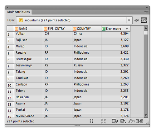
A new column “Elev_metre” is populated as specified in the Add Calculated Data dialog window and every point has the elevation information in meters.
This is a handy tool that may help when you have point data along hiking trails, ski courses, waypoints collected with PDF Maps (etc.) or when you need to find elevation data for any type of points.
If you use this feature, please send us your feedback and tell us how you like it!
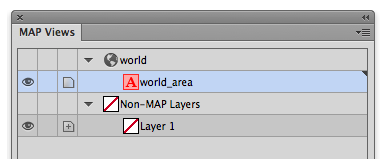
Do you have some data you would like to divide into multiple layers using unique values in an attribute? If so, you might want to try using the Split Layer feature in MAPublisher.
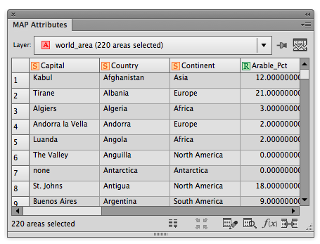
For example, we have a MAP Layer of the world (world_area layer). The world_area layer has many attributes and one of the attributes is about “Continent” information. With the “Continent” attribute, there are eight unique values: 1) Africa, 2) Antarctica, 3) Asia, 4) Australia, 5) Europe, 6) North America, 7) Oceania, and 8) South America.
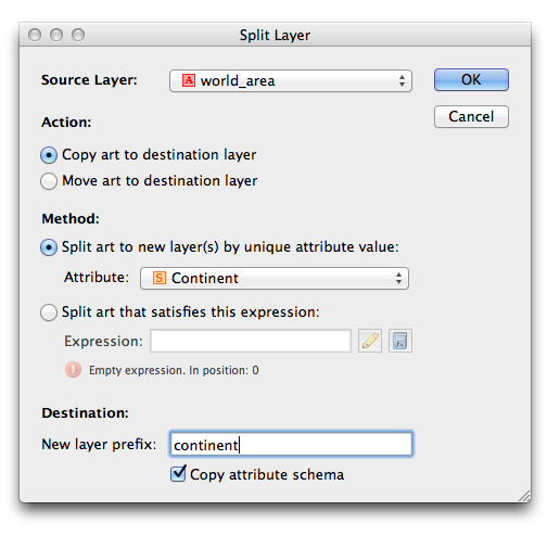
To split this world_area layer into eight different layers based on unique values in the “Continent” attribute, we simply specify the Continent layer in the Split Layer dialog box.
Open the Split Layer dialog box. Choose the world_area source layer, then select the option “Split art to new layer(s) by unique attribute value:”. If you have a specific word you would like to include with the eight layers, enter the value for the “New layer prefix” option. Here, we entered the word “continent” as the prefix.
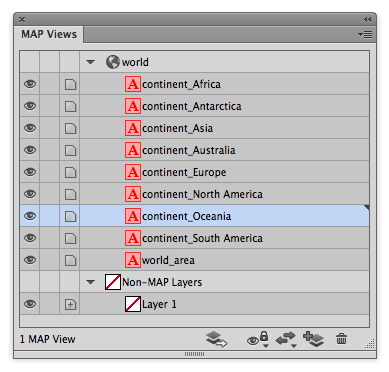
Now you have eight new MAP layers created based on the unique values of the “Continent” attribute. The attribute scheme, structure, and attribute values are inherited from the source layer to the split layers.
Connect to ArcGIS Online within Adobe Illustrator to import and work with data layers
Toronto, ON, January 4, 2017 – Avenza Systems Inc., producers of the Avenza Maps app for mobile devices and geospatial plug-ins for Adobe Creative Cloud, including Geographic Imager® for Adobe Photoshop®, is pleased to announce the highly anticipated integration of ArcGIS Online into the latest release of MAPublisher 9.9 for Adobe Illustrator.
Map makers and GIS professionals can sign-in to their ArcGIS Online account, view available data layers, and import them directly into Adobe Illustrator, while maintaining all georeferencing, geospatial features, and attributes. Unlike Esri’s recent ArcGIS for Adobe Creative Cloud offering, MAPublisher maintains a true GIS-like operating environment within Adobe Illustrator and does not drop attributes or geodata. In addition, users can connect to ArcGIS web services, providing the flexibility to import data from a wide variety of sources. ArcGIS Online is also included in the MAPublisher Point Plotter tool as an option to geocode addresses (using ArcGIS Online service credits).
“MAPublisher is evolving with the integration of ArcGIS Online,” said Ted Florence, President of Avenza. “We’re committed to providing professionals with more options to get data into Adobe Illustrator using MAPublisher so that can they make the best map products possible,” he added. “From start to finish, MAPublisher makes it easy for anyone to add geospatial data from a variety of sources, create maps with intuitive mapping tools and publish maps to print, web, and mobile-ready formats.”
More about MAPublisher for Adobe Illustrator
MAPublisher for Adobe Illustrator is powerful map production software for creating high-quality maps from GIS data. MAPublisher cartographic tools leverage the superior graphic design capabilities of Adobe Illustrator to manipulate GIS data and to produce both print-ready and online maps with accuracy and efficiency.
MAPublisher 9.9 is currently available starting at US$1399 for a commercial fixed license. MAPublisher FME Auto and MAPublisher LabelPro are also available as add-ons starting at US$399 per license. Floating and volume pricing are also available. Prices include one year of full maintenance. Visit www.avenza.com/mapublisher for more details.
More about Avenza Systems Inc.
Avenza Systems Inc. is an award-winning, privately held corporation that provides cartographers and GIS professionals with powerful software tools to make better maps. In addition to software offerings for Mac and Windows users, Avenza offers value-added data sets, product training and consulting services, as well as the Avenza Maps app for purchasing and using maps on iOS, Android, and Windows devices. Visit www.avenza.com for more details.
For further information contact:
416-487-5116
info@avenza.com www.avenza.com
The 28th International Cartographic Conference will take place in Washington, D.C., USA, July 2-7, 2017.
Avenza will be participating as an exhibitor at the conference. Avenza product specialists will be available to discuss how Avenza Maps technology is changing the cartography industry and how MAPublisher and Geographic Imager desktop mapping solutions can be a great fit for your organization. Come visit us in booth #422
Location:
Marriott Wardman Park Hotel
2660 Woodley Road NW
Washington, District Of Columbia 20008
USA
More about the International Cartographic Conference
The Cartography and Geographic Information Society (CAGIS) invites the world of cartography and GIS to come to Washington, DC, July 2 to 7, 2017 for the 28th International Cartographic Conference of the International Cartographic Association. We are planning a fantastic conference that will draw upon all the resources of the nation’s capital. The National Galleries of Art, the Smithsonian Institution, the National Geographic Society, and the Library of Congress will all play a role in making this a great conference.
The 2017 Canada North Resources Expo is a showcase of the resources sectors’ leading companies and products.
Avenza will be participating as an exhibitor at the expo and product specialists will be available to discuss how Avenza Maps mobile technology is changing the cartography industry and how MAPublisher and Geographic Imager desktop mapping solutions can be a great fit for your organization. Come visit us in booth #321
Whether you’re new to MAPublisher®, an experienced user, or simply thinking about a purchase, Avenza software training is a worthwhile experience. Get hands-on training from Avenza product specialists at one of our training courses around North America.
Who should attend?
GIS professionals who want to produce better quality maps
Map makers and cartographers incorporating GIS data to improve accuracy in their maps
New MAPublisher users who just purchased a license
Users who want to experience the latest features of MAPublisher
Cost
Cost of the two-day training course is $1,000 USD per person. Discounts are available to groups of three or more from the same organization and for returning students desiring a refresher or update. Major credit cards are accepted.
Training details
Hands-on training takes place at a training center classroom where Windows computers and all required software and training data are provided.
Attendees will learn the fundamentals of MAPublisher and learn how to use all major features. Attendees will also receive basic instruction on the use of Adobe Illustrator as it relates to MAPublisher and cartographic production. A basic knowledge of Adobe Illustrator is recommended, but not required.
Attendees are encouraged to bring his or her own datasets. There will be some time during the end of the course to discuss these with an instructor.
Attendees that are Mac users may opt to bring his or her own Mac and software. Make sure to inform Avenza a week before training to setup the system properly for training.
Classes may be cancelled up to seven business days prior to the confirmed training date (depending on the number of reservations received).
The AAG 2017 Annual Meeting will take place April 5 – 9, 2017 in Boston, MA at the Hynes Convention Center, Marriott Copley Place and the Sheraton Boston.
Avenza will be participating in the conference exhibition and trade show, in booth #408, during which Avenza product specialists will demonstrate and discuss MAPublisher, Geographic Imager and the Avenza Maps app. This is a great time to see Avenza products in action and to have all your product-related and workflow questions answered. It will also be an opportunity to see upcoming features and functionality of future releases.
For more details or to book an appointment call 416-487-5116 or email Avenza.
About the AAG Annual Meeting
The AAG Annual Meeting is an interdisciplinary forum open to anyone with an interest in geography and related disciplines. Presentations from scholars, researchers, professionals, and students are welcome. The five-day conference will host more than 7,000 geographers from around the world and feature over 5,000 presentations, posters, workshops, and field trips by leading scholars, experts, and researchers. Sessions will be organized around many subfields, special tracks, and featured themes. For more information, visit www.aag.org/cs/annualmeeting.
ArcGIS Online integration and CC 2017 compatibility
Toronto, ON, December 15, 2016 – Avenza Systems Inc., producers of the Avenza Maps app for mobile devices and geospatial plug-ins for Adobe Creative Cloud, including Geographic Imager® for Adobe Photoshop®, is pleased to announce the release of MAPublisher 9.9 for Adobe Illustrator. This latest update includes many new features including full compatibility with Adobe Illustrator Creative Cloud 2017.
This MAPublisher release also introduces the ability to import geospatial features and attributes directly from ArcGIS Online into Adobe Illustrator enabling users to harness MAPublisher’s mapping tools to create georeferenced and feature-rich maps from ArcGIS Online data sources.
Several new geoprocessing tools including the MAP Trim and MAP Extend tools are also included in this release.
“We’re pleased to release MAPublisher 9.9 with full compatibility for the latest Adobe Illustrator CC 2017 update,” said Ted Florence, President of Avenza. “We’ve been working hard to stay in sync with the regular updates of the Creative Cloud platform.”
“The ArcGIS Online integration is a very exciting addition to MAPublisher,” said Doug Smith, Director of Sales at Avenza. “Our users have asked about easier ways to import their GIS data and we’ve committed to providing them with a new way of doing so,” he added. “MAPublisher is full-featured from start to finish and anyone can begin with raw data, use dynamic mapping tools, and deliver print-ready maps as well as digital maps for use on mobile and web platforms.”
Enhancements and new features of MAPublisher 9.9
Fully compatible with Adobe Illustrator Creative Cloud 2017 on both Windows and macOS
Sign-in and import Feature Layers, Map Image Layers, Tile Layers, and web services from ArcGIS Online and ArcGIS Server hosts
Geocode addresses with ArcGIS Online using MAP Point Plotter
Use the MAP Trim Tool to quickly trim lines to a specified line
Use the MAP Extend Tool to quickly extend lines that intersect another line
A text utility that adds specified line breaks based on words or characters per line
More about MAPublisher for Adobe Illustrator
MAPublisher for Adobe Illustrator is powerful map production software for creating high-quality maps from GIS data. MAPublisher cartographic tools leverage the superior graphic design capabilities of Adobe Illustrator to manipulate GIS data and to produce both print-ready and online maps with accuracy and efficiency.
MAPublisher 9.9 is available free of charge to all MAPublisher users with an active maintenance subscription and as an upgrade for non-maintenance users starting at US$599. New commercial licenses are available from US$1399. MAPublisher FME Auto and MAPublisher LabelPro are also available as add-ons starting at US$399 per license. Floating and volume pricing are also available. Prices include one year of full maintenance. Visit www.avenza.com/mapublisher for more details.
More about Avenza Systems Inc.
Avenza Systems Inc. is an award-winning, privately held corporation that provides cartographers and GIS professionals with powerful software tools to make better maps. In addition to software offerings for Mac and Windows users, Avenza offers value-added data sets, product training and consulting services, as well as the Avenza Maps app for purchasing and using maps on iOS, Android, and Windows devices. Visit www.avenza.com for more details.
For further information contact:
Tel: 416-487-5116
Email: info@avenza.com
Web: www.avenza.com
New Pro subscription makes it easier for businesses and organizations to adopt and deploy the popular mobile application
TORONTO (November 15, 2016)— Avenza Systems Inc., producers of MAPublisher® cartographic software for Adobe® Illustrator® and Geographic Imager® geospatial tools for Adobe Photoshop®, has announced that its market-leading, award-winning mobile mapping app, Avenza Maps, will now have a Pro version available immediately. Avenza Maps Pro is a cost-effective annual subscription designed to meet the needs of professionals of businesses, government agencies, and educational institutions.
Avenza Maps Pro is the most powerful version to date of this popular and widely-used application and benefits from years of development and commitment to the mapping community. Features of the Pro subscription include commercial, government and other professional use rights (not available with other versions), allowing unlimited number of maps to be imported, Shapefile import and export, data collection and management, and enhanced support. The subscription also allows for enterprise-level management of the Avenza Maps app across mobile devices for organizations of any size using a new subscription management system.
“Avenza Maps Pro is a large part of our rebrand strategy,” said Ted Florence, President of Avenza Systems Inc. “The Avenza Maps Pro subscription is a logical step towards better serving our professional users. With a free version serving as a base for consumers and enthusiasts and a Pro subscription upgrade available to professionals, we now have an app and platform that can cater to these distinctly separate markets. Moving forward, we have plans to improve how we take care of both markets with clearer brand marketing approaches,” he added.
“Building Avenza Maps Pro is a testament to how popular the app is among professional users,” said Doug Smith, Sales Director of Avenza Systems Inc. “We have plans to build out additional professional features to increase the value proposition of Avenza Maps to the professional community.”
The Avenza Maps app is an all-inclusive mapping platform for iOS, Android, and Windows mobile devices. Consumers can download the app for free, get georeferenced maps from the Avenza Map Store, and use them completely offline with a variety of tools. Map publishers can register as a vendor in the Avenza Map Store and generate revenue by pricing their maps and making them available for purchase. Businesses and organizations can upgrade to a cost-effective Avenza Maps Pro subscription which allows for commercial use, includes enhanced tools and features, and enhanced support. For more information, visit the Avenza Maps website at www.avenzamaps.com.
About Avenza Systems Inc.
Avenza Systems Inc. is an award-winning, privately held corporation that provides cartographers and GIS professionals with powerful software tools for making better maps as well as the Avenza Maps mobile mapping platform. In addition to software offerings for Mac and Windows users, Avenza offers value-added data sets, product training, and consulting services. For more information, visit the Avenza website at www.avenza.com.