We’re excited to announce that we’ve released MAPublisher 10.1 for Adobe Illustrator. The MAPublisher product team has been working closely with our customers to build these features to improve map design productivity.
MAPublisher 10.1
This update contains new features and performance improvements as well as fixes for reported bugs. Some highlights are mentioned below, for the full release notes see below.
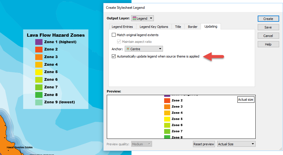
Automatically update existing legends when MAP Themes are modified. It’s here! MAP Theme legends are can now be automatically updated when legend items are updated in a theme. This is great time saver when you’re in the fine-tuning phase of selecting the right colour palette for your map and there is no need to manually update your legend.
New ability to create lines from text on a path. Creates a line based on a text on a path source. It’s useful for creating map features and to assist in indexing for manually created maps (i.e. scenarios where text was created manually instead of being created from attribute values). The text utility can be applied to text on a specific layer, on a specific MAP View, on the entire document or only selected text.
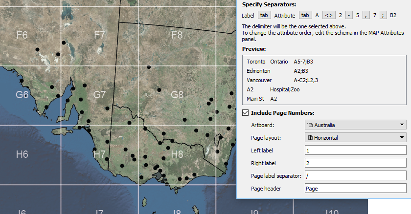
New ability to include page numbers when creating indexes. In the Make Index tool, a new Include Page Numbers option provides the ability to split a single artboard (horizontally or vertically) at the middle point to make indexes that include a reference to a page (left or right, top or bottom). This feature is useful when a map spreads over a single artboard that is intended to be split into two pages in a final output (e.g. a spread in an atlas). Text and features that span both “pages” can be listed in the index as appearing on both pages (i.e. indexing the extents of the text or feature).
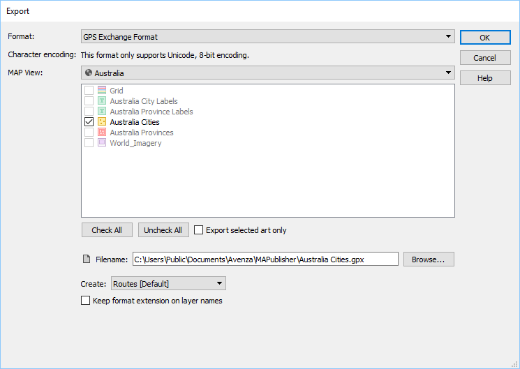
Export to GPS Exchange format (GPX) now supported. MAPublisher has long supported GPX import and now supports GPX export. It’s a format that contains contain tracks, routes and points and used to exchange data between GPS units and mapping software. It is compatible with the Avenza Maps app and many other third-party applications.
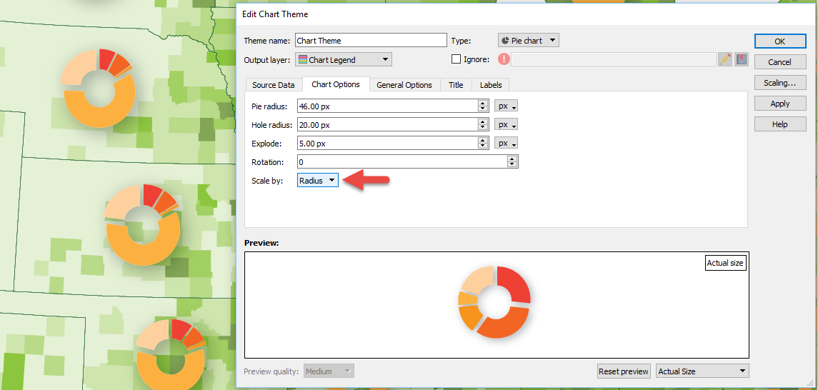
New ability to scale charts by radius. You now have the ability to scale MAP Chart Theme pie charts by radius, in addition to the existing method of using area. This provides another level of fine-tuning while adjusting charts to get proportional scaling correct. Remember that there are advanced scaling features available in the Scaling dialog box (just click the Scaling button). Learn more about chart scaling here.
MAPublisher 10.1 Release Notes
Automatically update existing legends when MAP Themes are modified
New ability to create lines from text on a path
New ability to include page numbers when creating indexes
Export to GPS Exchange format (GPX) now supported
New ability to scale charts by radius
A number of user interface and usability enhancements.
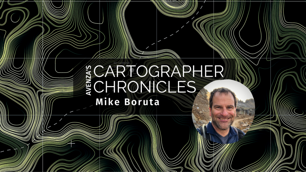
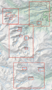
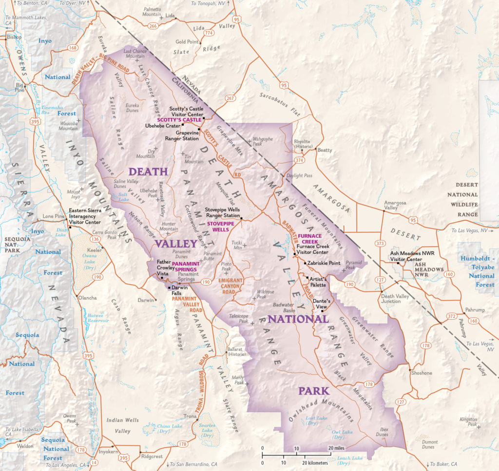
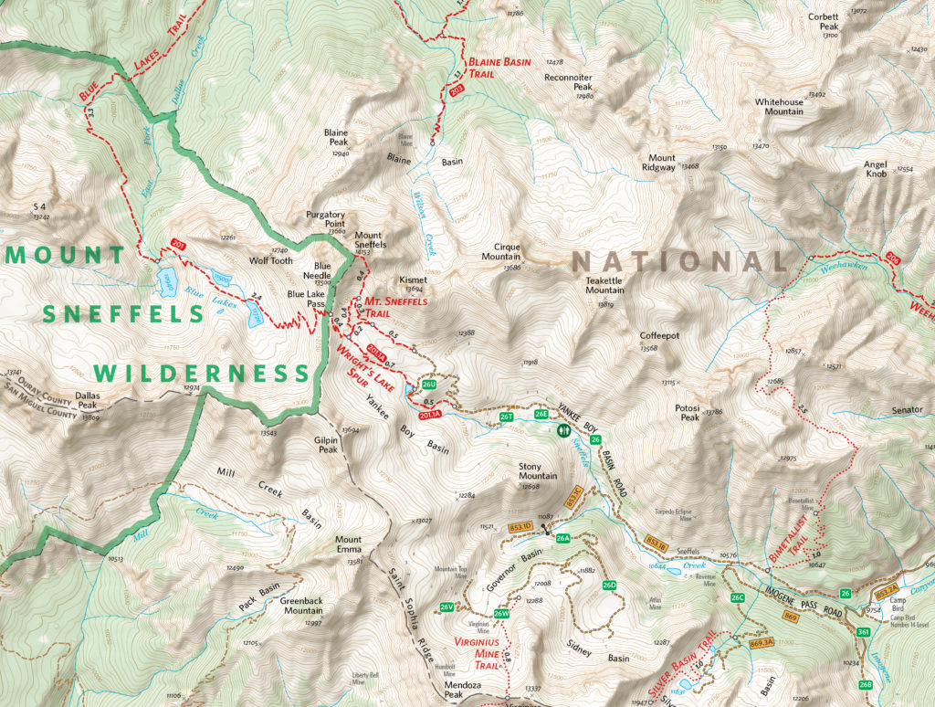
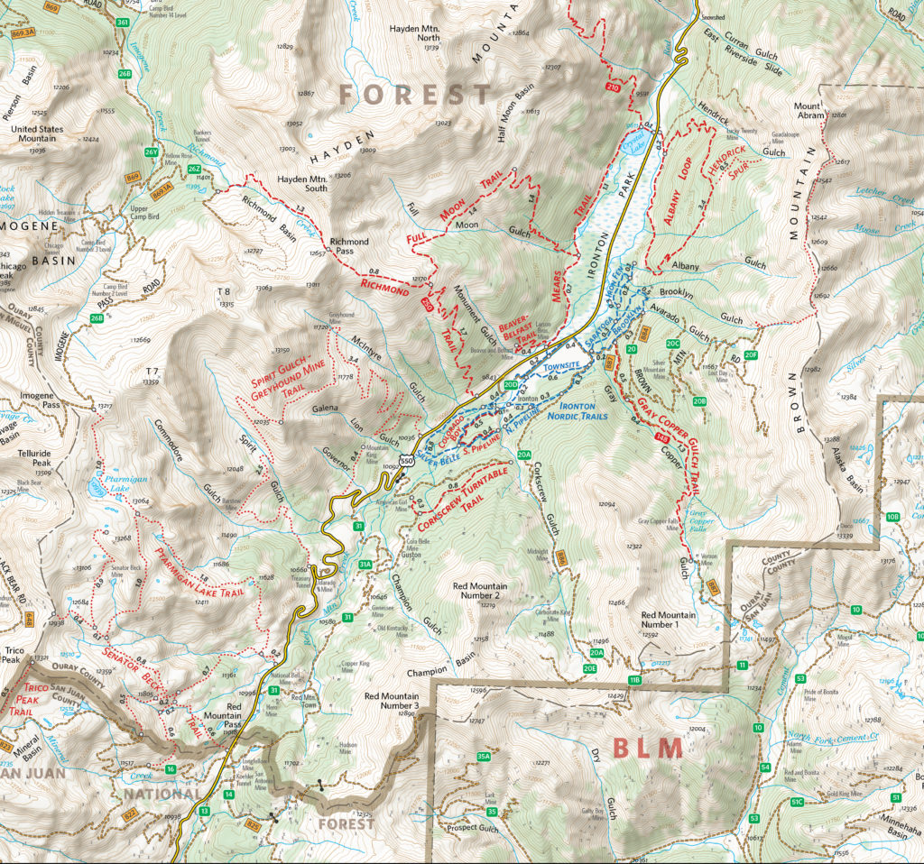
Colorado-based cartographer Mike Boruta knows a thing or two about making maps. In fact, this award-winning cartographer has been designing spectacular maps and trail guides for more than a decade. His work can be seen in the National Geographic Trails Illustrated series, in mountain biking guides released by Fixed Pin Publishing, fly-fishing reference maps curated by Stonefly Press, or most recently in the hiking trails guide for the mountainous town of Ouray, Colorado, where he currently lives. Always fascinated with viewing the world from above, Boruta has dedicated his career to capturing the beauty of mountain landscapes through well-designed maps, and captivating cartographic styles.
Following several years of post-university travel, Boruta found himself living in the tiny tourist-driven town of Ouray. Seeking more opportunities for career advancement, he moved to Arcata, located on the north-western coast of California. He considered returning to school to pursue a computer science degree but realized the subject matter did not entirely excite him. That was when a coworker of his first told him about the excellent Geography and Cartography programs at Humboldt State University nearby. He learned about a subject-stream called Geographic Information Systems (GIS), and although having never heard of GIS before, the concept immediately interested him. His years of travel had given him quite an appreciation for maps, and the GIS and Cartography programs at HSU would allow him to combine this appreciation with an interest in computer technology.
He quickly developed a passion for cartography and decided to pursue graduate schooling in Athens (OH), where he studied under established cartographer Dr. Margaret Pearce. Forever drawn back to the rugged mountain landscapes where he had lived in the past, Boruta found a particular interest in studying relief representation in cartography, the technique used to create the illusion of 3D-terrain on a 2D map. He fell in love with the work of renowned Austrian cartographer Heinrich Berann, whose painterly style “birdseye” mountain maps continue to inspire him today.
“Anytime I had to choose a place to use for projects in my cartography or GIS classes I found myself pulled back West, usually to Ouray, Colorado. I grew increasingly interested in mapping mountainous places”
In 2009, Mike Boruta first began using Avenza MAPublisher in his work. He had recently won the Arthur Robinson Award for Best Printed Map, part of the CaGIS Map Design Competition, for his entry “The Million Dollar Highway”, which explored a scenic stretch of road connecting Ouray to Silverton, Colorado. The award included a student license for Avenza MAPublisher software and allowed him to seamlessly integrate its suite of cartography tools into his already Adobe Illustrator-heavy mapping workflows. Shortly after, he began working with the publishing company Fixed Pin to create a mountain-biking guidebook for the entire state of Colorado. The project was extensive and would require the creation of several complete and detailed map sets, each describing a unique part of the state. Recognizing the vast scale of work ahead of him, Boruta sought out mapping solutions that would help him enhance the efficiency of his cartographic workflow.
“This was the first time I really got to work with MAPublisher, and it was a joy to learn and to use. I immediately found out how useful it was to set up all my graphic styles and character styles since I was having to create 118 maps with the same look and feel.”
As Boruta found himself less and less dependent on dedicated GIS software, he opted to focus on completing his projects from start to finish directly in Adobe Illustrator using the many data import and manipulation tools of MAPublisher. This environment, he felt, “lent itself to so much more creativity”. Integrating these mapping tools into his workflow also meant he did not have to continuously replicate shared design features between each map, instead organizing and stylizing his data into a series of 15 “master maps” and using the MAPublisher Vector Crop tool to create separate individual maps for specific regions.
By 2011, Boruta had begun contract work with National Geographic to help produce maps for the Trails Illustrated line of topographic map products. Incredibly, in 2013 things aligned in such a way that he was able to once again move back to Ouray, the mountain-town he had fallen in love with many years earlier. There, he began meeting with the volunteer-run Ouray Trail Group (OTG) to discuss how he could help them improve their existing trail map, which is a major source of funding for the non-profit group. The first project was getting their map into the Avenza Map Store so that hikers could use the map on their phones and tablets. After that, it was clear that the newly created and extremely popular hiking route called the “Ouray Perimeter Trail” needed its own high-quality map.
Finding some free time in the summer of 2020, Boruta dedicated himself to fully revising the Ouray Trail Group’s main trail map and also creating an all-new map for the Ouray Perimeter Trail. His vision included a highly-detailed, topographic map showing the entirety of the county’s vast trail system. He set to work collecting datasets and planning the map production, first using dedicated GIS software, before reverting to a more design-focused workflow in Illustrator.
“I quickly moved things into Illustrator and MAPublisher and never looked back. There are certain tasks I’ve grown used to doing in MAPublisher that I just find so much faster and simpler to do than if I were in ArcGIS or QGIS”.
As is common with many mapping workflows, working from mixed data sources can be a constant challenge for many cartographers, especially when data from different public agencies do not share the same projection and coordinate systems. Boruta found this to be a common occurrence while working on his OTG trail maps and highlighted his fondness for being able to drag and drop data into different Map Views directly within Illustrator. In this way, he allowed the software to automatically reproject datasets to a shared projection without having to open up any sort of tool or repeatedly configure data parameters.
Boruta also emphasized how powerful the Vector Crop tools and “spatial filter on import” capabilities were, allowing him to quickly specify or delineate a region of interest and immediately crop all data layers to that area, retaining topology and attribute integrity, all within the Illustrator environment. When handling the reference maps used to guide the creation of the OTG trail maps, he implemented the Georeferencing tools in the Avenza Geographic Imager plug-in for Adobe Photoshop to efficiently georeference and georectify unprojected reference map images before integrating them back into his Illustrator project. After a large chunk of the summer working on the map, he delivered the finished trail map. On completing the project, he noted “It was one of the most satisfying projects I’ve ever worked on since I was literally mapping my own beloved backyard.”
The completed Hiking Trails of Ouray County and the Uncompahgre Wilderness map is available in printed form, and users can also purchase digital forms of that map and the new Ouray Perimeter Trail Map in the Avenza Map Store. The digital maps are fully geo-enabled and support offline use for navigation and GPS-location on mobile devices using the Avenza Maps app.
Mike Boruta still lives in his beloved town of Ouray. He spends his free time enjoying the trails and mountains which he has helped to map. He continues his work for National Geographic and has branched out his interests to include drone photography and videography. He operates the website OuraybyFlight.com, which showcases some of his spectacular drone photography work. His dream is to combine these dramatic landscape panoramas with overlaid symbols and text to create those iconic “birdseye” mountain maps that inspired him years ago.
“I envision something that would hopefully be more aesthetically pleasing, something that aims to capture the soul of these San Juan Mountains while also illustrating the geography. And just maybe it might also be something pretty enough to hang on the wall.”
February 27 – March 1, 2018 Peppermill Resort & Spa – Reno, NV
The Avenza team will be on hand in booth #319 to provide conference attendees with demonstrations of the Avenza Maps app and how it can be used in fire, rescue, safety, and emergency response situations. Exhibit hours are 4:30 PM – 6:30 PM on Tuesday and 10:00 AM – 2:00 PM on Wednesday
About Wildland URBAN Interface 2018
The IAFC’s Wildland-Urban Interface (WUI) conference offers hands-on training and interactive sessions designed to address the challenges of wildland fire. If you are one of the many people responsible for protecting local forests or educating landowners and your community about the importance of land management—then this is the conference for you.
Avenza will be participating at the Igniting Exchange meeting and will be available to discuss how Avenza Maps technology is helping in fire science and management. In addition, Avenza will be on hand to discuss how MAPublisher and Geographic Imager desktop can be mapping solutions for your organization.
About Igniting Exchange
The Northeast Forest Fire Protection Compact and the North Atlantic Fire Science Exchange are holding a partners meeting, Igniting Exchange: Bridging the Gap between Science and Management. A true EXCHANGE is designed to expose fire managers to useful scientific studies and expose scientists to the implications of their science.
More than 10,000 maps for public consumers and 26,000 maps for intelligence community
Toronto, ON, January 10, 2018 – Avenza Systems Inc., producers of MAPublisher® cartographic software for Adobe® Illustrator® and Geographic Imager® geospatial tools for Adobe Photoshop®, announces the official release of more than 36,000 maps by LAND INFO Worldwide Mapping, LLC on the Avenza Map Store, exclusively for use in Avenza Maps®, its market-leading, award-winning mobile mapping app.
Avenza Systems and LAND INFO, a leading provider of global digital topographic map data, satellite imagery and value-added remote sensing solutions including advanced Object Based Image Analysis, have partnered to bring more than 10,000 maps to public consumers and 26,000 additional maps exclusively to Avenza Maps for GEOINT users. The GEOINT App Store, developed by the United States National Geospatial-Intelligence Agency (NGA), makes the Avenza Maps app available to Department of Defense (DoD) and Intelligence Community (IC) personnel.
Avenza Systems President, Ted Florence, comments, “With this release of LAND INFO maps for our users, Avenza confirms its position as a global leader in supporting those who use offline maps for everything from outdoor recreation to tactical military operations.” Nick Hubing, President of LAND INFO, adds, “Our map datasets have traditionally only been available to professional GIS users. As the industry-leading app, Avenza Maps was by far the best path to make our content available to both consumers and professional users needing fast and easy access to mapping in mobile devices.”
Public consumers have access to maps from more than 25 countries, some with 50k, 100k, 200k, and 250k map scales. GEOINT users will have access to maps from more than 100 countries, some with map scales as detailed as 10k and 25k, including several city level maps.
LAND INFO maps are each priced at $3.99 USD and are now available on the Avenza Map Store. GEOINT users have unlimited access to the Avenza Maps Store and downloads without any cost to the user. Additional bundled map sets will be available shortly. The partnership with LAND INFO adds another high-level procurement resource to Avenza Maps. Inquire about additional available data for areas of interest not yet covered.
More about Avenza Maps and Avenza Systems Inc.
The Avenza Maps app is an all-inclusive mapping platform for mobile devices. Users can import and use maps offline in addition to getting maps from the Avenza Map Store. Map publishers can become Avenza Map Store vendors and make their maps available for purchase. Businesses and organizations can upgrade to an Avenza Maps Pro subscription which allows for commercial use, includes enhanced tools and features, and enhanced support. For more information, visit www.avenzamaps.com.
Avenza Systems Inc. is an award-winning, privately held corporation that provides cartographers and GIS professionals with powerful software tools to make better maps. In addition to software offerings for Mac and Windows desktop users and iOS and Android mobile users, Avenza offers value-added data sets, product training and consulting services. Visit www.avenza.com for more details.
For further information, contact:
416-487-5116
info@avenza.com
www.avenza.com
Toronto, ON, January 4, 2018 – Avenza Systems Inc., producers of the Avenza Maps® app for mobile devices and geospatial plug-ins for Adobe Creative Cloud, including MAPublisher® for Adobe Illustrator®, is pleased to announce the release of Geographic Imager® 5.3 for Adobe Photoshop®. This latest update includes many new features including full compatibility with the latest Adobe Photoshop Creative Cloud 2018 release.
Geographic Imager 5.3 also introduces Adobe Photoshop resampling methods in several Geographic Imager tools that include a resampling option for improved image results. Input and display precision controls can now be easily customized to reveal much higher precision values.
“Geographic Imager and MAPublisher are now both fully compatible with Adobe CC 2018,” said Ted Florence, President of Avenza. “We love the feedback from our users about the ability to work with both products in an ideal map production environment,” he added.
Enhancements and new features of Geographic Imager 5.3
Fully compatible with Adobe Photoshop CC 2018 on both Windows and Mac
Fully compatible with macOS 10.13
Adobe Photoshop resampling methods now available for tools that include a resampling option
Input and display precision controls are now separately controlled in Preferences
Advanced export options for specifying BigTIFF or DEM TIFF block size
More about Geographic Imager for Adobe Photoshop
Geographic Imager for Adobe Photoshop leverages the superior image editing capabilities of the world’s premier raster-based image editing software and transforms it into a powerful geospatial production tool. Work with satellite imagery, aerial photos, and DEMs in GeoTIFF and other popular GIS image formats using Adobe Photoshop features such as transparencies, filters, and image adjustments while maintaining georeferencing and support for hundreds of coordinate systems and projections.
Geographic Imager 5.3 is immediately available and free of charge to all current Geographic Imager Maintenance Program members and starting at US$319 for non-maintenance upgrades. New fixed licenses start at US$699. Geographic Imager Basic licenses start at US$99. Academic, floating and volume license pricing is also available. Visit www.avenza.com/geographic-imager for more details.
More about Avenza Systems Inc.
Avenza Systems Inc. is an award-winning, privately held corporation that provides cartographers and GIS professionals with powerful software tools to make better maps. In addition to desktop software offerings for Mac and Windows users, Avenza offers product training, as well as the Avenza Maps app for selling, purchasing, distributing and using maps on iOS and Android mobile devices. Visit www.avenza.com for more details.
For further information contact:
416-487-5116
info@avenza.com
www.avenza.com
The American Association of Geographics (AAG) 2018 Annual Meeting will take place April 10 – 14, 2018 in New Orleans, LA at the the Marriott French Quarter New Orleans.
Avenza will be participating in the conference exhibition and trade show, in booth #209, during which Avenza product specialists will demonstrate and discuss MAPublisher, Geographic Imager and the Avenza Maps app. This is a great time to see Avenza products in action and to have all your product-related and workflow questions answered. It will also be an opportunity to see upcoming features and functionality of future releases.
For more details or to book an appointment call 416-487-5116 or email Avenza.
About the AAG Annual Meeting
Join fellow geographers, GIS specialists, environmental scientists, and other leaders for the latest in research and applications in geography, sustainability, and GIScience. The meeting will be held April 10-14, 2018 and will feature more than 6,000 presentations, posters, workshops, and field trips by leading scholars, experts, and researchers. The 2018 Annual Meeting will be headquartered at the Marriott French Quarter New Orleans.For more information, visit http://annualmeeting.aag.org.
As a company that makes software to create digital maps, that has a mission to create the largest repository of digital maps in the world, and has built amobile app to consume them, we believe firmly that digital maps are the way of the future. Like it or not, digital maps will eventually (if not already) reduce the need for traditional paper maps. It’s a debate that many people are as passionate about as they are about the digitization of books and music.
Take Dave McIlhagga, Founder and CEO of MapSherpa, a company which has spent years at the forefront of developing new ways for map publishers to deliver maps and for people to consume them. MapSherpa offers on-demand printing of maps so you’d think he would be on the side of the paper maps. “In fact, I see digital maps as more of a way to promote maps and map use rather than a replacement for paper,” says Dave.
A pioneer in the digital mapping space (read aninterview with Dave on our Facebook page), Dave sees paper versus digital not as a competition for supremacy but as viable options that complement each other. “Digital maps offer new ways of interaction and help us visualize the world differently by viewing data in ways that may not have been feasible in the past. However, paper maps are simple, informative, and accessible by everyone. They aren’t being replaced. Offering both are important and will ultimately drive demand for map publishers.”
When we look at recent history, streaming services like Spotify and iTunes all but replaced physical forms of music, and Netflix and similar video streaming services are doing the same to DVD sales, not to mention delivering the knockout punch to companies like Blockbuster. However, while streaming is the heavy favourite of Netflix users, they still have subscribers hanging onto its DVD service. Isn’t the same scenario playing out here for maps? Let’s look at some pros and cons.
Distinct Advantages of Digital Maps
More accessible (download from anywhere, instantly)
Easily edited, augmented, personalized, and updated
More useful – more map data in one package, multiple layers
Flexibility to zoom in and out change perspectives with a digital map (replacing the need for multiple paper maps)
Navigation and routing capabilities
Paper Maps Will Never Die
Digital maps are the future, but paper will be around forever
Publisher and retailers still have a strong demand for paper map sales
Maps for recreation
Maps for visualization on a large scale
Maps as paper art
Neither Format is Perfect
Paper maps can become outdated quickly, are more costly to update
Paper maps can wear out, tear, and become unusable
Digital maps have a learning curve on how to properly use them
Digital maps have screen size limitations
Mobile devices run out of power, break, and become unusable
Best of Both Worlds
We recently partnered with MapSherpa on a project that will allow map consumers to easily get maps in both digital and printed formats. Now, when you view aMapSherpa map in the Avenza Map Store you’ll have the option to also purchase a paper copy in a variety of sizes, and printed on a variety of different materials from MapSherpa’s map store,MapTrove. Find a map on the MapSherpa site, in paper format, and get the digital version for use on your mobile device in the Avenza Maps app. “It’s the best of both worlds for consumers and for publishers,” says Dave.
Honestly, corporate vision aside, we have to agree.
See MapSherpa’s collection of Winter Games themedmaps of South Korea, featuring Pyeongchang Seoul and Gangneung regions.
Avenza partners with the National Geospatial-Intelligence Agency to bring its popular offline map app to the Department of Defence and Intelligence Community
Toronto, ON, December 5, 2017 – Avenza Systems Inc., producers of MAPublisher® cartographic software for Adobe® Illustrator® and Geographic Imager® geospatial tools for Adobe Photoshop®, is proud to announce that it has officially launched Avenza Maps®, its market-leading, award-winning mobile mapping app, on the GEOINT App Store. Created by the United States National Geospatial-Intelligence Agency (NGA), the GEOINT App Store is exclusively for Department of Defense (DoD) and Intelligence Community (IC) personnel.
Avenza Maps, including unlimited access to the Avenza Map Store’s extensive catalogue of digital maps, is available for iOS devices to all DoD and IC personnel by creating a GEOINT account using existing federal credentials, such as Common Access Card (CAC) or Personal Identity Verification (PIV). Once registered, the Avenza Maps app can be downloaded without cost to their mobile device.
“With the launch of Avenza Maps in the GEOINT App Store, we’re proud to be partnering with the NGA to bolster the value of offline maps for critical missions, safety, and locational awareness,” said Ted Florence, president of Avenza. “We’re excited that our app will be officially accessible by the intelligence community and we’re committed to providing them with a mapping technology solution that has so far exceeded the expectations of our users and partners.”
The Avenza Maps app is made available on the GEOINT App Store for iOS devices through the Innovative GEOINT Application Provider Program (IGAPP). Approved DoD and IC personnel can download the app complimentary to their own mobile device, get unlimited free georeferenced and location-aware maps from the Avenza Map Store, and use them completely offline with a variety of tools including Avenza Maps Pro tier features. For more information about how to get the app, visit the GEOINT App Store website at apps.nga.mil.
More about Avenza Maps and Avenza Systems Inc.
The Avenza Maps app is an all-inclusive mapping platform for mobile devices. Users can import and use maps offline in addition to getting maps from the Avenza Map Store. Map publishers can become Avenza Map Store vendors and make their maps available for purchase. Businesses and organizations can upgrade to an Avenza Maps Pro subscription which allows for commercial use, includes enhanced tools and features, and enhanced support. For more information, visit www.avenzamaps.com.
Avenza Systems Inc. is an award-winning, privately held corporation that provides cartographers and GIS professionals with powerful software tools to make better maps. In addition to software offerings for Mac and Windows desktop users and iOS and Android mobile users, Avenza offers value-added data sets, product training and consulting services. Visit www.avenza.com for more details.
For further information contact:
Avenza Systems
416-487-5116
info@avenza.com
www.avenza.com
The GEOINT Symposium is the premier event of the defense, intelligence and homeland security communities.
Each year GEOINT brings together an exciting agenda of keynote speakers, panel discussions, breakout sessions, provides attendees a unique opportunity to learn from leading experts, share best practices, and uncover the latest developments from government, military, and private-sector leaders.
This event invites GIS professionals within the intelligence sector for an opportunity to learn about the latest advances in GIS technology, see and discuss cutting-edge solutions from leading innovators and hear first-hand how others in the community are using a geographic approach in their work.
Avenza product specialists will be present to demonstrate and discuss the Avenza Maps app, which recently went live on the GEOINT App Store. Visit us in Booth 338 in the exhibit hall. A map of the GEOINT Symposium can be found here. The Avenza listing can be viewed here.
Date: April 22-25, 2018 Venue: Tampa Convention Center Venue Address: Tampa, FL