My Account     Contact Us     Cart

Avenza Releases Geographic Imager 6.4 for Adobe Photoshop

Toronto, ON, September 20th, 2021 – Avenza Systems Inc., producers of the Avenza Maps® app for mobile devices and geospatial plugins for Adobe® Creative Cloud®, including MAPublisher® for Adobe Illustrator®, is pleased to announce the release of Geographic Imager® 6.4 for Adobe Photoshop®. This latest version is fully compatible with the most recent version of Adobe Photoshop 2021 and introduces the ability to store embedded georeferencing within the saved Photoshop document format. Geographic Imager 6.4 also brings forward scripting support for the export of point, text, and vector layers, updated map store upload options, coordinate system updates, and a host of bug fixes and engine enhancements.

Enriching the Geospatial Image Editing Process

Geographic Imager for Adobe Photoshop delivers an all-encompassing solution to import, edit, and export geospatial images such as aerial and satellite imagery. Work with digital elevation models, GeoTIFFs, and other popular GIS image formats while using Adobe Photoshop features such as transparencies, filters, cropping, and image adjustments; all while maintaining georeferencing and support for hundreds of coordinate systems and projections.

New features of the Geographic Imager 6.4 plugin for Adobe Photoshop include:

  • Georeferenced Photoshop documents: Users can now store embedded georeferencing within a saved PSD/PSB. This reduces the need for retaining separate or external reference files.
  • Scripting support for export of vector layers: This will allow the export of vector layers, points, and text to be recorded as actions and provides functionality to script these processes.
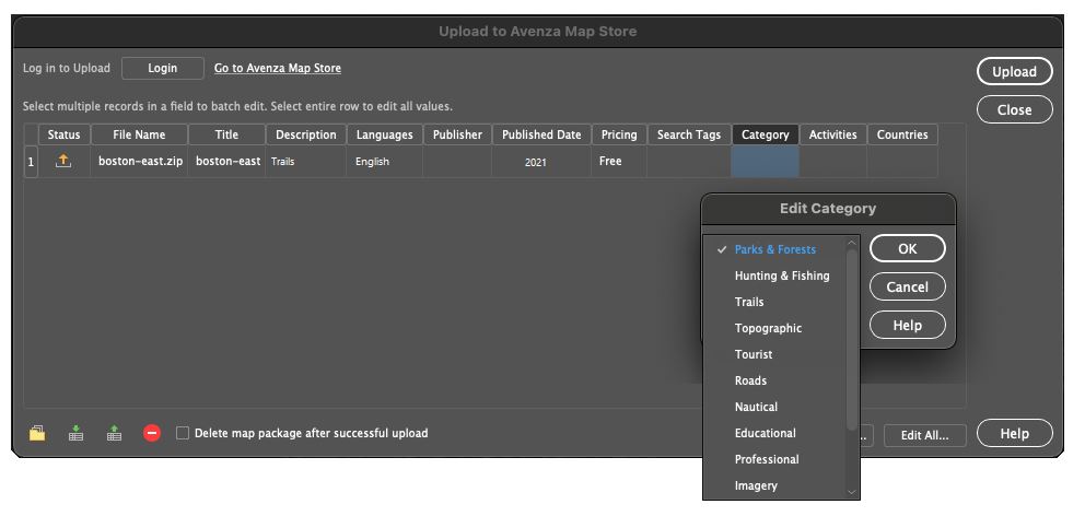
  • New Avenza Map Store categories: The new categories used for browsing maps on the Avenza Map Store have been added when using the  ‘Upload to Avenza Map Store” functionality.
  • Updated coordinate systems: Engine enhancements including an updated coordinate system library.

Geographic Imager 6.4 is immediately available and free of charge to all current Geographic Imager Maintenance Program members and starts at US$349 for non-maintenance upgrades. New fixed licenses start at US$749. Geographic Imager Basic Edition licenses start at US$99. Academic, floating, and volume license pricing is also available. For more information, visit www.avenza.com/geographic-imager.

More about Avenza Systems Inc.

Avenza Systems Inc. is an award-winning, privately held corporation that provides cartographers and GIS professionals with powerful software tools to make better maps. In addition to desktop mapping software, Avenza offers the mobile Avenza Maps app to sell, purchase, distribute, and use maps on iOS and Android devices. For more information, visit www.avenza.com.

For further information contact:  416-487-5116 – info@avenza.comwww.avenza.com

What’s new in Geographic Imager 6.4

What’s New in Geographic Imager 6.4

Avenza is pleased to announce the release of Geographic Imager® 6.4 for Adobe Photoshop®. This version is fully compatible with the latest version of Adobe Photoshop 2021. The release also introduces the ability to retain embedded georeferencing within saved Photoshop documents. We are also excited to provide scripting support for the export of point, text, and vector layers, updated map store upload options, new coordinate system support, and a host of bug fixes and engine enhancements.

Here is what you can expect with the latest Geographic Imager 6.4 release:

Georeferenced Photoshop Documents and Photoshop BIG files

We know that easily and efficiently importing and processing georeferenced imagery data directly within Adobe Photoshop make Geographic Imager the go-to platform for your imagery editing needs. With the release of Geographic Imager 6.4, working with georeferenced imagery is now simpler than ever. We have introduced the ability to retain embedded georeferencing information directly within a saved Photoshop Document (PSD). Geographic Imager will now store, and automatically read georeferencing specifications upon opening Photoshop documents. This reduces the need to retain an external reference file and means users will not have to specify this source reference information upon opening the file. Embedded georeferencing now works with all support images contained in Photoshop Documents, as well as very large georeferenced images contained in Photoshop BIG (PSB) files.

Upload Options: Avenza Map Store Categories

For users wishing to share or sell their maps on the Avenza Map Store, we have updated the “Upload to the Avenza Map Store” options to include the new Map Store categories. Map Store categories such as Parks & Forests, Trails, and Topographic are organized to enhance the search experience on the Map Store and ensure your high-quality map products reach the right users. When exporting from Geographic Imager to the Avenza Map Store, users will be provided an option to select one of 13 specific categories.

Scripting Support for Exporting Vector Layers

For handling repetitive imagery processing tasks, our users often employ the already powerful automation and scripting tools available in Adobe Photoshop. With Geographic Imager 6.4, we have introduced scripting capabilities for exporting vector layers. This means exporting vector points, lines, polygons, and text within Geographic Imager can now be recorded in the Adobe Photoshop Action panel. This new functionality allows users to script and automate export processes for their geospatial imagery.

Improved Coordinate System Library

For this release, we worked to improve the Geographic Imager engine that ensures our users can continue their work in a truly seamless, powerful, efficient, geospatial image-editing environment. This release includes performance enhancements, user interface improvements, and a host of bug fixes. Additionally, we have built on our existing coordinate system catalog with the addition of several new and updated projection and coordinate systems. These exciting additions include the Natural Earth and Natural Earth 2 Projections created by Tom Patterson. 

Get it today!

All active maintenance subscribers can upgrade to Geographic Imager 6.4 today for free. Users who don’t have active maintenance or are on a previous Geographic Imager version can still upgrade.