Whether you’re new to Avenza Maps®, an experienced user, or simply thinking about a purchase, Avenza Maps training is a worthwhile experience. Get hands-on training from Avenza product specialists at one of our training courses online virtually from anywhere.
Articles
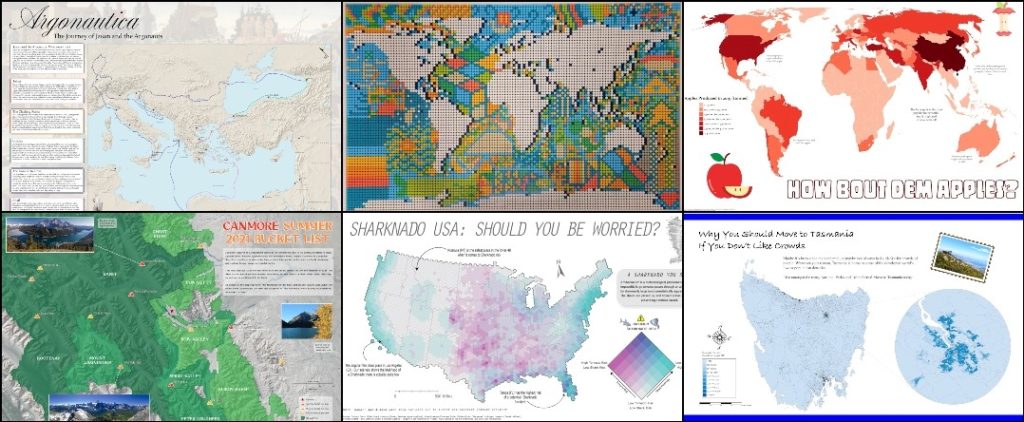
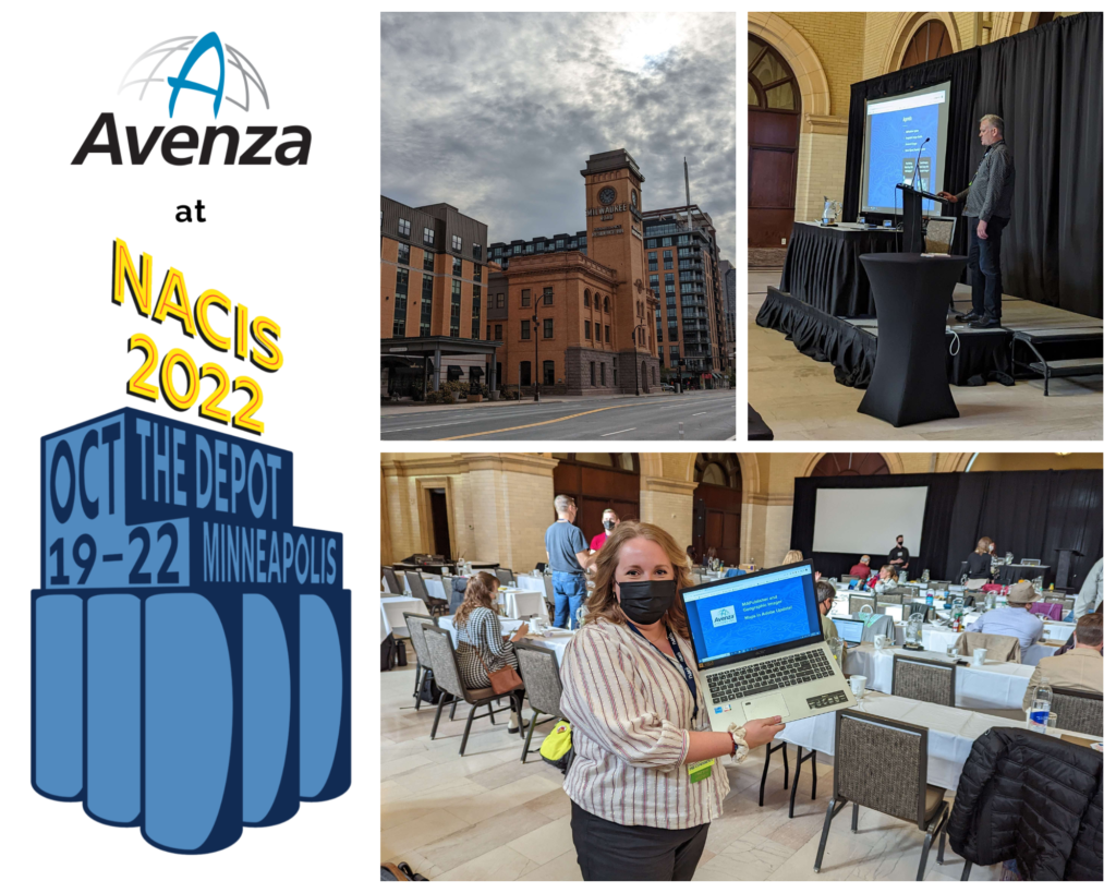
Whether you’re new to MAPublisher®, an experienced user, or simply thinking about a purchase, Avenza software training is a worthwhile experience. Get hands-on training from Avenza product specialists at one of our training courses around North America or virtually from anywhere. Whether you’re new to MAPublisher®, an experienced user, or simply thinking about a purchase, Avenza software training is a worthwhile experience. Get hands-on training from Avenza product specialists at one of our training courses around North America or virtually from anywhere. Whether you’re new to Geographic Imager, an experienced user, or simply thinking about a purchase, Avenza software training is a worthwhile experience. Get hands-on training from Avenza product specialists at one of our virtual training courses from anywhere. Whether you’re new to Avenza Maps®, an experienced user, or simply thinking about a purchase, Avenza Maps training is a worthwhile experience. Get hands-on training from Avenza product specialists at one of our training courses online virtually from anywhere. Whether you’re new to Avenza Maps®, an experienced user, or simply thinking about a purchase, Avenza Maps training is a worthwhile experience. Get hands-on training from Avenza product specialists at one of our training courses online virtually from anywhere. The Day 13 theme of the #30DayMapChallenge was more of a question: can you create a map in 5 minutes? Well, we were up for the challenge! Here at Avenza, we used this as an opportunity to teach our marketing team (with limited GIS experience) the basics of cartography. In the weeks leading up to this day, we taught them how to perform a few simple tasks in MAPublisher to create a basic map of South America. We broke down the process of making this map into five general steps for the purpose of simplicity. The first step was to import country area data using the Import button on the MAP Toolbar. After import, the Artboard tool was used to adjust map boundaries to the desired position. The MAP View Editor could also be used to fine-tune the movement of the data. The second step was to add a stylesheet to the countries using the MAP Themes button. From here a stylesheet was created by clicking the Add button and creating an area stylesheet. The stylesheet editor was then opened, and the style was assigned to the country layer. The Batch Generate Rules… button was very helpful in quickly creating categories for the data based on the desired attribute. For example, one map was created using the Population Density attribute. The categories were assigned a style based on a pre-selected colour ramp. Finally, a rule was created to create a grey style for the part of North America that attaches to South America. Using the hamburger menu button in the MAP Themes panel, step three included creating a legend for the map. Removing Rule 1 from the list and adding a title (if desired) were the only extra steps necessary here. In step four, the goal was to add a label for the country names. We used LabelPro for this to make it quick and simple. We enabled leader lines to ensure all countries were labeled even if the label was too large. Finally, we added a title and supplemental text and objects to the map. All of these elements were added to the document using native Adobe Illustrator tools. Our process of creating a map in 5 minutes was recorded and condensed into a 30-second video. See it, and the other resulting maps, below! A few weeks ago, between October 19th and 22nd, we had the pleasure of attending the 42nd North American Cartographic Information Society (NACIS) Annual Meeting in Minneapolis. NACIS provides a casual and friendly atmosphere for map-lovers from all over the world to come together and share their passion for cartography. Avenza usually conducts our presentation at NACIS as a part of Practical Cartography Day (PCD), using the opportunity to give a sneak peek at what’s to come in the upcoming year for our products, and demonstrate some of the cool functionalities of MAPublisher. During PCD we had the chance to share the latest and greatest tools in MAPublisher and Geographic Imager, and we also got to demo some of our favourite tools within MAPublisher. This year our presentation was headed by Nick Burchell, our Director of Quality Assurance here at Avenza, and Rebecca Bennett, our Publisher Success Coordinator. Nick highlighted the new and exciting features within our software this year, such as the new attribute viewer and erase tools in MAPublisher and georeferencing storage in PSD files in Geographic Imager. Rebecca closed out the presentation with a demonstration that focused on highlighting the usage of MAPublisher tools in creating a fantasy postal map of Toronto! Check out the presentation below: After returning from Minneapolis, we had the opportunity to get a comment from Rebecca about her first time at NACIS: “There were so many amazing and unique presentations this year, and it was really enjoyable and inspiring to be around so many talented cartographers and GIS professionals. Everyone has their own techniques and special flair with their maps and it was evident in their presentations, and also in the Map Gallery.” “Overall NACIS is a wonderful place to meet like minded people and share your love of maps!” Toronto, ON, November 1, 2022 – Avenza Systems Inc., producers of the Avenza Maps® app for mobile devices and geospatial extensions for Adobe Creative Cloud®, including Geographic Imager® for Adobe Photoshop®, is pleased to announce the release of MAPublisher® 11.1 for Adobe Illustrator®. This version offers full compatibility with Adobe Illustrator 2023 (Version 27.0) as well as with the brand new macOS Ventura (version 13) update. It also includes maintenance and bug fixes. MAPublisher cartography software seamlessly integrates more than seventy GIS mapping tools into Adobe Illustrator to help you create beautiful maps from geospatial data. Import industry-standard GIS data formats and make crisp, clean maps with all attributes and georeferencing intact using the Adobe Illustrator design environment. Users require a valid Adobe Creative Cloud subscription and a compatible operating system to utilize the improvements and enhancements offered in MAPublisher 11.1. For questions and information on how compatibility requirements may affect your organization, please contact our Support Centre. MAPublisher 11 is immediately available free of charge to all current MAPublisher users with active maintenance and as an upgrade for non-maintenance users starting at US$649. New licenses are available from US$1499. MAPublisher FME-Auto and MAPublisher LabelPro are also available as add-ons starting at US$499. Academic, floating, and volume licenses are also available. Prices include one year of full maintenance. Visit www.avenza.com/mapublisher for more details. More about Avenza Systems Inc. Avenza Systems Inc. is an award-winning, privately held corporation that provides cartographers and GIS professionals with powerful software tools to make better maps. Avenza also offers the mobile Avenza Maps app to sell, purchase, distribute, and use maps on iOS and Android devices. Tomorrow is November 1st, which means it’s time to start another year of the #30DayMapChallenge! The challenge is a Twitter-based daily map challenge which involves posting a map that suits the daily theme each day and tagging it with the hashtag #30DayMapChallenge. It was first started by Topi Tjukanov in 2019 and has been growing in popularity ever since. In 2021, the challenge ended up with over 9,000 submitted maps! The daily themes for the challenge are posted in early October each year, giving participants about a month to get a head start on planning some of their maps. Some examples of daily themes include maps that show colours, hexagons, fantasy, or islands. Some of the themes also function as a challenge, such as creating a “bad” map, the 5 minute map challenge, as well as a map that is created using new tools outside of your comfort zone. This year, we’ll be sharing some of our own maps created by Avenza employees, and highlighting some on-theme maps from the Avenza Map Store! We’re looking forward to seeing all of the interesting and innovative maps floating around the #30DayMapChallenge hashtag on Twitter. Remember, participants can post as many or as few maps as they wish. At the end of the day, it comes down to engaging in the ever growing community of cartography-lovers. We’ll see you on Twitter tomorrow for the Day 1 theme: points! Happy mapping! For more information about the #30DayMapChallenge – including the 2022 daily themes, visit the official website or check out the GitHub repository!
MAPublisher Virtual Training: September 23-25, 2025
MAPublisher Virtual Training: May 13-15, 2025
Geographic Imager Virtual Training: October 8, 2025
Avenza Maps Virtual Training: November 4-5, 2025
Avenza Maps Virtual Training: May 28-29, 2025
Can You Create a Map in 5 Minutes?
Simplified Steps for Creating a Map
Import Data
Stylize Data
Add a Legend
Add Labels
Add Finishing Touches
NACIS 2022 Recap
Avenza Releases MAPublisher 11.1 for Adobe Illustrator
For further information contact: +1 416-487-5116 – info@avenza.com – www.avenza.comJoin us for the #30DayMapChallenge!