We are excited to announce the release of MAPublisher 11.8 for Adobe Illustrator and Geographic Imager 7.1 for Adobe Photoshop, the latest updates to our geospatial extensions for Adobe Creative Cloud.
With these updates, we are announcing official compatibility with Adobe Creative Cloud 2026 and macOS Tahoe 26, as well as several other performance enhancements and bug fixes.
Here’s what you can expect with the latest MAPublisher 11.8 and Geographic Imager 7.1 releases:
Compatibility updates for Adobe Creative Cloud 2026
We are continuing to keep up with Adobe’s yearly updates, with Adobe Creative Cloud 2026 newly released in October. As such, MAPublisher 11.8 is compatible with Adobe Illustrator 2026 (version 30), and Geographic Imager 7.1 is compatible with Adobe Photoshop 2026 (version 27).
Compatibility updates for macOS Tahoe
We know our users have been waiting patiently since September for this one! Both MAPublisher 11.8 and Geographic Imager 7.1 are compatible with the recent upgrades seen in macOS Tahoe (version 26).
We hope that the aforementioned compatibility upgrades are helpful in keeping your mapping and geospatial imagery workflows running smoothly!
MAPublisher 11.8 and Geographic Imager 7.1 are available now!
If you want to learn more about the new MAPublisher 11.8 features or have any questions, please check out its documentation in our Support Centre.
If you want to learn more about the new Geographic Imager 7.1 features or have any questions, please check out its documentation in our Support Centre.
MAPublisher 11.8 and Geographic Imager 7.1 are immediately available today. They are free to all current MAPublisher or Geographic Imager users with active maintenance subscriptions and available as upgrades for non-maintenance users.
We hope that our products continue to deliver the tools you need to bridge the gap between geospatial precision and creative design!
Toronto, ON, November 5, 2025 – Avenza Systems Inc., producers of the Avenza Maps app for mobile devices and geospatial extensions for Adobe Creative Cloud, including MAPublisher for Adobe Illustrator, is excited to announce the release of Geographic Imager version 7.1 for Adobe Photoshop. This version introduces compatibility support for Adobe Photoshop 2026 and macOS Tahoe, as well as other performance enhancements and bug fixes.
Geographic Imager for Adobe Photoshop delivers an all-encompassing solution for importing, editing, and exporting geospatial images, such as aerial and satellite imagery. Work with digital elevation models, GeoTIFFs, and other popular GIS image formats using Adobe Photoshop features such as transparencies, filters, cropping, and image adjustments while maintaining georeferencing and support for hundreds of coordinate systems and projections.
New features for Geographic Imager 7.1 for Adobe Photoshop include:
Adobe Creative Cloud 2026 compatibility: Geographic Imager now supports Adobe Photoshop 2026 (version 27) on both Windows and Mac.
macOS Tahoe compatibility: Geographic Imager also officially supports the new macOS Tahoe (version 26) update.
Additional user interface and usability enhancements
To utilize the improvements and enhancements offered in Geographic Imager 7.1, users require a valid Adobe Creative Cloud subscription and a compatible operating system. For questions and information on how compatibility requirements may affect your organization, please contact our Support Centre.
Geographic Imager 7.1 is available immediately and free of charge to all current Geographic Imager Maintenance Program members and starts at US$599 for non-maintenance upgrades. New fixed licenses start at US$899. Geographic Imager Basic Edition licenses start at US$135. Academic, floating, and volume license pricing is also available. Visit www.avenza.com/geographic-imager for more information.
More about Avenza Systems Inc.
Avenza Systems Inc. is an award-winning, privately held corporation that provides cartographers and GIS professionals with powerful software tools to create more accurate and effective maps. Avenza also offers the mobile Avenza Maps app to sell, purchase, distribute, and use maps on iOS and Android devices. For further information, contact: +1 (416) 487-5116 – info@avenza.com – www.avenza.com
Toronto, ON, November 4, 2025 – Avenza Systems Inc., producer of the Avenza Maps app for mobile devices and geospatial extensions for Adobe Creative Cloud, including Geographic Imager for Adobe Photoshop, is excited to announce the release of MAPublisher version 11.8 for Adobe Illustrator. This version introduces compatibility support for Adobe Illustrator 2026 and macOS Tahoe, as well as other performance enhancements and bug fixes.
MAPublisher cartography software seamlessly integrates more than seventy GIS mapping tools into Adobe Illustrator to help users create beautiful maps from geospatial data. Import industry-standard GIS data formats and make crisp, clean maps with all attributes and georeferencing intact using the Adobe Illustrator design environment.
New features of MAPublisher 11.8 for Adobe Illustrator include:
Adobe Creative Cloud 2026 compatibility: MAPublisher now supports Adobe Illustrator 2026 (version 30) on both Mac and Windows
macOS Tahoe compatibility: MAPublisher also officially supports the new macOS Tahoe (version 26) update
Additional performance enhancements and bug fixes
To utilize the improvements and enhancements offered in MAPublisher 11.8, users require a valid Adobe Creative Cloud subscription and a compatible operating system. For questions and information on how compatibility requirements may affect your organization, please contact our Support Centre.
MAPublisher 11.8 is immediately available free of charge to all current MAPublisher users with active maintenance and as an upgrade for non-maintenance users starting at US$999. New licenses are available from US$1,749. MAPublisher FME Auto and MAPublisher LabelPro are also available as add-ons starting at US$599. Academic, floating, and volume licenses are also available. Prices include one year of full maintenance. Visit www.avenza.com/mapublisher for more details.
More about Avenza Systems Inc.
Avenza Systems Inc. is an award-winning, privately held corporation that provides cartographers and GIS professionals with powerful software tools to make better maps. Avenza also offers the mobile Avenza Maps app to sell, purchase, distribute, and use maps on iOS and Android devices. For further information contact: +1 (416) 487-5116 – info@avenza.com – www.avenza.com
Toronto, ON, September 5, 2025 – Avenza Systems Inc., producers of the Avenza Maps app for mobile devices and geospatial extensions for Adobe Creative Cloud, including MAPublisher for Adobe Illustrator, is pleased to announce the release of Geographic Imager version 7.0 for Adobe Photoshop. This version introduces several updates to the Terrain Shader tool as well as other performance enhancements and bug fixes.
Geographic Imager for Adobe Photoshop delivers an all-encompassing solution for importing, editing, and exporting geospatial images, such as aerial and satellite imagery. Work with digital elevation models, GeoTIFFs, and other popular GIS image formats using Adobe Photoshop features such as transparencies, filters, cropping, and image adjustments while maintaining georeferencing and support for hundreds of coordinate systems and projections.
New features for Geographic Imager 7.0 for Adobe Photoshop include:
Texture shading option in Terrain Shader: Texture shading utilizes an algorithm developed by Leland Brown to generate a texture shade, which offers a more natural representation of terrain when combined with a standard shaded relief.
Eleven new colour maps in Terrain Shader: Geographic Imager 7.0 introduces a complete overhaul of the default colour maps available in Terrain Shader, featuring eleven newly updated colour maps with practical gradients ranging from natural to scientific.
Terrain Shader relief preview toggle: It is now possible to toggle the relief preview on/off when using the Terrain Shader, which is especially ideal when working with large DEMs.
Additional user interface and usability enhancements
To utilize the improvements and enhancements offered in Geographic Imager 7.0, users require a valid Adobe Creative Cloud subscription and a compatible operating system. For questions and information on how compatibility requirements may affect your organization, please contact our Support Centre.
Geographic Imager 7.0 is available immediately and free of charge to all current Geographic Imager Maintenance Program members and starts at US$599 for non-maintenance upgrades. New fixed licenses start at US$899. Geographic Imager Basic Edition licenses start at US$135. Academic, floating, and volume license pricing is also available. Visit www.avenza.com/geographic-imager for more information.
More about Avenza Systems Inc.
Avenza Systems Inc. is an award-winning, privately held corporation that provides cartographers and GIS professionals with powerful software tools to create more accurate and effective maps. Avenza also offers the mobile Avenza Maps app to sell, purchase, distribute, and use maps on iOS and Android devices. For further information, contact: +1 (416) 487-5116 – info@avenza.com – www.avenza.com
We are excited to announce the release of Geographic Imager version 7.0, the latest version of our Geographic Imager extension for Adobe Photoshop.
With Geographic Imager 7.0, we are introducing several updates to the Terrain Shader tool, including a new relief option called texture shading, 11 new colour maps, and a toggle button for the relief preview, as well as other performance enhancements and bug fixes.
Here’s what you can expect with the latest Geographic Imager 7.0 release:
Terrain Shader improvements
Texture Shading
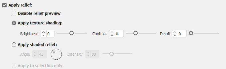
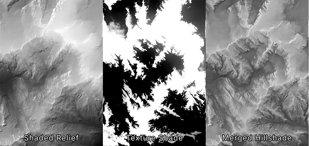
With this Geographic Imager release comes many improvements to the Terrain Shader, starting with a new relief option called texture shading. This option utilizes an algorithm developed by Leland Brown to generate a texture shade, which offers a more natural representation of terrain than a standard shaded relief with a single light source. While a texture shade is more successful at depicting the subtle differences in terrain, it is not the type of terrain we are used to seeing on maps—especially when there is a high contrast between the dark valleys and light ridges of a particular DEM. This can be mitigated by merging a texture shade with a shaded relief to achieve a hillshade that combines the best of both worlds!
Using the Terrain Shader with “Apply relief” enabled, you can now choose to apply texture shading or shaded relief to your DEM. The texture shading option allows you to control the brightness, contrast, and detail of your texture shade to ensure that you can finetune the visualization of your map’s hillshade. After outputting your texture shade, you can merge this image with your shaded relief image in Photoshop to create the ideal custom hillshade for your map.
New colour maps
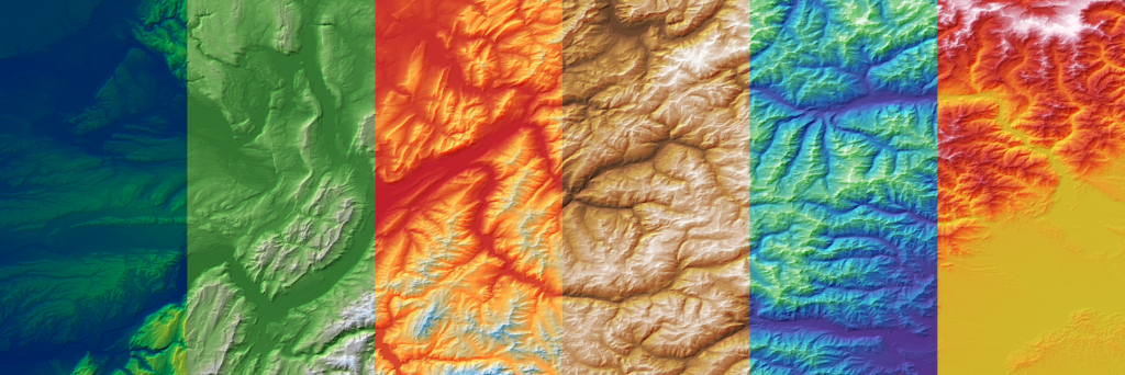
Geographic Imager 7.0 introduces a complete overhaul of the default colour maps available in Terrain Shader, with eleven brand new colour maps to choose from! The new gradients feature more practical colourization and were designed with usability in mind. Whether you are looking for a more natural-looking colour map or something a little more artificial or scientific, these new defaults have you covered. As always, the default colour maps are 100% editable to ensure you can create something that suits your map’s aesthetic!
Disable relief preview toggle
Terrain Shader also now features a “Disable relief preview” checkbox, which allows you to toggle the relief preview on and off as needed. This is a small but useful tool when working with large DEMs, which can slow down the software when generating previews for reliefs. This button is located under the “Apply relief” checkbox.
Geographic Imager 7.0 is Available Now!
If you want to learn more about the new Geographic Imager 7.0 features or have any questions, please check out our Support Centre.
Geographic Imager 7.0 is available immediately, free of charge, to all current Geographic Imager users with active maintenance subscriptions and as an upgrade for non-maintenance users.
Toronto, ON, May 27, 2025 – Avenza Systems Inc., producer of the Avenza Maps app for mobile devices and geospatial extensions for Adobe Creative Cloud, including Geographic Imager for Adobe Photoshop, is pleased to announce the release of MAPublisher version 11.7 for Adobe Illustrator. This version introduces support for database formats to the Manage Data Links tool, compatibility with FME Form 2025, as well as other performance enhancements and bug fixes.
MAPublisher cartography software seamlessly integrates more than seventy GIS mapping tools into Adobe Illustrator to help users create beautiful maps from geospatial data. Import industry-standard GIS data formats and make crisp, clean maps with all attributes and georeferencing intact using the Adobe Illustrator design environment.
New features of MAPublisher 11.7 for Adobe Illustrator include:
Manage Data Links with database connections: The Manage Data Links tool now supports connections with PostGIS databases and Esri Geodatabases, including some user interface upgrades.
FME Form 2025 compatibility: MAPublisher now supports the recent FME 2025.0 update when using the FME Auto add-on.
Additional performance enhancements and bug fixes
To utilize the improvements and enhancements offered in MAPublisher 11.7, users require a valid Adobe Creative Cloud subscription and a compatible operating system. For questions and information on how compatibility requirements may affect your organization, please contact our Support Centre.
MAPublisher 11.7 is immediately available free of charge to all current MAPublisher users with active maintenance and as an upgrade for non-maintenance users starting at US$999. New licenses are available from US$1,749. MAPublisher FME Auto and MAPublisher LabelPro are also available as add-ons starting at US$599. Academic, floating, and volume licenses are also available. Prices include one year of full maintenance. Visit www.avenza.com/mapublisher for more details.
More about Avenza Systems Inc.
Avenza Systems Inc. is an award-winning, privately held corporation that provides cartographers and GIS professionals with powerful software tools to make better maps. Avenza also offers the mobile Avenza Maps app to sell, purchase, distribute, and use maps on iOS and Android devices. For further information contact: 416-487-5116 – info@avenza.com – www.avenza.com
We are thrilled to announce the release of MAPublisher version 11.7, the latest update to our MAPublisher extension for Adobe Illustrator.
MAPublisher 11.7 introduces support for database connections in the Manage Data Links tool, compatibility with FME Form 2025, as well as other performance enhancements and bug fixes.
Here’s what you can expect with the latest MAPublisher 11.7 release:
Manage Data Links with database connections
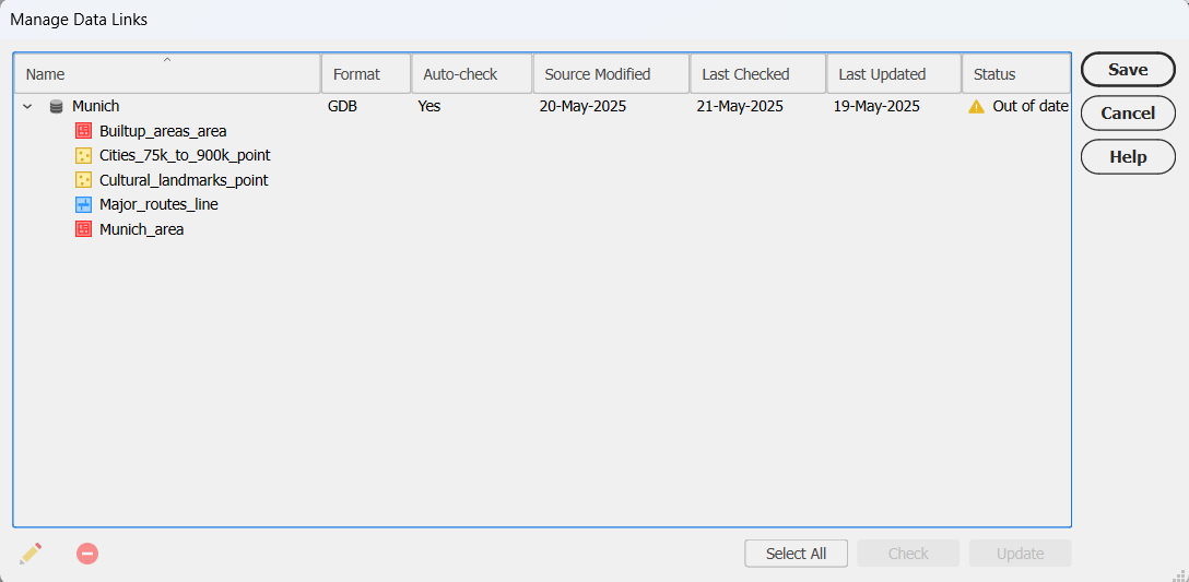
Are you tired of re-importing your databases every time you make changes to them? Well we have great news for you! We are excited to report that with MAPublisher 11.7, the Manage Data Links tool now supports connections with database formats such as PostGIS databases and Esri Geodatabases!
Visual cues for out-of-date datasets
Linked databases can now be managed and updated using the Manage Data Links dialog box, which can be accessed from the MAP Views panel. Database formats such as MDB or GDB will display a yellow warning icon in the status column to notify you that the source database is out of date. Simply click the Update button in the bottom right corner of the dialog box to sync your data changes!
Linking your databases to MAPublisher is also a great way to quickly sync and update the data on your maps without having to re-style the data. MAP Themes are automatically applied to new data added to a previously styled MAP Layer.
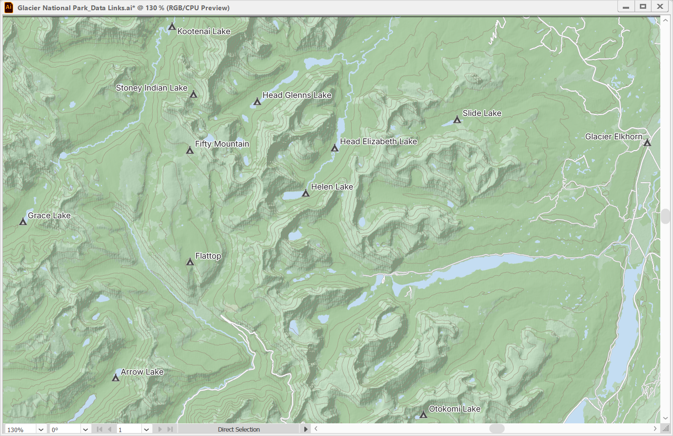
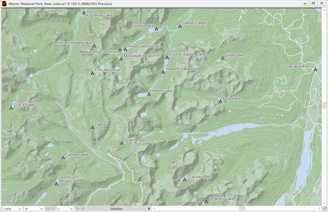
In the example below, a map showing campsites within Glacier National Park has campsite point data and contour line data stored in a PostGIS database.
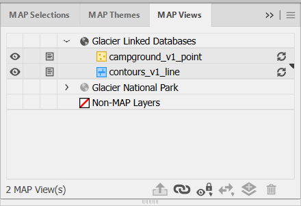
Opening the Manage Data Links window is not the only way to update your linked databases. The MAP Views panel also features visual cues that warn users whether their datasets connected from linked databases are out of date or available to be updated. These will appear as yellow symbols for file-based databases such as GDB and MDB.
Unlike file-based databases, which store data as files with detectable modification timestamps, PostGIS databases are server-based and do not provide a reliable way to track changes. As a result, MAPublisher cannot automatically detect updates in PostGIS datasets. Instead, PostGIS datasets will display a grey update icon next to them, allowing you to pull possible updates at any time.
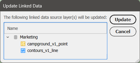
Clicking this icon will open a prompt where you can confirm which MAP Layers you would like to be updated.
After updating, you can see that new campsites and more detailed contour lines have been added to the map and styled accordingly. With a quick run of the LabelPro tool, the labels for the new campsites have been added and the map is fully updated in just a few minutes!
User interface improvements for databases
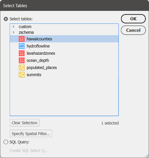
The Import dialog box for database formats now features a few upgrades to the user interface to make the import process clearer. The Select Tables window now has the option to select all or clear your selections at the bottom, and also shows the number of currently selected tables.
To learn more about the Manage Data Links tool, check out its support article.
Compatibility with FME Form 2025
MAPublisher FME Auto is a Windows-only powerful add-on that connects the GIS data processing environment of FME Form to the cartographic design and publishing environment of MAPublisher and Adobe Illustrator. MAPublisher 11.7 is the first version of MAPublisher to provide support for the recent FME Form 2025.0 update.
MAPublisher 11.7 is available now!
If you want to learn more about the new MAPublisher 11.7 features or have any questions, please check out our Support Centre. MAPublisher 11.7 is immediately available today. It is free to all current MAPublisher users with active maintenance subscriptions and available as an upgrade for non-maintenance users.
We are thrilled to offer a deeper dive into another helpful enhancement new to MAPublisher 11.6: Point Scaling, now a calculation option available in the Add Calculated Data tool.
Scaling points is a simple and easy-to-understand method to visually represent the differences in magnitude within a point dataset directly on your maps. Whether you’re mapping city population sizes, earthquake magnitudes, or any other quantitative data, point scaling makes it easy to convey differences in quantity at a glance directly through your map symbols.
In our most recent video, we take you through a basic workflow for setting up a Point Scaling calculation using the Add Calculated Data tool and then scaling your points based on the output of the calculation. Using a map of the Netherlands, the example in the video shows you how to scale city points based on population values.
The video contains an overview of how to set up a Point Scaling calculation, including the four scaling methods available in the tool—Area, Exponential, Flannery, and Radius—as well as selecting the proper Source variable, Target attribute field, and value range.
Once the Point Scaling calculation is run, the video also shows you how to use the newly created attribute with the Scale & Rotate by Attribute tool to resize your points. An even quicker option for scaling your points is to select the Automatically Apply Point Scaling to Layer checkbox before running the calculation!
The Point Scaling feature is ideal for users who want to make their maps more infortmative without manual resizing, complicated workflows, or cluttered supplemental text. With just a few clicks, you can transform your data into an intuitive visual representation!
Ready to try it out? Watch the full demonstration below to see how Point Scaling works in action, and how you can enhance your own maps with smarter symbol sizing in MAPublisher 11.6.
For more information on Point Scaling calculations and the four scaling methods, check out our Support Page for the Add Calculated Data tool.
We’ve recently added a deliciously useful feature to MAPublisher: waffle charts!
Waffle charts are grid-based visualizations where each cell represents a fixed quantity of data. They offer a clear, easy-to-read alternative to traditional pie charts, especially when comparing multiple categories or displaying categories with small percentages. Whether you’re working with population figures, economic data, or any other dataset, waffle charts can help your map users quickly compare proportions or observe patterns.
In our newest video, we walk you through the process of creating waffle charts in MAPublisher 11.6, starting in the MAP Themes panel. Our demonstration compares exports between Canada and the United States across nine different categories, from oil and minerals to food and transportation products.
The video contains a brief overview for creating a waffle chart, using the Edit Chart Theme window to specify your settings (including some new options specific to waffle charts), and how to set up a legend to assist users in interpreting your charts.
With editable styling options that allow full customization of the appearance of your waffle charts, this new chart type is a fantastic way to enhance the visual storytelling power of your maps. Waffle charts can even be styled using native Illustrator graphic styles or custom swatches you’ve created yourself!
Ready to get started? Watch the full demonstration below to find out just how easy it is to bring your data to life in a new way with waffle charts in MAPublisher 11.6.
For more information on waffle charts, check out our Support Page for Chart Themes.
Toronto, ON, March 25, 2025 – Avenza Systems Inc., producer of the Avenza Maps app for mobile devices and geospatial extensions for Adobe Creative Cloud, including Geographic Imager for Adobe Photoshop, is pleased to announce the release of MAPublisher version 11.6 for Adobe Illustrator. This version introduces waffle charts to the MAP Themes chart types, adds a Point Scaling option to the Add Calculated Data tool, and offers other performance enhancements and bug fixes.
MAPublisher cartography software seamlessly integrates more than seventy GIS mapping tools into Adobe Illustrator to help users create beautiful maps from geospatial data. Import industry-standard GIS data formats and make crisp, clean maps with all attributes and georeferencing intact using the Adobe Illustrator design environment.
New features of MAPublisher 11.6 for Adobe Illustrator include:
Introduction of waffle charts to MAP Themes chart types: Waffle charts can now be created in MAPublisher by opening the MAP Themes panel, creating a Chart Theme, and selecting “Waffle chart” from the Type drop-down menu.
Addition of a Point Scaling option to the Add Calculated Data tool: The Add Calculated Data tool now features a Calculation type of “Point Scaling,” which creates an attribute for point scaling values derived from an existing attribute in a dataset.
Additional performance enhancements and bug fixes
To utilize the improvements and enhancements offered in MAPublisher 11.6, users require a valid Adobe Creative Cloud subscription and a compatible operating system. For questions and information on how compatibility requirements may affect your organization, please contact our Support Centre.
MAPublisher 11.6 is immediately available free of charge to all current MAPublisher users with active maintenance and as an upgrade for non-maintenance users starting at US$999. New licenses are available from US$1,749. MAPublisher FME Auto and MAPublisher LabelPro are also available as add-ons starting at US$599. Academic, floating, and volume licenses are also available. Prices include one year of full maintenance. Visit www.avenza.com/mapublisher for more details.
More about Avenza Systems Inc.
Avenza Systems Inc. is an award-winning, privately held corporation that provides cartographers and GIS professionals with powerful software tools to make better maps. Avenza also offers the mobile Avenza Maps app to sell, purchase, distribute, and use maps on iOS and Android devices. For further information contact: 416-487-5116 – info@avenza.com – www.avenza.com