Toronto, ON, May 27, 2025 – Avenza Systems Inc., producer of the Avenza Maps app for mobile devices and geospatial extensions for Adobe Creative Cloud, including Geographic Imager for Adobe Photoshop, is pleased to announce the release of MAPublisher version 11.7 for Adobe Illustrator. This version introduces support for database formats to the Manage Data Links tool, compatibility with FME Form 2025, as well as other performance enhancements and bug fixes.
MAPublisher cartography software seamlessly integrates more than seventy GIS mapping tools into Adobe Illustrator to help users create beautiful maps from geospatial data. Import industry-standard GIS data formats and make crisp, clean maps with all attributes and georeferencing intact using the Adobe Illustrator design environment.
New features of MAPublisher 11.7 for Adobe Illustrator include:
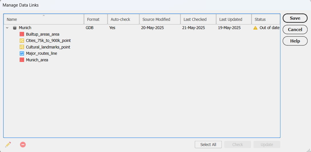
Manage Data Links with database connections: The Manage Data Links tool now supports connections with PostGIS databases and Esri Geodatabases, including some user interface upgrades.
FME Form 2025 compatibility: MAPublisher now supports the recent FME 2025.0 update when using the FME Auto add-on.
Additional performance enhancements and bug fixes
To utilize the improvements and enhancements offered in MAPublisher 11.7, users require a valid Adobe Creative Cloud subscription and a compatible operating system. For questions and information on how compatibility requirements may affect your organization, please contact our Support Centre.
MAPublisher 11.7 is immediately available free of charge to all current MAPublisher users with active maintenance and as an upgrade for non-maintenance users starting at US$999. New licenses are available from US$1,749. MAPublisher FME Auto and MAPublisher LabelPro are also available as add-ons starting at US$599. Academic, floating, and volume licenses are also available. Prices include one year of full maintenance. Visit www.avenza.com/mapublisher for more details.
More about Avenza Systems Inc.
Avenza Systems Inc. is an award-winning, privately held corporation that provides cartographers and GIS professionals with powerful software tools to make better maps. Avenza also offers the mobile Avenza Maps app to sell, purchase, distribute, and use maps on iOS and Android devices. For further information contact: 416-487-5116 – info@avenza.com – www.avenza.com
We are thrilled to announce the release of MAPublisher version 11.7, the latest update to our MAPublisher extension for Adobe Illustrator.
MAPublisher 11.7 introduces support for database connections in the Manage Data Links tool, compatibility with FME Form 2025, as well as other performance enhancements and bug fixes.
Here’s what you can expect with the latest MAPublisher 11.7 release:
Manage Data Links with database connections
Are you tired of re-importing your databases every time you make changes to them? Well we have great news for you! We are excited to report that with MAPublisher 11.7, the Manage Data Links tool now supports connections with database formats such as PostGIS databases and Esri Geodatabases!
Visual cues for out-of-date datasets
Linked databases can now be managed and updated using the Manage Data Links dialog box, which can be accessed from the MAP Views panel. Database formats such as MDB or GDB will display a yellow warning icon in the status column to notify you that the source database is out of date. Simply click the Update button in the bottom right corner of the dialog box to sync your data changes!
Linking your databases to MAPublisher is also a great way to quickly sync and update the data on your maps without having to re-style the data. MAP Themes are automatically applied to new data added to a previously styled MAP Layer.
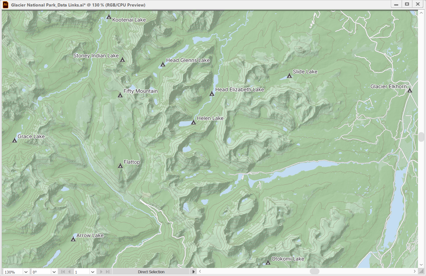
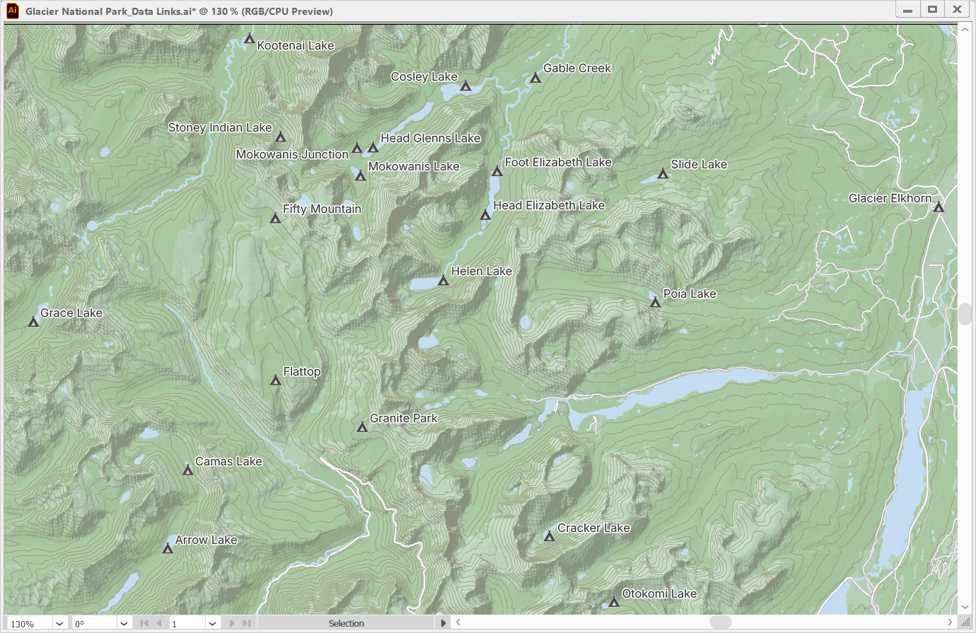
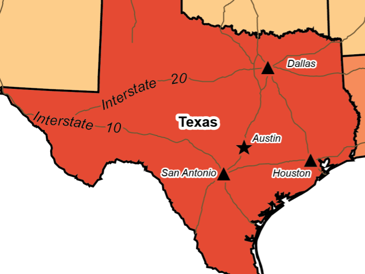
In the example below, a map showing campsites within Glacier National Park has campsite point data and contour line data stored in a PostGIS database.
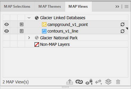
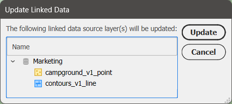
Opening the Manage Data Links window is not the only way to update your linked databases. The MAP Views panel also features visual cues that warn users whether their datasets connected from linked databases are out of date or available to be updated. These will appear as yellow symbols for file-based databases such as GDB and MDB.
Unlike file-based databases, which store data as files with detectable modification timestamps, PostGIS databases are server-based and do not provide a reliable way to track changes. As a result, MAPublisher cannot automatically detect updates in PostGIS datasets. Instead, PostGIS datasets will display a grey update icon next to them, allowing you to pull possible updates at any time.
Clicking this icon will open a prompt where you can confirm which MAP Layers you would like to be updated.
After updating, you can see that new campsites and more detailed contour lines have been added to the map and styled accordingly. With a quick run of the LabelPro tool, the labels for the new campsites have been added and the map is fully updated in just a few minutes!
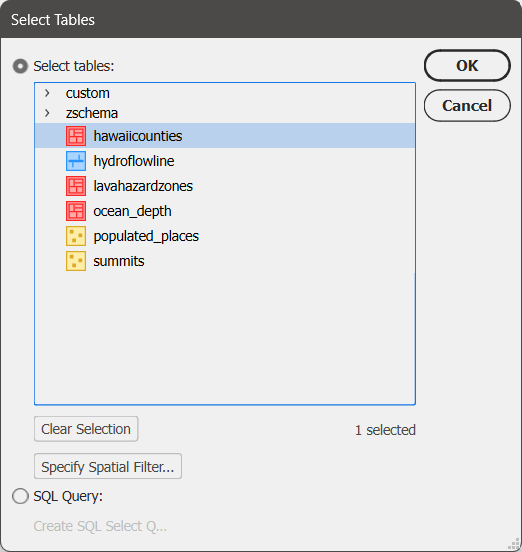
User interface improvements for databases
The Import dialog box for database formats now features a few upgrades to the user interface to make the import process clearer. The Select Tables window now has the option to select all or clear your selections at the bottom, and also shows the number of currently selected tables.
To learn more about the Manage Data Links tool, check out its support article.
Compatibility with FME Form 2025
MAPublisher FME Auto is a Windows-only powerful add-on that connects the GIS data processing environment of FME Form to the cartographic design and publishing environment of MAPublisher and Adobe Illustrator. MAPublisher 11.7 is the first version of MAPublisher to provide support for the recent FME Form 2025.0 update.
MAPublisher 11.7 is available now!
If you want to learn more about the new MAPublisher 11.7 features or have any questions, please check out our Support Centre. MAPublisher 11.7 is immediately available today. It is free to all current MAPublisher users with active maintenance subscriptions and available as an upgrade for non-maintenance users.
Toronto, ON, March 25, 2025 – Avenza Systems Inc., producer of the Avenza Maps app for mobile devices and geospatial extensions for Adobe Creative Cloud, including Geographic Imager for Adobe Photoshop, is pleased to announce the release of MAPublisher version 11.6 for Adobe Illustrator. This version introduces waffle charts to the MAP Themes chart types, adds a Point Scaling option to the Add Calculated Data tool, and offers other performance enhancements and bug fixes.
MAPublisher cartography software seamlessly integrates more than seventy GIS mapping tools into Adobe Illustrator to help users create beautiful maps from geospatial data. Import industry-standard GIS data formats and make crisp, clean maps with all attributes and georeferencing intact using the Adobe Illustrator design environment.
New features of MAPublisher 11.6 for Adobe Illustrator include:
Introduction of waffle charts to MAP Themes chart types: Waffle charts can now be created in MAPublisher by opening the MAP Themes panel, creating a Chart Theme, and selecting “Waffle chart” from the Type drop-down menu.
Addition of a Point Scaling option to the Add Calculated Data tool: The Add Calculated Data tool now features a Calculation type of “Point Scaling,” which creates an attribute for point scaling values derived from an existing attribute in a dataset.
Additional performance enhancements and bug fixes
To utilize the improvements and enhancements offered in MAPublisher 11.6, users require a valid Adobe Creative Cloud subscription and a compatible operating system. For questions and information on how compatibility requirements may affect your organization, please contact our Support Centre.
MAPublisher 11.6 is immediately available free of charge to all current MAPublisher users with active maintenance and as an upgrade for non-maintenance users starting at US$999. New licenses are available from US$1,749. MAPublisher FME Auto and MAPublisher LabelPro are also available as add-ons starting at US$599. Academic, floating, and volume licenses are also available. Prices include one year of full maintenance. Visit www.avenza.com/mapublisher for more details.
More about Avenza Systems Inc.
Avenza Systems Inc. is an award-winning, privately held corporation that provides cartographers and GIS professionals with powerful software tools to make better maps. Avenza also offers the mobile Avenza Maps app to sell, purchase, distribute, and use maps on iOS and Android devices. For further information contact: 416-487-5116 – info@avenza.com – www.avenza.com
We are excited to announce the release of MAPublisher version 11.6, the latest update to our MAPublisher extension for Adobe Illustrator.
MAPublisher 11.6 introduces waffle charts to the MAP Themes chart types, a Point Scaling option to the Add Calculated Data tool, and other performance enhancements and bug fixes.
Here’s what you can expect with the latest MAPublisher 11.6 release:
Waffle chart option added to MAP Themes
The MAP Themes panel welcomes a brand new chart type to MAPublisher 11.6: waffle charts! A waffle chart is a grid composed of equally sized cells, each coloured to depict different categories or segments. It is useful for comparing categories and displaying proportions. Waffle charts are typically used as an alternative to pie charts, making it easier to compare areas, visualize categories with small percentages, and generally make charts more readable.
To create waffle charts in MAPublisher 11.6, open the MAP Themes panel and create a Chart Theme as you usually would. When you open the Edit Chart Theme window, you will notice the brand new “Waffle chart” option in the Type drop-down menu.
As seen in the above image, configuring a waffle chart is very similar to configuring the other chart types with the usual option tabs such as Source Data, Chart Options, General Options, and Title available for customization. The Chart Options tab features a few new options specific to creating waffle charts, including a Calculate Default Scale button to help select a suitable value for the data represented in each cell.
To learn more about creating waffle charts in MAPublisher, check out the support page for Chart Themes.
Add Calculated Data now features a point scaling option
The Add Calculated Data tool—found in the Data Creation section of the MAP Toolbar—gains a new calculation option in MAPublisher 11.6. When the selected Layer is a point layer, the brand new “Point Scaling” option will become available in the Calculation drop-down menu.
The Point Scaling option adds a field to your attributes containing a calculation for point scaling sourced from an existing numeric attribute. The “Automatically Apply Point Scaling to Layer” checkbox allows you to immediately resize your points according to the selected scaling settings upon clicking “OK” to close the window instead of creating a new attribute. There are four Scale Methods to choose from, each calculating the scale slightly differently depending on which factors are important to you. For example, selecting the Flannery method applies a correction factor to account for natural human bias that causes us to underestimate the size of larger symbols. In contrast, choosing the Exponential method increases the size of symbols exponentially relative to their data values to emphasize differences, especially among larger values.
MAPublisher 11.6 is available now!
If you want to learn more about the new MAPublisher 11.6 features or have any questions, please check out our Support Centre. MAPublisher 11.6 is immediately available today. It is free to all current MAPublisher users with active maintenance subscriptions and available as an upgrade for non-maintenance users.
Toronto, ON, December 17, 2024 – Avenza Systems Inc., producers of the Avenza Maps® app for mobile devices and geospatial extensions for Adobe Creative Cloud®, including MAPublisher® for Adobe Illustrator®, is pleased to announce the release of Geographic Imager® version 6.9 for Adobe Photoshop®. This version introduces official compatibility with Adobe Photoshop 2025 and macOS Sequoia, WMS 1.3.0 import capabilities, support for NITF metadata, and also includes user interface and usability enhancements.
Geographic Imager for Adobe Photoshop delivers an all-encompassing solution for importing, editing, and exporting geospatial images, such as aerial and satellite imagery. Work with digital elevation models, GeoTIFFs, and other popular GIS image formats using Adobe Photoshop features such as transparencies, filters, cropping, and image adjustments while maintaining georeferencing and support for hundreds of coordinate systems and projections.
New features for Geographic Imager v6.9 for Adobe Photoshop include:
Adobe Creative Cloud 2025 compatibility: Geographic Imager now supports Adobe Photoshop 2025 (version 26.0) on both Windows and Mac.
macOS Sequoia compatibility: Geographic Imager also officially supports the new macOS Sequoia (version 15) update.
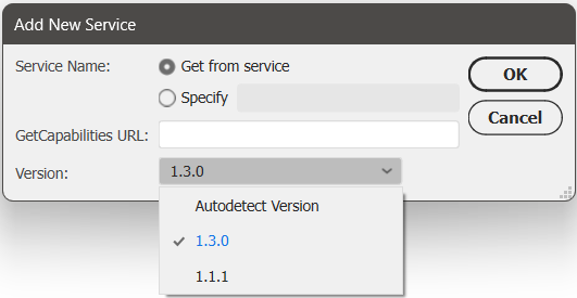
WMS 1.3.0 import capabilities: Geographic Imager now supports the import of data from Web Map Service (WMS) version 1.3.0, with an option to autodetect the WMS version also added.
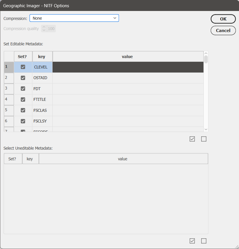
Support for NITF metadata: NITF metadata will now be maintained when NITF files are imported into Geographic Imager. Users can also specify image compression, edit certain metadata fields, and choose which metadata fields to include when exporting to NITF file format.
Additional user interface and usability enhancements
To utilize the improvements and enhancements offered in Geographic Imager v6.9, users require a valid Adobe Creative Cloud subscription and a compatible operating system. For questions and information on how compatibility requirements may affect your organization, please contact our Support Centre.
Geographic Imager v6.9 is available immediately and free of charge to all current Geographic Imager Maintenance Program members and starts at US$399 for non-maintenance upgrades. New fixed licenses start at US$859. Geographic Imager Basic Edition licenses start at US$129. Academic, floating, and volume license pricing is also available. Visit www.avenza.com/geographic-imager for more information.
More about Avenza Systems Inc.
Avenza Systems Inc. is an award-winning, privately held corporation that provides cartographers and GIS professionals with powerful software tools to make better maps. Avenza also offers the mobile Avenza Maps app to sell, purchase, distribute, and use maps on iOS and Android devices. For further information contact: +1 416-487-5116 – info@avenza.com – www.avenza.com
We are excited to announce the release of Geographic Imager version 6.9, the latest version of our Geographic Imager® extension for Adobe Photoshop®.
With Geographic Imager v6.9, we are announcing official compatibility with Adobe Photoshop 2025 and macOS Sequoia, WMS 1.3.0 import capabilities, support for NITF metadata, and other user interface and usability enhancements.
Here’s what you can expect with the latest Geographic Imager v6.9 release:
Compatibility upgrades
Following our extensive MAPublisher compatibility upgrades earlier this fall, we are happy to share that Geographic Imager 6.9 is fully compatible with Adobe Photoshop 2025 (version 26), which was released this October. Geographic Imager 6.9 also supports the recently released macOS Sequoia (version 15).
Import data from WMS 1.3.0
We have had many users request the ability to import data from Web Map Service (WMS) version 1.3.0, and we are happy to announce that this is now possible with Geographic Imager 6.9! This can be done by opening the Advanced Import window and following the usual steps to add a web map service. Select 1.3.0 from the new Version drop-down menu, or select the “Autodetect Version” option in this menu, which can detect the WMS version used by the URL provided.
Support for NITF metadata
NITF metadata will now be maintained when you import NITF files into Geographic Imager. When you go to quick save a document to NITF file format, you will now be met with an “NITF Options” dialog box. Here you can specify image compression, edit certain metadata fields, and choose which metadata fields to include in your saved NITF file.
Geographic Imager 6.9 is Available Now!
If you would like to learn more about the new Geographic Imager 6.9 features or have any questions, please check out our Support Centre.
Geographic Imager v6.9 is available immediately, free of charge to all current Geographic Imager users with active maintenance subscriptions and as an upgrade for non-maintenance users.
Toronto, ON, November 5, 2024 – Avenza Systems Inc., producer of the Avenza Maps® app for mobile devices and geospatial extensions for Adobe Creative Cloud®, including Geographic Imager® for Adobe Photoshop®, is pleased to announce the release of MAPublisher® version 11.5 for Adobe Illustrator®. This version introduces several compatibility updates, importing Vector Basemaps from custom tile sources, the ability to use the Join Table feature with existing MAP Layers, a new Split Line path utility, and several performance enhancements and bug fixes.
MAPublisher cartography software seamlessly integrates more than seventy GIS mapping tools into Adobe Illustrator to help users create beautiful maps from geospatial data. Import industry-standard GIS data formats and make crisp, clean maps with all attributes and georeferencing intact using the Adobe Illustrator design environment.
New features of MAPublisher v11.5 for Adobe Illustrator include:
Adobe Creative Cloud 2025 compatibility: MAPublisher now supports Adobe Illustrator 2025 (version 29.0) on both Mac and Windows
macOS Sequoia compatibility: MAPublisher also officially supports the new macOS Sequoia (version 15) update
FME Form 2024 compatibility: MAPublisher now supports the recent FME 2024.1 update when using the FME Auto add-on
Importing Vector Basemaps from custom tile sources: Vector Basemap data can now be imported from custom tile sources such as Mapbox, Esri and OpenStreetMap. Data can be imported unstyled and later configured with the brand new “MAP Basemap Styling” panel, which can be found under the Thematic Tools section of the MAPublisher Toolbar.
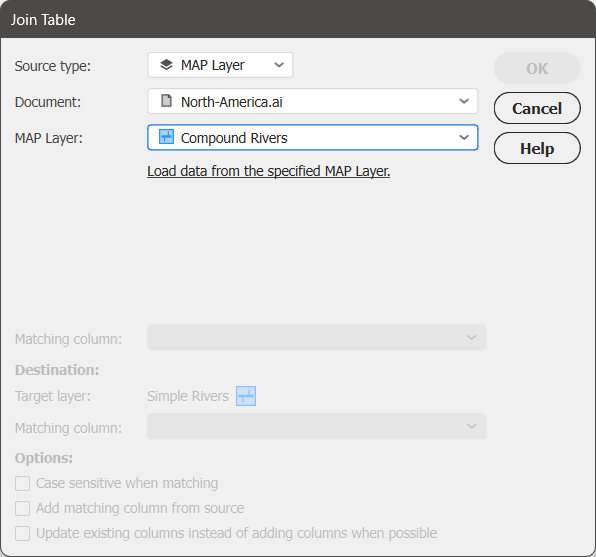
Join Table from existing MAP Layer: Users can now use the Join Table feature in the MAP Attributes panel to join tables from existing MAP Layers using the “Source Type” drop-down list. These layers may be contained within the active document or any other currently open document.
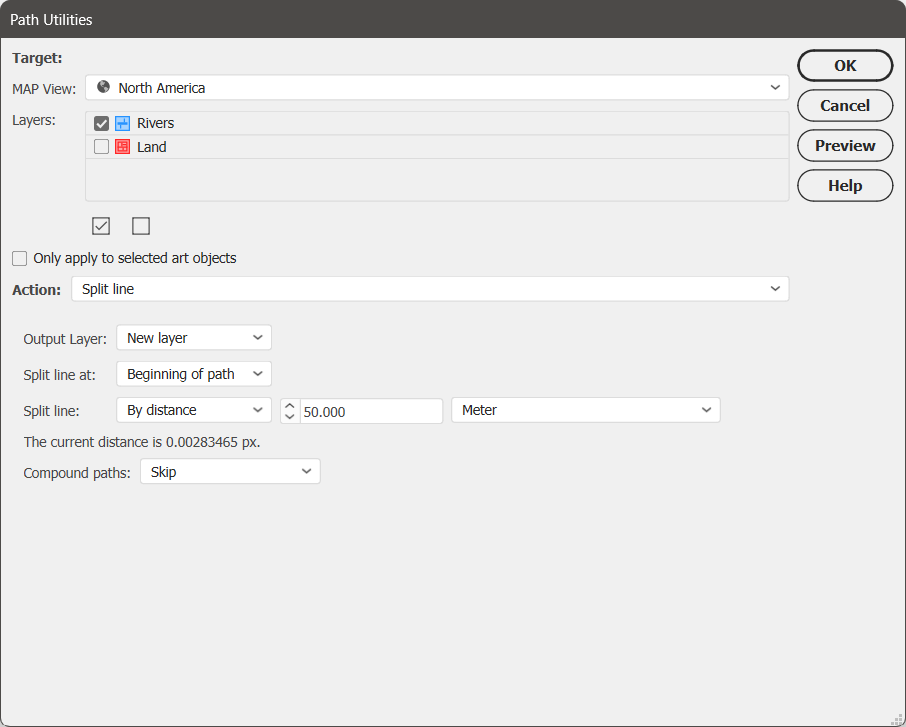
Split Line action added to Path Utilities menu: The Split Line utility splits a selection of lines into two separate segments at a certain specified length, which can be either relative (i.e. as a percentage of the total line length) or absolute (i.e. at a specified distance in selected units).
Performance enhancements: MAPublisher v11.5 has improved performance when working with files containing a large number of features and attributes. Users can expect improved performance in multiple areas including coordinate system reprojection, applying stylesheets, deleting art, moving art between layers, and splitting layers.
Additional performance improvements and bug fixes
Users require a valid Adobe Creative Cloud subscription and a compatible operating system to utilize the improvements and enhancements offered in MAPublisher v11.5. For questions and information on how compatibility requirements may affect your organization, please contact our Support Centre.
MAPublisher v11.5 is immediately available free of charge to all current MAPublisher users with active maintenance and as an upgrade for non-maintenance users starting at US$739. New licenses are available from US$1,699. MAPublisher FME Auto and MAPublisher LabelPro are also available as add-ons starting at US$569. Academic, floating, and volume licenses are also available. Prices include one year of full maintenance. Visit www.avenza.com/mapublisher for more details.
More about Avenza Systems Inc.
Avenza Systems Inc. is an award-winning, privately held corporation that provides cartographers and GIS professionals with powerful software tools to make better maps. Avenza also offers the mobile Avenza Maps app to sell, purchase, distribute, and use maps on iOS and Android devices. For further information contact: 416-487-5116 – info@avenza.com – www.avenza.com
We are excited to announce the release of MAPublisher version 11.5, the latest update to our MAPublisher extension for Adobe Illustrator.
MAPublisher v11.5 introduces several compatibility upgrades, support for importing vector basemaps from custom tile sources, new functionality for using the Join Table feature with existing MAP Layers, a new Split Line path utility, and other performance improvements and bug fixes.
Here’s what you can expect with the latest MAPublisher v11.5 release:
Compatibility upgrades
We’ve been hard at work this fall, and we’re delighted to share that MAPublisher 11.5 is fully compatible with Adobe Illustrator 2025 (version 29), which was released this October. MAPublisher 11.5 also supports the newly launched macOS Sequoia (version 15) and FME Form 2024 (version 2024.1).
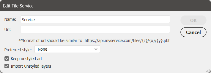
Import Vector Basemaps from custom tile sources
We’ve heard your requests and are thrilled to announce that MAPublisher now supports importing Vector Basemaps from PBF file-based custom tile sources like Mapbox, Esri, and OpenStreetMap! You can access this feature under the “Service” option within the Import Vector Basemaps dialog box. You can add your service by clicking the green plus/+ button next to the drop-down list. This will open up a new window called “Edit Tile Service” where you can give your service a name, provide its URL, set a preferred style if desired, and select whether or not you wish to import unstyled art.
You might also notice that the Configure Vector Basemaps option has moved from the Vector Basemaps button on the MAP Toolbar to its own dedicated button, “MAP Basemap Styling,” located under Thematic Tools.
Visit our Vector Basemaps support page for more detailed information on importing vector basemaps from custom tile sources, including URL formatting!
Join Table now supports tables from existing MAP Layers
The Join Table tool—available from the MAP Attributes panel—has also been enhanced with new functionality in MAPublisher 11.5. The “Source type” option now lets you select either an external file or the new “MAP Layer” option, enabling you to join tables directly from an existing MAP Layer. This layer can be sourced from within your active document or any other currently open document in Illustrator.
Split Line action added to Path Utilities
Split Line is a new option added to the Action menu of the Path Utilities tool. This action splits a selection of lines into two separate segments at a specified length. This length can be measured from either end of the line and can be set as either relative (i.e. as a percentage of the total line length) or absolute (i.e. at a specified distance in selected units).
The Split Line action is an ideal solution for tapering only the endpoints of lines, such as at river mouths. This circumvents the limitation of Illustrator’s native Stroke properties, which automatically taper paths evenly from start to end. With this utility, you also have the option to store the output in a New Layer, allowing for easy selection and batch styling of all end segments.
Other performance improvements
Lastly, you can expect to see improved performance in the following areas:
Improved order of operations on import
In MAPublisher 11.5, we have fixed an issue where data was being simplified before any spatial filtering was applied. Now, the spatial filter is applied first, and art is only simplified if the remaining data exceeds Illustrator’s limit of 32,000 points per path.
Attribute table and projection performance improvements
You should also look for smoother and quicker software performance when working with files containing a large number of features and attributes. These enhancements can be seen in multiple areas, including coordinate system reprojection, applying stylesheets, deleting art, moving art between layers, and splitting layers!
MAPublisher 11.5 is Available Now!
If you would like to learn more about the new MAPublisher v11.5 features or have any questions, please check out our Support Centre.
MAPublisher v11.5 is immediately available today, free of charge to all current MAPublisher users with active maintenance subscriptions and as an upgrade for non-maintenance users. Download here.
Toronto, ON, July 30, 2024 – Avenza Systems Inc., producers of the Avenza Maps® app for mobile devices and geospatial extensions for Adobe Creative Cloud®, including Geographic Imager® for Adobe Photoshop®, is pleased to announce the release of MAPublisher® version 11.4 for Adobe Illustrator®. This version introduces a newly reworked Create Knockouts tool, importing Vector Basemaps within a selected area, WMS 1.3.0 import support, a new Rotate Characters text utility, a preference to convert RGB black to 100K black in CMYK documents, setting a leader line offset with the MAP Tagger tool, and several performance updates and bug fixes.
MAPublisher cartography software seamlessly integrates more than seventy GIS mapping tools into Adobe Illustrator to help you create beautiful maps from geospatial data. Import industry-standard GIS data formats and make crisp, clean maps with all attributes and georeferencing intact using the Adobe Illustrator design environment.
New features of MAPublisher v11.4 for Adobe Illustrator include:
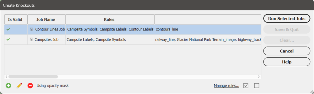
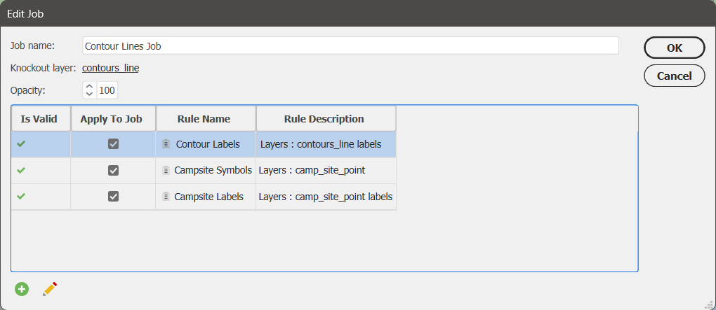
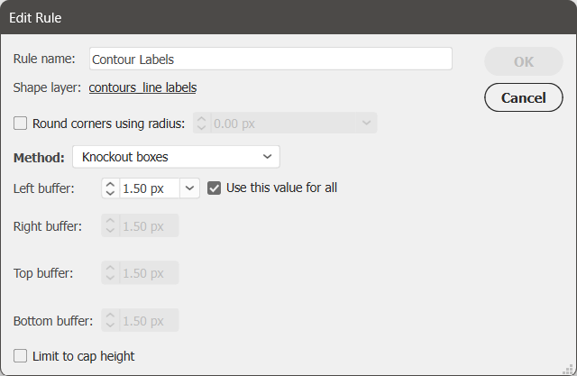
Reworked Create Knockouts tool: Create Knockouts tool features an improved architecture which introduces knockout settings saved as jobs and rules, which allow users to create knockouts for multiple layers simultaneously and easily transfer settings between documents
Importing Vector Basemaps within a selected area: Vector Basemap data can now be imported to a document in a selected area as long as it is a closed shape, does not overlap itself, and is within the current MAP View
WMS 1.3.0 import capabilities: MAPublisher now supports the import of data from Web Map Service (WMS) version 1.3.0, with an option to autodetect the WMS version added
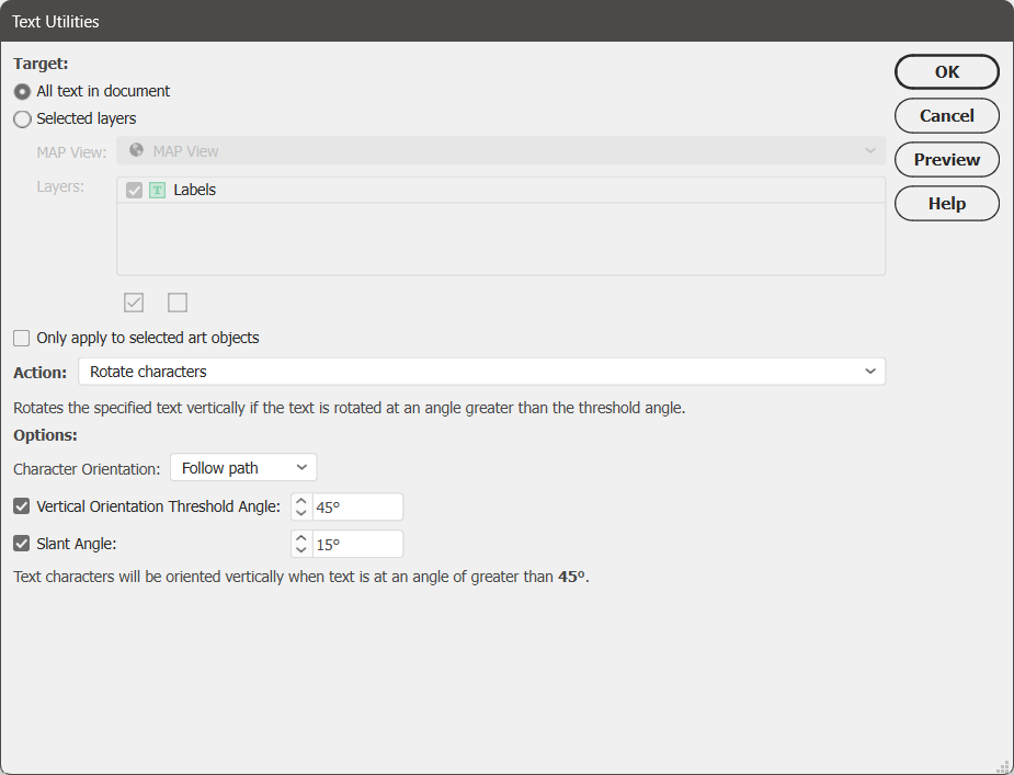
Rotate Character action added to Text Utilities menu: Rotate Characters allows users to specify character rotation settings for point text located within their map document
Convert RGB Black to 100K Black preference: MAPublisher Preferences menu now features the option to convert RGB black to 100K black (rather than rich, or 4-colour black) for CMYK documents to prevent a printing issue known as “ghosting”; this option is enabled by default
Offset from Feature option for leader lines in MAP Tagger tool: MAP Tagger tool now features a new option in the Leader Lines Settings tab under the Rules section to set an “Offset from feature” distance to prevent leader lines from obscuring map features when labeling them
Additional performance improvements and bug fixes
Users require a valid Adobe Creative Cloud subscription and a compatible operating system to utilize the improvements and enhancements offered in MAPublisher v11.4. For questions and information on how compatibility requirements may affect your organization, please contact our Support Centre.
MAPublisher 11.4 is immediately available free of charge to all current MAPublisher users with active maintenance and as an upgrade for non-maintenance users starting at US$739. New licenses are available from US$1,699. MAPublisher FME Auto and MAPublisher LabelPro are also available as add-ons starting at US$569. Academic, floating, and volume licenses are also available. Prices include one year of full maintenance. Visit www.avenza.com/mapublisher for more details.
More about Avenza Systems Inc.
Avenza Systems Inc. is an award-winning, privately held corporation that provides cartographers and GIS professionals with powerful software tools to make better maps. Avenza also offers the mobile Avenza Maps app to sell, purchase, distribute, and use maps on iOS and Android devices. For further information contact: 416-487-5116 – info@avenza.com – www.avenza.com
We are thrilled to announce the release of MAPublisher version 11.4, the newest version of our MAPublisher extension for Adobe Illustrator.
MAPublisher v11.4 introduces a newly reworked Create Knockouts tool, importing Vector Basemaps within a selected area, WMS 1.3.0 import support, a new Rotate Characters text utility, a preference to convert RGB black to 100K black in CMYK documents, setting a leader line offset with the MAP Tagger tool, and several performance updates and bug fixes.
Here’s what you can expect with the latest MAPublisher v11.4 release:
The Create Knockouts tool has a new design!
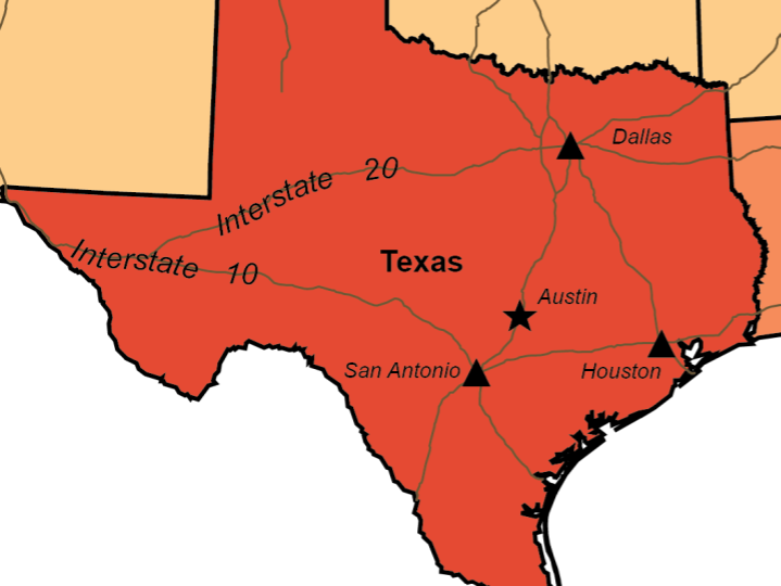
We are excited to introduce you to the new version of the Create Knockouts tool. Create Knockouts is a tool that allows you mask off parts of features that may be covered by things such as text or points. The aim of this tool is to increase the readability of your map, especially in areas where features may overlap or look cluttered.
Without knockouts
With knockouts
The previous version of the Create Knockouts tool only consisted of a single dialog box. This had the limitation of allowing knockouts to be created around only a single layer at a time, meaning that multiple iterations of the tool had to be run to create knockouts for several different layers. This also meant that correcting mistakes or modifying existing knockouts required the tool to be run again, which could be frustrating or time consuming.
The new version of the Create Knockouts tool features an improved tool architecture which introduces knockout settings stored as jobs and rules. Jobs and rules allow knockouts to be created simultaneously for multiple layers.
A job defines which layers are being masked and consists of one or more rules that will be used to form the knockouts.
A rule defines the overall appearance of the knockouts and which layers the knockouts will be formed around.
One very useful thing about jobs and rules is that they are also transferable to your other map documents through the use of the Copy MAP Objects From tool.
The introduction of jobs and rules to the Create Knockouts tool makes it much easier for you to create multiple batches of knockouts at once while also being able to save their settings. This is very convenient if you come back later and wish to make modifications to your knockouts as your map evolves through its creation.
To learn more about how the new edition of the Create Knockouts tool works, check out its support page or watch the video below:
Import Vector Basemaps within a selected area
The Vector Basemaps tool is also receiving a small but significant update in MAPublisher v11.4: you can now import basemap data to your document only in a specific area! This option is available in the Import Vector Basemaps dialog box by way of selecting the “Only import data within the selected area” checkbox when you are selecting data for an existing MAP View. However, for this checkbox to be selectable it does require the following conditions to be met:
The selected area must be a single shape or compound path
The selected area must be closed
The selected area must not overlap itself
The selected area must be located within the current MAP View
This new option for the Vector Basemaps tool is perfect for the quick creation of interestingly shaped inset maps!
Import data from WMS 1.3.0
Many of our users have requested the ability to be able to import data from Web Map Service (WMS) version 1.3.0 and we are happy to announce that this is now possible in MAPublisher v11.4! Simply follow the usual steps to add a web map service and select 1.3.0 from the Version drop-down menu. We have also added an “Autodetect Version” option in this menu which can detect the WMS version used by the URL provided.
Rotate Characters action added to Text Utilities
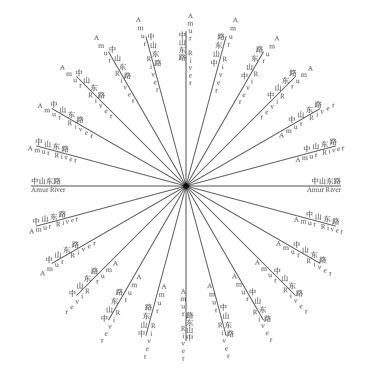
Rotate Characters is a new option that has been added to the Action menu of the Text Utilities tool. This action only applies to point text, not text-on-a-path. It introduces the option to select whether your characters are oriented to follow the direction of the path, or point upwards. It also gives users the option to set a vertical orientation threshold angle, which determines which text elements will be rotated vertically, and/or set a slant angle, which will rotate characters within a text element.
The Rotate Characters text utility action is a great way to increase readability of the text objects of a map and is especially useful for languages that require properly rotated characters to be more understandable, such as Chinese. Below is a basic illustration of the new feature.
Convert RGB black to 100K black upon import in CMYK mode
In CMYK documents, RGB black features are often converted to rich black (i.e. 4-colour black) instead of 100K black, which can cause an issue known as “ghosting” when printing features that require fine detail such as small text and lines. Ghosting is when tiny variations in the printing plate produce blurry remnants of the 4 colours around the edges, as seen below.
To help printed map-makers easily avoid ghosting, a new option has been added to MAPublisher Preferences in the Import Map Data section to “Convert RGB Black to 100K Black” for CMYK documents. This option will be enabled by default.
Specify a leader line offset when using MAP Tagger
When using the MAP Tagger tool, the option to specify an offset between the leader line and the feature has been added in the “Leader Line Settings” tab under the Rules section. Select the “Offset from feature” checkbox and set an offset distance. This can be used to ensure that the created leader line does not obscure the feature you are labeling.
MAPublisher 11.4 is Available Now!
If you would like to learn more about the new MAPublisher v11.4 features or have any questions, please check out our Support Centre.
MAPublisher v11.4 is immediately available today, free of charge to all current MAPublisher users with active maintenance subscriptions and as an upgrade for non-maintenance users.