Toronto, ON, August 11, 2005 – Avenza Systems Inc., producers of MAPublisher cartographic software, announces that the University of Illinois at Urbana-Champaign has chosen MAPublisher software for use in the Department of Urban & Regional Planning computer laboratory.
“We are very pleased that MAPublisher is now available for our students to use” said Varkki George Pallathucheril, Associate Professor of Urban and Regional Planning at the University of Illinois at Urbana-Champaign. “We tested MAPublisher in a course and found that students learned to use it without difficulty to produce high-quality maps using digital spatial data. By providing access to MAPublisher we expect to realize significant benefits in the classroom and when our students become professional planners“, he added.
MAPublisher will be primarily used in the department’s state-of-the-art instructional computer laboratory.
More about MAPublisher
MAPublisher is powerful map production software for creating cartographic-quality maps from GIS data. Developed as a suite of plug-ins for Adobe Illustrator and Xtras for Macromedia Freehand, MAPublisher leverages the superior graphics editing capabilities of these applications with the strength and power of GIS data. Full details and downloadable demo versions are available at www.avenza.com.
More about Avenza Systems Inc.
Avenza Systems Inc. is a privately held, award-winning supplier of powerful map-making software and affordable geodata products. Led by its flagship MAPublisher product for Adobe Illustrator and Macromedia Freehand and new Geographic Imager suite for Adobe Photoshop, Avenza has brought GIS and geographic workflows to the mainstream graphics and imaging environments. The Company also offers product training and consulting services. Visit www.avenza.com for more details.
More about the Department of Urban and Regional Planning at the University of Illinois at Urbana-Champaign
With a long history and tradition in planning education focused on land use and the physical development of communities to achieve social and environmental goals, the Department of Urban and Regional Planning at the University of Illinois at Urbana-Champaign (http://www.urban.uiuc.edu/) responds to these needs. Emphasizing the analysis and interpretation of data to devise and implement plans, the programs of study integrate a natural science component with a strong social science component. The Department’s programs are designed to educate persons who can plan effectively in a variety of institutions—public planning agencies, private development corporations, or neighborhood organizations. The Department is one of only two departments in the United States to offer accredited professional degrees in planning at the bachelor and master levels and a PhD.
For further information:
Tel: 416-487-5116
Email: info@avenza.com
Web: www.avenza.com
August, 2005. In this second segment of his online series, From GIS to the Desktop, author Steve Gordon of Cartagram LLC, further discusses using Adobe Illustrator and MAPublisher to create great looking map products.
“My first article in this series, From GIS to the Desktop, explored the visual and production value of taking GIS data and maps to desktop software like Adobe Illustrator. The visual effects you can elicit in desktop software will make the trip rewarding – your maps will communicate more effectively, your clients will be more pleased with the richness of your proofs and prints, your files will be more portable, and you may discover new ways of symbolizing map data along the way. How do you travel from GIS to the desktop, quickly and affordably? […] you import, edit and perform various GIS operations on your data before exporting files in a GIS format that you then import into Illustrator as data. This packs your attributes and georeferencing information in case you need to access or manipulate it using the Avenza MAPublisher plug-ins during final map production…”
Powerful software suite adds geospatial functionality to Adobe Photoshop
Toronto, ON, July 25, 2005 – Avenza Systems Inc., producers of MAPublisher cartographic software for Adobe Illustrator and Macromedia FreeHand as well as MAPdataUSA and MAPdataWorld royalty-free data sets, announces Geographic Imager, a new plug-in suite for Adobe Photoshop that adds geospatial functionality to this powerful image editing program.
Geographic Imager enhances the already commanding Adobe Photoshop imaging environment by adding all the tools and technology necessary to support the import, edit, manipulation and export of geospatial images such as aerial and satellite imagery. In addition to allowing the use of Photoshop’s numerous native imaging functions such as transparencies, cropping, individual pixel editing and brightness/contrast control, Geographic Imager adds the ability to import and recognize geotiffs and other referenced raster formats, automatically mosaic images spatially, reproject images, transform and geo-reference images based on ground control points and re-export images with all spatial information intact.
“We have answered the call of spatial imagery users worldwide by extending the dominant image editing environment of Adobe Photoshop to the GIS realm,” said Ted Florence, President of Avenza, “Geographic Imager is the next evolutionary step in bringing geospatial image editing to the masses and is the perfect companion suite for MAPublisher.” he added.
Features and Benefits of Geographic Imager
Allows the use of Adobe Photoshop native functionality without destroying the spatial properties of the image
Import geotiffs and other spatial raster formats along with all georeferencing
Export geotiffs and other spatial raster formats
Georeference non-referenced imagery
Ground Control Point (GCP) transformation
Reprojection of spatial imagery
Automatic mosaicking of spatial imagery
Adobe Photoshop CS2 compatible
Mac and Windows versions available
Floating licensing option availability
More about Geographic Imager
Geographic Imager is powerful software for working with spatial imagery in Adobe Photoshop that leverages the superior image editing capabilities of this raster-based image-editing software. Geographic Imager will begin shipping in the fall of 2005 and will be priced at US$599 for a single-user fixed commercial license. MAPublisher maintenance program members will enjoy a US$100 time-limited discount. Educational and floating licenses as well as discounted MAPublisher/ Geographic Imager bundles will also be available. Full details are available at www.avenza.com.
More about MAPublisher
MAPublisher is powerful map production software for creating cartographic-quality maps from GIS data. Developed as a suite of plug-ins for Adobe Illustrator and Macromedia Freehand, MAPublisher leverages the superior graphics capabilities of these design packages.
More about Avenza Systems Inc.
Avenza Systems Inc. is an award winning corporation that provides cartographers and GIS professionals with powerful software tools for making better maps. In addition to software offerings for Mac and Windows users, the Company offers value-added data sets, product training and consulting services. Visit www.avenza.com for more details.
For further information:
Tel: 416-487-5116
Email: info@avenza.com
Web: www.avenza.com
Toronto, ON, June 27, 2005 – Avenza Systems Inc., the developer of MAPublisher map production software, announces the 2005 MAPublisher Map Awards. This competition is a forum for MAPublisher users to showcase their work, receive recognition, share ideas and compare their productions with other MAPublisher users from around the world.
“We are very pleased to hold this awards event once again,” said Ted Florence, president of Avenza Systems Inc. ”Last year we again saw some tremendous examples of what MAPublisher can empower a user to create and we look forward to just as exciting a selection of entries this year,” he added.
A copy of all maps received for this year’s competition will also be forwarded to The Map Division of the Library of Congress in Washington, DC to be added to the MAPublisher collection established in 2003.
More about the MAPublisher Map Awards
The competition is open to all maps created with MAPublisher. Awards will be presented for the map judged as the best in each category along with a grand prize for the Best Map Overall. In the academic category the winning entrant with also be awarded a free license of the MAPublisher version of their choice that they may use to either expand or upgrade their existing MAPublisher working environment.
List of Categories
Best Map Overall
Best Thematic Map
Best Topographic Map
Best Transportation Map
Best General Purpose Map
Best Special Purpose Map
Best Geologic Map
Best Multimedia Map
Best Academic Map
Best Map Collection
Submissions will be accepted until September 2nd, 2005 midnight EST. Winners will be announced by or on October 15th, 2005.
Full competition details are available at www.avenza.com/MPcomp/ or by emailing competition@avenza.com.
More about MAPublisher
MAPublisher is powerful map production software for creating cartographic-quality maps from GIS data. Developed as a suite of plug-ins for Adobe Illustrator and Macromedia Freehand, MAPublisher leverages the superior graphics capabilities of these design packages.
More about Avenza Systems Inc.
Avenza Systems Inc. is an award winning corporation that provides cartographers and GIS professionals with powerful software tools for making better maps. In addition to software offerings for Mac and Windows users, the Company offers value-added data sets, product training and consulting services. Visit www.avenza.com for more details.
Summer, 2005. In this quarter’s Society for News Design Journal, Catherine Farley, deputy graphics director at the Toronto Star newspaper, discussed how the newspaper’s graphics department used MAPublisher and Adobe Illustrator to quickly and easily produce maps for the 2004 US and Canadian federal elections.
“We knew we were on to something when election night editors were using our proofs as road maps for their stories…..We also knew we would not have time to color the map manually so we used MAPublisher to automate the process.”
Toronto, ON, May 25, 2005 – Avenza Systems Inc., producers of MAPublisher cartographic software and MAPdataUSA and MAPdataWorld GIS data products, is pleased to announce that it will support HarrysMaps of Switzerland and the Regional Centre for Mapping of Resources for Development (RCMRD) project to remap the city of Nairobi, Kenya.
Along with other supporters such as P’Auer Printing Inc, Adobe Systems Inc. and Yupo Europe GmbH, Avenza will provide software and services free of charge to this not-for-profit project whose ultimate goal is to provide local decision makers, authorities, investors and tourists with handy, high quality paper maps for daily use.
“MAPublisher will play an important role in the creation of the high-quality maps, set as our ultimate goal for this project” said Harry Keller of HarrysMaps, the chief cartographer and project supervisor. “We are all well aware of MAPublisher’s ability to easily and effortlessly create great maps and we are very pleased and thankful for Avenza’s support for this project”, he added.
MAPublisher will be used in the cartographic design and production work using data derived from the RCMRD’s processing of satellite imagery to create the most up-to-date GIS database possible.
“Avenza is always willing to support worthwhile projects in the developing world such as this one in Nairobi” said Ted Florence, President of Avenza. “We are pleased that MAPublisher will be used in this important project and we applaud the RCMRD’s endeavour to generate this new database and HarrysMaps’ initiative to produce the map for the city”, he added.
More about MAPublisher
MAPublisher is powerful map production software for creating cartographic-quality maps from GIS data. Developed as a suite of plug-ins for Adobe Illustrator and Xtras for Macromedia Freehand, MAPublisher leverages the superior graphics editing capabilities of these applications with the strength and power of GIS data. Full details and downloadable demo versions are available at www.avenza.com.
More about Avenza Systems Inc.
Avenza Systems Inc. is an award-winning, privately held corporation that provides cartographers and GIS professionals with powerful software tools for making better maps. In addition to software offerings for Mac and Windows users, Avenza offers value-added data sets, product training and consulting services. Visit www.avenza.com for more details.
More about the Regional Centre for Mapping of Resources for Development
The Regional Centre for Mapping of Resources for Development was established in Nairobi, Kenya in 1975 under the auspices of the United Nations Economic Commission for Africa (UNECA) and the then Organization of African Unity (OAU). It is a non-profit intergovernmental organization that currently has 14 member states in southern and eastern Africa. The centre’s main objectives are: to provide services in the fields of surveying, and mapping; to provide training for nationals of member states in surveying, mapping and remote sensing; and to provide advisory services on matters relating to surveying and mapping. More information can be found on the organization’s website at www.rcmrd.org
For further information:
Tel: 416-487-5116
Email: info@avenza.com
Web: www.avenza.com
Powerful mapmaking software now supports Adobe Illustrator Creative Suite 2
Toronto, ON, May 17, 2005 – Avenza Systems Inc., producers of MAPublisher cartographic software, and MAPdata USA, MAPdata World and MajorCities USA royalty-free GIS/cartographic data files, announces the release of MAPublisher 6.2.
MAPublisher 6.2 is the latest version of this powerful mapmaking software used to produce high quality maps from GIS data ensures compatibility with the new Adobe Creative Suite 2 (CS2) that was released earlier this month. All earlier versions of MAPublisher are not compatible with Illustrator CS2.
“The timely release of MAPublisher 6.2 (so soon after Adobe began shipping) is demonstrative of our continuing commitment to keep pace with the new releases from Adobe,” said Ted Florence, president of Avenza Systems. “We are also pleased to have taken this opportunity to include new functionality in response to customer requests”, he added.
In addition to being compatible with Adobe Illustrator CS2, CS and 10, MAPublisher 6.2 adds the ability to simultaneously export multiple Illustrator map layers to GIS data formats. Previous versions could only export single layers at a time.
MAPublisher 6.2 for Adobe Illustrator is a full product update that is free to all current MAPublisher Maintenance Program subscribers and replaces the current shipping version of MAPublisher 6.1 for all new customers. All other customers, including MAPublisher 6.x customers with expired maintenance, will be required to purchase this upgrade at the usual upgrade price. MAPublisher for FreeHand users can crossgrade for US$200 if they have maintenance or US$599 if they do not.
More about MAPublisher for Illustrator
MAPublisher for Illustrator is powerful map production software for creating cartographic-quality maps from GIS data. Developed as a suite of plug-ins for Adobe Illustrator, MAPublisher leverages the superior graphics capabilities of this graphics design software. Avenza also offers MAPublisher 5.0 for FreeHand – a suite of Xtras that add mapmaking functionality to Macromedia Freehand 10 and MX. Full details are available at www.avenza.com.
More about Avenza Systems Inc.
Avenza Systems Inc. is an award-winning, privately held corporation that provides cartographers and GIS professionals with powerful software tools for making better maps. In addition to software offerings for Mac and Windows users, Avenza offers value-added data sets, product training and consulting services. Visit www.avenza.com for more details.
For further information:
Tel: 416-487-5116
Email: info@avenza.com
Web: www.avenza.com
Toronto, ON, April 25, 2005 – Avenza Systems Inc., producers of MAPublisher cartographic software, announces that the Department of Earth Sciences at the University of Hong Kong, Hong Kong S.A.R., has chosen MAPublisher software for use in their remote sensing laboratory.
“MAPublisher will play an important role in the creation of high-quality maps within our department” said Prof. Jonathan Aitchison, Head of the Department of Earth Sciences at the University of Hong Kong. “We feel that good map creation and cartography are important to any geographic or geologic exercise and we are excited about using MAPublisher to enhance those skills at our school”, he added.
MAPublisher will be primarily used in the Remote Sensing Laboratory. Staff and students, particularly those working on the geodynamics of Eastern Asia, will be able to take advantage of the graphics capabilities of MAPublisher to produce high-quality maps.
More about MAPublisher
MAPublisher is powerful map production software for creating cartographic-quality maps from GIS data. Developed as a suite of plug-ins for Adobe Illustrator and Xtras for Macromedia Freehand, MAPublisher leverages the superior graphics editing capabilities of these applications with the strength and power of GIS data. Full details and downloadable demo versions are available at www.avenza.com.
More about Avenza Systems Inc.
Avenza Systems Inc. is a privately held, award-winning supplier of powerful map-making software and affordable geodata products. The Company also offers product training and consulting services. Visit www.avenza.com for more details.
More about the Department of Earth Sciences at the University of Hong Kong
The Department of Earth Sciences was recently established at the University of Hong Kong and is ideally situated on the margin of east Asia. Opportunities exist to undertake genuinely new research into the tectonic evolution of both ancient and modern orogenic systems in this fascinating area. The subtropical location and local geology of Hong Kong present significant challenges and employment opportunities for engineering and environmental geologists and are another major focus of the department.
For further information:
Tel: 416-487-5116
Email: info@avenza.com
Web: www.avenza.com
Powerful mapmaking software for Adobe Illustrator is now accessible via the Internet
Toronto, ON, April 19, 2005 – Avenza Systems Inc. is pleased to announce the immediate availability of Internet-accessible floating or networked licenses of MAPublisher 6 for Adobe Illustrator. MAPublisher 6 is feature-rich mapmaking software used to produce high quality maps from GIS data and the addition of Internet-accessible floating licenses make this powerful cartographic production environment even more efficient and workgroup-friendly. This new license format allows access to MAPublisher and all its functionality via remote access to a Windows, Mac or Linux server host using a normal Internet connection. It provides the perfect solution for users who travel, work offsite and/or for workgroups composed of decentralized personnel.
“The introduction of MAPublisher 6 floating licenses last year marked an exciting new era in MAPublisher licensing and we are now equally as excited to provide this new approach to software sharing.” said Ted Florence, president of Avenza Systems, “The MAPublisher Internet Floating license makes MAPublisher much more productive in small or large multi-user or multi-computer environments where all users are not in the same physical location and helps lower the overall deployment cost in such organizations.” he added.
Floating licenses are a wonderful cost-effective way of sharing software amongst multiple users in a networked environment and should be considered for any MAPublisher user environment in which more than one person uses MAPublisher or in which it is desired that more than one person has access to MAPublisher. Floating licenses are particularly useful for companies or academic labs with multiple users wherein not everyone uses the product at the same time. The MAPublisher Internet Floating License has all the features and benefits of a normal networked or floating license along with the added ability to remotely access it via the Internet.
MAPublisher is powerful map production software for creating cartographic-quality maps from GIS data. Developed as a suite of plug-ins for Adobe Illustrator and Macromedia Freehand, MAPublisher leverages the superior graphics editing capabilities of these applications with the strength and power of GIS data. Full details and downloadable demo versions are available at www.avenza.com.
Features/Benefits of MAPublisher Internet Floating Licenses
All the features and functionality of MAPublisher 6 for Adobe Illustrator are included.
Access to the software via a remote Internet connection
Empower multiple users and/or multiple computers without the cost of purchasing an individual specific license for each user or computer.
Allows MAPublisher to be shared among an unlimited group of potential users. The actual MAPublisher client software can be installed on an unlimited number of computers and can be used on any combination of computers concurrently, up to a maximum set by the number of floating licenses purchased.
Supports Windows, Mac and Linux servers.
Supports mixed platform (Windows and Mac) client environments.
Special laptop option enables users to borrow a license and take it on the road even when disconnected from the network.
Additional client computers and/or users can be added at no extra cost.
More about MAPublisher 6 for Illustrator Floating Licenses
MAPublisher 6 for Illustrator is powerful map production software for creating cartographic-quality maps from GIS data. Developed as a suite of plug-ins for Adobe Illustrator 10 and CS, MAPublisher 6 leverages the superior graphics capabilities of this design software package. Avenza also offers MAPublisher 5 for FreeHand – a suite of Xtras that adds mapmaking functionality to Macromedia Freehand 10 and MX.
MAPublisher floating licenses are available now directly from Avenza Systems or through the Avenza reseller network at prices ranging from US$1799. Internet-enable floating licenses start at US$1999. Users may also upgrade from fixed to floating licenses. Prices include 1 year of maintenance. Customers who purchase a MAPublisher floating license on or before May 31, 2005 will receive a free upgrade to the Internet-enabled version. Full details are available at www.avenza.com.
More about Avenza Systems Inc.
Avenza Systems Inc. is an award-winning, privately held corporation that provides cartographers and GIS professionals with powerful software tools for making better maps. In addition to software offerings for Mac and Windows users, Avenza offers value-added data sets, product training and consulting services. Visit www.avenza.com for more details.
For further information:
Tel: 416-487-5116
Email: info@avenza.com
Web: www.avenza.com
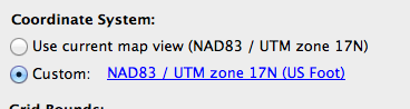
In a previous blog about Grids and Graticules, we quickly introduced one of the major features of the new Grid and Graticule tool. We’d like to share another major feature when creating grids: creating grids with an alternative coordinate system.
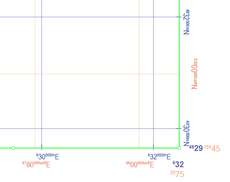
For example, the MAP View has a coordinate system “NAD 83 / UTM zone 17N” (in metres). You might want to make grid lines with the same coordinate system but in different units. You can do so by creating a custom coordinate system and then specifying the desired unit (US Foot, for this example), then creating a grid based on custom coordinate system. In this example, a grid with NAD83/UTM zone 17N (metres) coordinate system is created in the blue colour. Another grid with a NAD83/UTM zone 17N (USFoot) custom coordinate system is created with the orange colour.
Likewise, you can create multiple sets of measured grids with different coordinate systems in one MAP View (e.g. one set with NAD83 UTM, another with NAD27 UTM, another with some other local coordinate system) without the need to transform the MAP View.
Currently, MAPublisher and Geographic Imager are NOT officially compatible with macOS Tahoe. To avoid any potential issues, please refrain from updating to macOS Tahoe at this time.