Avenza Maps version 3.7 is now available for users on iOS and Android devices! We have added features for both our recreational and Pro subscription users and made some improvements based on user feedback. The newest version of Avenza Maps includes features that will facilitate location monitoring, improve the precision of your data collection and enhance your Avenza Maps experience!
Geofences
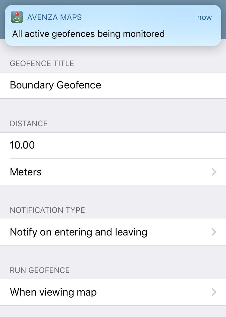
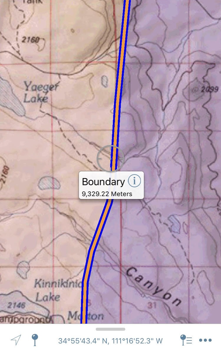
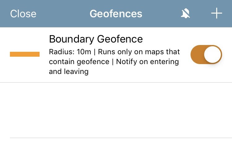
New in Avenza Maps 3.7, is Geofencing. These are virtual perimeters or boundaries that are set up around a geographic location. When you approach or leave one of the boundaries, the app triggers a notification on your device. You have the option to create geofences around features in any map including placemarks, tracks, lines, areas, layers, and even the map itself.
Geofences act as a location monitoring tool in order to keep track of your location without needing your phone in your hand at all times! With global geofence notification capability (a Pro feature), you can ensure that you never miss an alert because regardless of the map you have open, your global geofence will always be active.
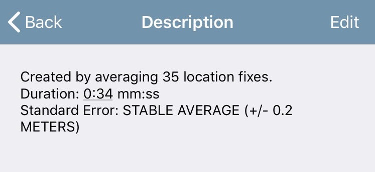
Plot GPS Average
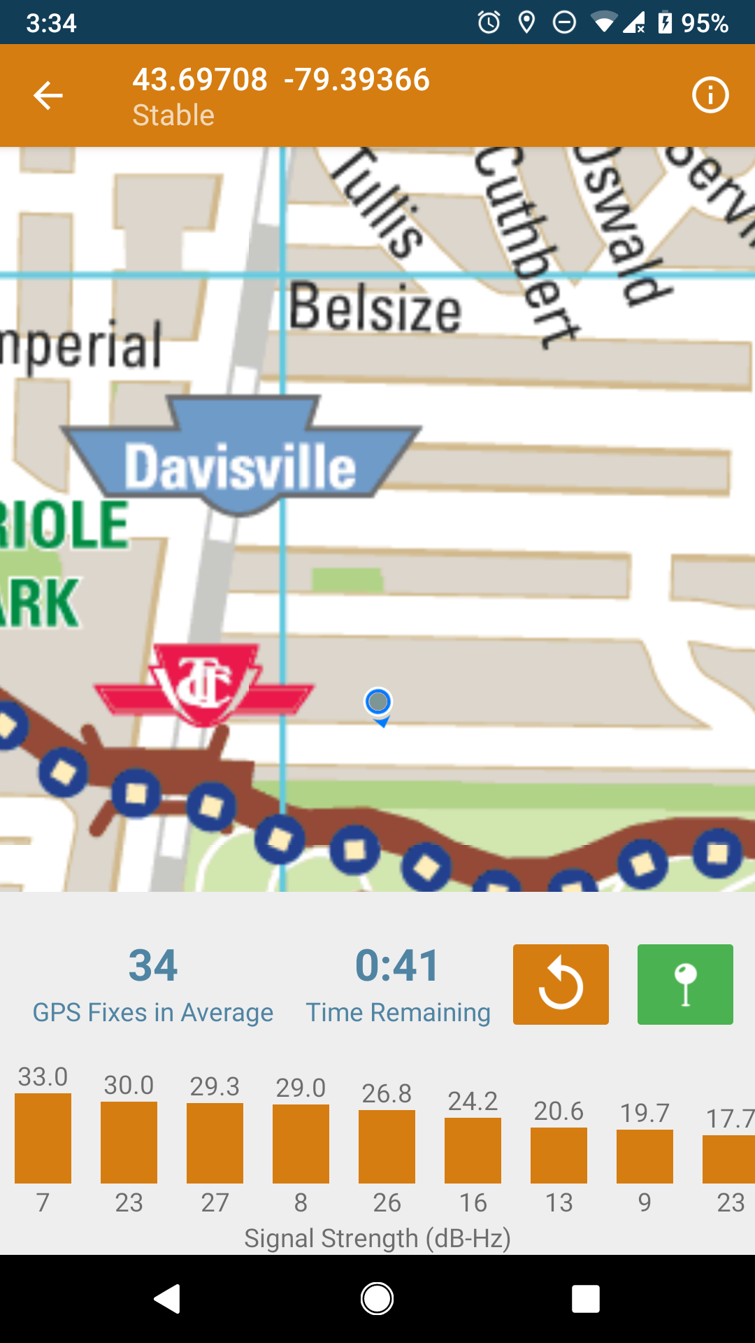
Pro users can increase the integrity and precision of location data by using the new Plot GPS Average tool to plot placemarks. The tool works by sampling your location over a period of time then deriving the average of the location samples and plotting a placemark on the map.
Map Versions
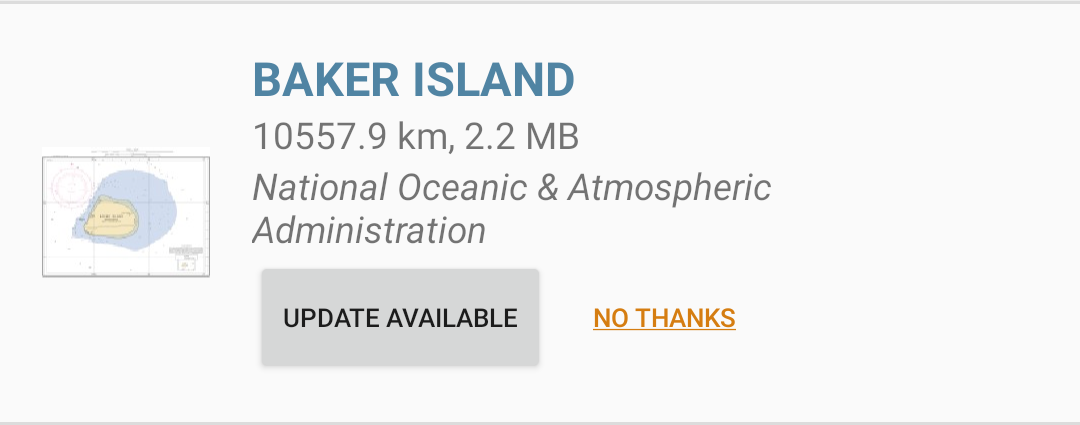
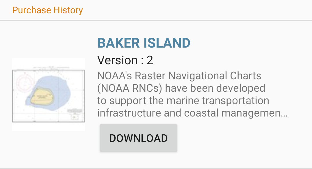
Avenza Map Store Publishers can now release updates directly to their existing products! Now when an update to one of your previously downloaded maps is released by the publisher, you will be notified in the app and prompted to install the newest version. The notification will appear as a button under the current map that says Update Available. We recommend updating your maps but if you would prefer not to, you can decline the upgrade and the update option disappears.
Any map data linked to the previous version will transfer to the new version of the map. So, if for example, you have a trail map that you use to collect your tracks or plot placemarks, you won’t lose a thing!
There are some big changes and improvements in this version of the app and we’re very excited about it. Our goal is always to ensure that Avenza Maps users can navigate safely and efficiently and collect data even more precisely in the app!
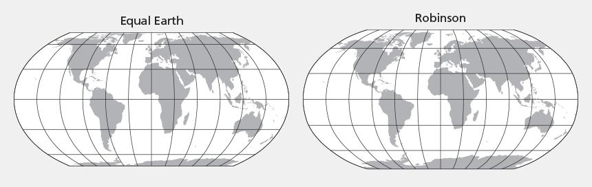
We released an update today, to MAPublisher, our well-known cartography plug-in for Adobe Illustrator. This version features support for the Equal Earth projection, has a new look and feel that more closely matches Adobe Illustrator’s interface and includes new options for importing geospatial data into Illustrator.
Equal Earth Projection
Our partners, Blue Marble Geographics, have added the Equal Earth Projection to their GeoCalc library, the system that we use for data reprojection and coordinate transformations. This projection is now available in MAPublisher 10.4.
Want an Equal Earth map to experiment with? You can download MAPublisher-enabled Adobe Illustrator files at equal-earth.com
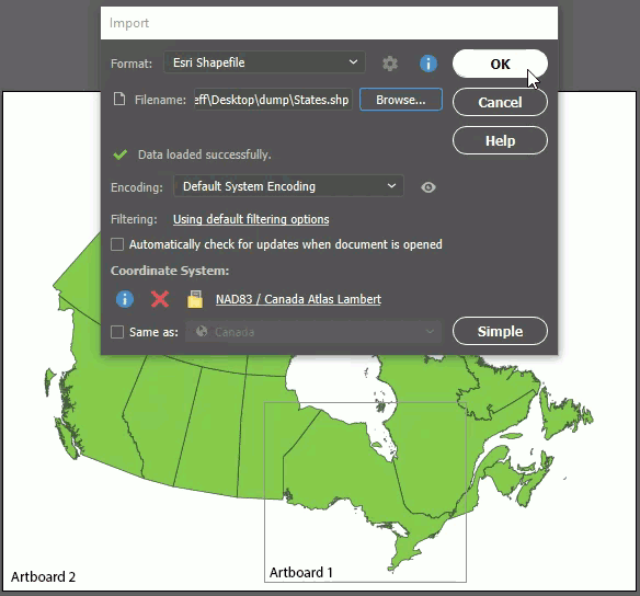
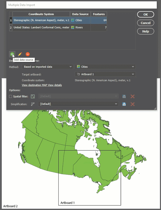
Crop to Artboard
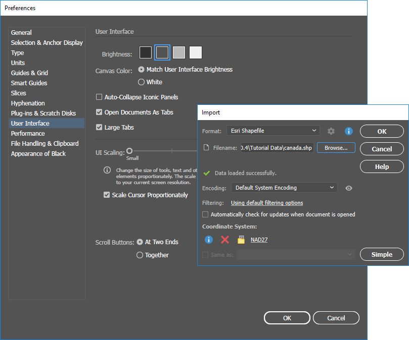
In MAPublisher 10.4, when a matching MAP View is found while using the Import or Copy MAP Objects From tools, you can now choose to crop the added data to an artboard’s extents. This same functionality is available when specifying the destination MAP View in Multiple Data Import. Furthermore, if you don’t want to add data to the existing MAP View, you now have the option to specify which artboard the incoming data will be added to.
New Look
We’ve changed the look of the MAPublisher tools and dialogs to match the colours, fonts, and styles of the Adobe Illustrator interface. So as you use the MAPublisher tools, it feels more like you are still using Illustrator – which of course, you are! The MAPublisher tool and dialog styles will also change to match any changes in the Illustrator interface preferences. Note that the interface changes only apply to Adobe Creative Cloud versions of Illustrator, not CS6.
MAPublisher 10.4 Release Notes
Support for Equal Earth projection
New options available to auto-crop data when importing or copying MAP objects
Enhanced user interface matching Adobe Illustrator interface preferences
We’re excited to announce the release of MAPublisher 10.3 for Adobe Illustrator. We’ve listened to your feedback and worked closely with our users to build features to improve map design and productivity. Stay tuned for more blog posts and other resources that go deeper into some of the new features. For now, here’s an overview:
MAPublisher 10.3
This update contains new features and performance improvements as well as fixes for reported issues. Some highlights are summarized below, for the full release notes see below.
Compatible with Adobe Illustrator CC 2019. We’re committed to providing the best GIS and cartography tools for building great quality maps in Adobe Illustrator. Improvements to our user interface to support high-resolution monitors, and this release is fully compatible with the latest Adobe Illustrator CC 2019 on both Windows (32-bit and 64-bit) and Mac.
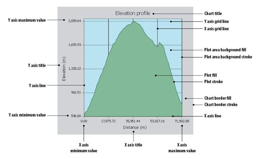
Create Elevation Profile charts. An often-requested feature from our users, elevation data for points along a selected path can now be collected and displayed as an elevation profile in a highly customizable chart. The data is downloaded in real-time from a server (internet connection is required), which can then be customized to your liking using the available settings. Frequently used settings can even be saved for future use.
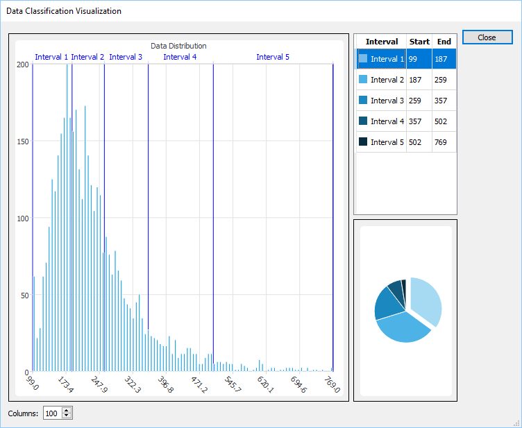
View data distribution when batch generating rules in MAP Themes and MAP LabelPro. When selecting a data classification in MAP Themes or MAP LabelPro, you now have the ability to see how it affects the data distribution in an interactive histogram and chart. Histograms are a great way to visualize continuous data in intervals and useful for large sets of data points.
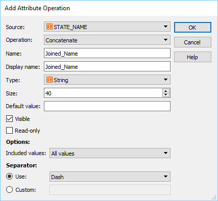
Improved attribute capabilities in ‘Join’ tools. We have added many attribute management improvements to MAPublisher Join tools (Join Areas, Join Points, and Join Lines). You can now better manage how attributes are handled during a Join process, including the ability to calculate new attributes. We also added additional operations to help you better sort and calculate statistics from attributes.
MAPublisher 10.3 Release Notes
Compatible with Adobe Illustrator CC 2019
Create Elevation Profile charts
View data distribution when batch generating rules in MAP Themes and MAP LabelPro
Improved layer, attribute, and feature filtering and simplification capabilities
Toronto, ON, July 10, 2018 – Avenza Systems Inc., producers of the Avenza Maps® app for mobile devices and geospatial plug-ins for Adobe Creative Cloud, including Geographic Imager® for Adobe Photoshop®, is pleased to announce the release of MAPublisher® 10.2 for Adobe Illustrator.
This MAPublisher release improves on streamlining data import, specifically the ability to target specific layers, attributes, and features using filtering options and tools. In addition, requested features such as new format support and GeoJSON export are also included in this release.
“Over the past several quarters, we have reached out to numerous cartographers and GIS professionals to gain insight on map production workflows and best practices,” said Ted Florence, President of Avenza. “We’re learning a lot and excited to continuously work with the mapping community to support their efforts and projects to map this world using the MAPublisher tools they love.”
Enhancements and new features of MAPublisher 10.2
Filter layers and attributes with expressions on import
Simplify complex art on import
Import support for WFS 2.0 and AutoCAD 2018
Export support for GeoJSON and AutoCAD 2018
User interface and usability enhancements
More about MAPublisher for Adobe Illustrator
MAPublisher for Adobe Illustrator is powerful map production software for creating high-quality maps from GIS data. MAPublisher cartographic tools leverage the superior graphic design environment of Adobe Illustrator to manipulate features and produce print-ready, mobile, and online maps with accuracy and efficiency.
MAPublisher 10.2 is available free of charge to all MAPublisher users with currently active maintenance subscription and as an upgrade for non-maintenance users starting at US$599. New commercial licenses are available from US$1399. MAPublisher FME Auto and MAPublisher LabelPro are also available as add-ons starting at US$399 per license. Floating, volume and academic pricing are also available. Prices include one year of full maintenance. Visit www.avenza.com/mapublisher for more details.
More about Avenza Systems Inc.
Avenza Systems Inc. is an award-winning, privately held corporation that provides cartographers and GIS professionals with powerful software tools to make better maps. In addition to desktop software offerings for Mac and Windows users, Avenza offers product training, as well as the Avenza Maps app for selling, purchasing, distributing and using maps on iOS and Android mobile device in an iTune-like environment. Visit www.avenza.com for more details.
For further information contact Avenza Systems | 416-487-5116 | info@avenza.com | www.avenza.com
Automatic MAP Theme legend updates and more new exciting features
Toronto, ON, March 5, 2018 – Avenza Systems Inc., producers of the Avenza Maps® app for mobile devices and geospatial plug-ins for Adobe Creative Cloud, including Geographic Imager® for Adobe Photoshop®, is pleased to announce the release of MAPublisher® 10.1 for Adobe Illustrator.
This MAPublisher release improves on MAP Themes by adding the ability to automatically update existing legends when a theme is modified. In addition, requested features such as a new page indexing feature and GPX export are now supported. “Listening to our users drives how we improve MAPublisher and these time-saving features will help them become more efficient,” said Ted Florence, President of Avenza. “We’re continuously focusing on understanding how our users map the world and it’s an exciting time to be a part of the process.”
Enhancements and new features of MAPublisher 10.1
MAP Theme Legends automatically update existing legends when modified
A new Text Utility tool to create lines from text on a path
A new Make Index feature to include page numbers when creating indexes
Export to GPS Exchange format (GPX) now supported
A new MAP Theme setting to scale charts by radius
A number of additional user interface and usability enhancements.
More about MAPublisher for Adobe Illustrator
MAPublisher for Adobe Illustrator is powerful map production software for creating high-quality maps from GIS data. MAPublisher cartographic tools leverage the superior graphic design environment of Adobe Illustrator to manipulate features and produce print-ready, mobile, and online maps with accuracy and efficiency.
MAPublisher 10.1 is available free of charge to all MAPublisher users with currently active maintenance subscription and as an upgrade for non-maintenance users starting at US$599. New commercial licenses are available from US$1399. MAPublisher FME Auto and MAPublisher LabelPro are also available as add-ons starting at US$399 per license. Floating, volume and academic pricing are also available. Prices include one year of full maintenance. Visit www.avenza.com/mapublisher for more details.
More about Avenza Systems Inc.
Avenza Systems Inc. is an award-winning, privately held corporation that provides cartographers and GIS professionals with powerful software tools to make better maps. In addition to desktop software offerings for Mac and Windows users, Avenza offers product training, as well as the Avenza Maps app for selling, purchasing, distributing and using maps on iOS and Android mobile device in an iTune-like environment. Visit www.avenza.com for more details.
For further information contact:
Avenza Systems | 416-487-5116 | info@avenza.com | www.avenza.com
More than 10,000 maps for public consumers and 26,000 maps for intelligence community
Toronto, ON, January 10, 2018 – Avenza Systems Inc., producers of MAPublisher® cartographic software for Adobe® Illustrator® and Geographic Imager® geospatial tools for Adobe Photoshop®, announces the official release of more than 36,000 maps by LAND INFO Worldwide Mapping, LLC on the Avenza Map Store, exclusively for use in Avenza Maps®, its market-leading, award-winning mobile mapping app.
Avenza Systems and LAND INFO, a leading provider of global digital topographic map data, satellite imagery and value-added remote sensing solutions including advanced Object Based Image Analysis, have partnered to bring more than 10,000 maps to public consumers and 26,000 additional maps exclusively to Avenza Maps for GEOINT users. The GEOINT App Store, developed by the United States National Geospatial-Intelligence Agency (NGA), makes the Avenza Maps app available to Department of Defense (DoD) and Intelligence Community (IC) personnel.
Avenza Systems President, Ted Florence, comments, “With this release of LAND INFO maps for our users, Avenza confirms its position as a global leader in supporting those who use offline maps for everything from outdoor recreation to tactical military operations.” Nick Hubing, President of LAND INFO, adds, “Our map datasets have traditionally only been available to professional GIS users. As the industry-leading app, Avenza Maps was by far the best path to make our content available to both consumers and professional users needing fast and easy access to mapping in mobile devices.”
Public consumers have access to maps from more than 25 countries, some with 50k, 100k, 200k, and 250k map scales. GEOINT users will have access to maps from more than 100 countries, some with map scales as detailed as 10k and 25k, including several city level maps.
LAND INFO maps are each priced at $3.99 USD and are now available on the Avenza Map Store. GEOINT users have unlimited access to the Avenza Maps Store and downloads without any cost to the user. Additional bundled map sets will be available shortly. The partnership with LAND INFO adds another high-level procurement resource to Avenza Maps. Inquire about additional available data for areas of interest not yet covered.
More about Avenza Maps and Avenza Systems Inc.
The Avenza Maps app is an all-inclusive mapping platform for mobile devices. Users can import and use maps offline in addition to getting maps from the Avenza Map Store. Map publishers can become Avenza Map Store vendors and make their maps available for purchase. Businesses and organizations can upgrade to an Avenza Maps Pro subscription which allows for commercial use, includes enhanced tools and features, and enhanced support. For more information, visit www.avenzamaps.com.
Avenza Systems Inc. is an award-winning, privately held corporation that provides cartographers and GIS professionals with powerful software tools to make better maps. In addition to software offerings for Mac and Windows desktop users and iOS and Android mobile users, Avenza offers value-added data sets, product training and consulting services. Visit www.avenza.com for more details.
For further information, contact:
416-487-5116
info@avenza.com
www.avenza.com
Toronto, ON, January 4, 2018 – Avenza Systems Inc., producers of the Avenza Maps® app for mobile devices and geospatial plug-ins for Adobe Creative Cloud, including MAPublisher® for Adobe Illustrator®, is pleased to announce the release of Geographic Imager® 5.3 for Adobe Photoshop®. This latest update includes many new features including full compatibility with the latest Adobe Photoshop Creative Cloud 2018 release.
Geographic Imager 5.3 also introduces Adobe Photoshop resampling methods in several Geographic Imager tools that include a resampling option for improved image results. Input and display precision controls can now be easily customized to reveal much higher precision values.
“Geographic Imager and MAPublisher are now both fully compatible with Adobe CC 2018,” said Ted Florence, President of Avenza. “We love the feedback from our users about the ability to work with both products in an ideal map production environment,” he added.
Enhancements and new features of Geographic Imager 5.3
Fully compatible with Adobe Photoshop CC 2018 on both Windows and Mac
Fully compatible with macOS 10.13
Adobe Photoshop resampling methods now available for tools that include a resampling option
Input and display precision controls are now separately controlled in Preferences
Advanced export options for specifying BigTIFF or DEM TIFF block size
More about Geographic Imager for Adobe Photoshop
Geographic Imager for Adobe Photoshop leverages the superior image editing capabilities of the world’s premier raster-based image editing software and transforms it into a powerful geospatial production tool. Work with satellite imagery, aerial photos, and DEMs in GeoTIFF and other popular GIS image formats using Adobe Photoshop features such as transparencies, filters, and image adjustments while maintaining georeferencing and support for hundreds of coordinate systems and projections.
Geographic Imager 5.3 is immediately available and free of charge to all current Geographic Imager Maintenance Program members and starting at US$319 for non-maintenance upgrades. New fixed licenses start at US$699. Geographic Imager Basic licenses start at US$99. Academic, floating and volume license pricing is also available. Visit www.avenza.com/geographic-imager for more details.
More about Avenza Systems Inc.
Avenza Systems Inc. is an award-winning, privately held corporation that provides cartographers and GIS professionals with powerful software tools to make better maps. In addition to desktop software offerings for Mac and Windows users, Avenza offers product training, as well as the Avenza Maps app for selling, purchasing, distributing and using maps on iOS and Android mobile devices. Visit www.avenza.com for more details.
For further information contact:
416-487-5116
info@avenza.com
www.avenza.com
Avenza partners with the National Geospatial-Intelligence Agency to bring its popular offline map app to the Department of Defence and Intelligence Community
Toronto, ON, December 5, 2017 – Avenza Systems Inc., producers of MAPublisher® cartographic software for Adobe® Illustrator® and Geographic Imager® geospatial tools for Adobe Photoshop®, is proud to announce that it has officially launched Avenza Maps®, its market-leading, award-winning mobile mapping app, on the GEOINT App Store. Created by the United States National Geospatial-Intelligence Agency (NGA), the GEOINT App Store is exclusively for Department of Defense (DoD) and Intelligence Community (IC) personnel.
Avenza Maps, including unlimited access to the Avenza Map Store’s extensive catalogue of digital maps, is available for iOS devices to all DoD and IC personnel by creating a GEOINT account using existing federal credentials, such as Common Access Card (CAC) or Personal Identity Verification (PIV). Once registered, the Avenza Maps app can be downloaded without cost to their mobile device.
“With the launch of Avenza Maps in the GEOINT App Store, we’re proud to be partnering with the NGA to bolster the value of offline maps for critical missions, safety, and locational awareness,” said Ted Florence, president of Avenza. “We’re excited that our app will be officially accessible by the intelligence community and we’re committed to providing them with a mapping technology solution that has so far exceeded the expectations of our users and partners.”
The Avenza Maps app is made available on the GEOINT App Store for iOS devices through the Innovative GEOINT Application Provider Program (IGAPP). Approved DoD and IC personnel can download the app complimentary to their own mobile device, get unlimited free georeferenced and location-aware maps from the Avenza Map Store, and use them completely offline with a variety of tools including Avenza Maps Pro tier features. For more information about how to get the app, visit the GEOINT App Store website at apps.nga.mil.
More about Avenza Maps and Avenza Systems Inc.
The Avenza Maps app is an all-inclusive mapping platform for mobile devices. Users can import and use maps offline in addition to getting maps from the Avenza Map Store. Map publishers can become Avenza Map Store vendors and make their maps available for purchase. Businesses and organizations can upgrade to an Avenza Maps Pro subscription which allows for commercial use, includes enhanced tools and features, and enhanced support. For more information, visit www.avenzamaps.com.
Avenza Systems Inc. is an award-winning, privately held corporation that provides cartographers and GIS professionals with powerful software tools to make better maps. In addition to software offerings for Mac and Windows desktop users and iOS and Android mobile users, Avenza offers value-added data sets, product training and consulting services. Visit www.avenza.com for more details.
For further information contact:
Avenza Systems
416-487-5116
info@avenza.com
www.avenza.com
Adobe CC 2018 compatibility and data link management
Toronto, ON, November 14, 2017 – Avenza Systems Inc., producers of the Avenza Maps® app for mobile devices and geospatial plug-ins for Adobe Creative Cloud, including Geographic Imager® for Adobe Photoshop®, is pleased to announce the release of MAPublisher® 10 for Adobe Illustrator. This latest update includes many new features and enhancements including full compatibility with Adobe Illustrator Creative Cloud 2018.
This MAPublisher release introduces the ability to manage data links where MAP layers in a document can be updated when its source data has been modified. “We’ve reached out for valuable user feedback since our last release and have heard many requests for improved GIS data management and streamlined import,” said Ted Florence, President of Avenza. “By developing and implementing features from this feedback, we’re committed to maintaining MAPublisher as the industry-standard cartography tool to help map makers create amazing products for print, mobile, and web.”
Enhancements and new features of MAPublisher 10
Fully compatible with the latest Adobe Illustrator CC 2018 on both Windows (32-bit and 64-bit) and Mac
New ability to create and manage data links for MAPublisher documents. MAP layers in a document can be updated when its source data has been modified.
New attribute filter capability to select which layers and attributes to include or exclude prior to import
New geometry filter capability to select which features to include or exclude prior to import
New scale bar styles and customization options including ability to save, import, and export scale bar styles
New Visvalingam-Whyatt simplification method and fault tolerance settings to simplify art
New MAP Tagger Tool ability to create custom leader lines with various arrow styles and an option to snap leader line to different positions around a label
A new Point Utilities action that can rotate points to the angle of latitude
A modified Text Utilities action that can draw a point for text based upon text alignment for indexing purposes
New settings for North Arrow location including True North and a custom coordinate and options to use Great Circle or compass method.
New MAP Web Author HTML5 export customization options including adjustable scale bar.
A number of user interface and usability enhancements.
More about MAPublisher for Adobe Illustrator
MAPublisher for Adobe Illustrator is powerful map production software for creating high-quality maps from GIS data. MAPublisher cartographic tools leverage the superior graphic design environment of Adobe Illustrator to manipulate features and produce print-ready, mobile, and online maps with accuracy and efficiency.
MAPublisher 10 is available free of charge to all MAPublisher users with an active maintenance subscription and as an upgrade for non-maintenance users starting at US$599. New commercial licenses are available from US$1399. MAPublisher FME Auto and MAPublisher LabelPro are also available as add-ons starting at US$399 per license. Floating and volume pricing are also available. Prices include one year of full maintenance. Visit www.avenza.com/mapublisher for more details.
More about Avenza Systems Inc.
Avenza Systems Inc. is an award-winning, privately held corporation that provides cartographers and GIS professionals with powerful software tools to make better maps. In addition to desktop software offerings for Mac and Windows users, Avenza offers product training, as well as the Avenza Maps app for purchasing and using maps on iOS and Android mobile devices. Visit www.avenza.com for more details.
For further information contact:
Avenza Systems
416-487-5116
info@avenza.com
www.avenza.com
Latest European Union maps highlight recent political changes
Toronto, ON, March 9, 2017 – Avenza Systems Inc., producers of MAPublisher® cartographic software for Adobe® Illustrator® and Geographic Imager® geospatial tools for Adobe Photoshop®, is delighted to announce that updated political maps of the European Union (EU) are now available on the Avenza Map Store. After a sensational launch in Europe of the printed versions, map publisher XYZ Maps, is making the digital maps available through Avenza’s market-leading, award-winning mobile mapping app, Avenza Maps. Recently featured in the Scottish newspaper, The National, the standard EU 2019 – Post Brexit map shows the UK out of the EU. However, the map attracting widespread attention is the alternative Scottish EU 2019 – Post Brexit map as it shows an independent Scotland still a member of the EU, while the reduced UK of England, Wales and Northern Ireland are out.
“We continuously support all of our map publishers who strive to improve maps for everyone,” said Ted Florence, President of Avenza Systems Inc. “The ease and speed of which maps can be published to a world-wide audience using the Avenza Maps platform is unparalleled,” he added. “Historic events that change the political horizon are documented not only by the media and social networks, but also in maps because it can affect the way we travel and move.”
The Avenza Maps app is an all-inclusive mapping platform for iOS, Android, and Windows mobile devices. Consumers can download the app for free, get georeferenced maps from the Avenza Map Store, and use them completely offline with a variety of tools. Map publishers can register as a vendor in the Avenza Map Store and generate revenue by pricing their maps and making them available for purchase in this iTunes-like model for maps. Businesses and organizations can upgrade to a cost-effective Avenza Maps Pro subscription which allows for commercial use, includes enhanced tools and features, and enhanced support. For more information, visit the Avenza Maps website at www.avenzamaps.com.
More about Avenza Systems Inc.
Avenza Systems Inc. is an award-winning, privately held corporation that provides cartographers and GIS professionals with powerful software tools to make better maps. In addition to software offerings for Mac and Windows users, Avenza offers value-added data sets, product training and consulting services, as well as the Avenza Maps app for purchasing and using maps on iOS, Android, and Windows devices. Visit www.avenza.com for more details.
For further information contact:
416-487-5116
info@avenza.com
www.avenza.com