Toronto, ON, May 15, 2024 – Avenza Systems Inc., producers of the Avenza Maps® app for mobile devices and geospatial extensions for Adobe Creative Cloud®, including MAPublisher® for Adobe Illustrator®, is pleased to announce the release of Geographic Imager® version 6.8 for Adobe Photoshop®. This version introduces the new Export Contours tool, official compatibility with macOS Sonoma (version 14), and also includes several performance enhancements and bug fixes.
Geographic Imager for Adobe Photoshop delivers an all-encompassing solution to import, edit, and export geospatial images such as aerial and satellite imagery. Work with digital elevation models, GeoTIFFs, and other popular GIS image formats, using Adobe Photoshop features such as transparencies, filters, cropping, and image adjustments, while maintaining georeferencing and support for hundreds of coordinate systems and projections.
New features for Geographic Imager v6.8 for Adobe Photoshop include:
Export Contours tool: The new Export Contours tool allows users to input raster elevation data to output vector contour lines that can be exported for use in MAPublisher.
macOS Sonoma compatibility: Geographic Imager officially supports the new macOS Sonoma (version 14) update.
Additional performance enhancements and bug fixes
Users require a valid Adobe Creative Cloud subscription and a compatible operating system to utilize the improvements and enhancements offered in Geographic Imager v6.8. For questions and information on how compatibility requirements may affect your organization, please contact our Support Centre.
Geographic Imager v6.8 is available immediately and free of charge to all current Geographic Imager Maintenance Program members and starts at US$399 for non-maintenance upgrades. New fixed licenses start at US$859. Geographic Imager Basic Edition licenses start at US$129. Academic, floating, and volume license pricing is also available. Visit www.avenza.com/geographic-imager for more information.
More about Avenza Systems Inc.
Avenza Systems Inc. is an award-winning, privately held corporation that provides cartographers and GIS professionals with powerful software tools to make better maps. Avenza also offers the mobile Avenza Maps app to sell, purchase, distribute, and use maps on iOS and Android devices. For further information contact: +1 416-487-5116 – info@avenza.com – www.avenza.com
Toronto, ON, October 31, 2023 – Avenza Systems Inc., producers of the Avenza Maps® app for mobile devices and geospatial extensions for Adobe Creative Cloud®, including Geographic Imager® for Adobe Photoshop®, is pleased to announce the release of MAPublisher® version 11.3 for Adobe Illustrator®. This version offers full compatibility with Adobe Illustrator 2024 (version 28), macOS Sonoma (version 14), and the FME Auto 2023 update. It also includes performance enhancements and bug fixes.
MAPublisher cartography software seamlessly integrates more than seventy GIS mapping tools into Adobe Illustrator to help you create beautiful maps from geospatial data. Import industry-standard GIS data formats and make crisp, clean maps with all attributes and georeferencing intact using the Adobe Illustrator design environment.
New features of MAPublisher v11.3 for Adobe Illustrator include:
Adobe Creative Cloud 2024 compatibility: MAPublisher now supports Adobe Illustrator 2024 (version 28.0) on both Mac and Windows
macOS Sonoma compatibility: MAPublisher also officially supports the new macOS Sonoma (version 14) update
FME Auto 2023 compatibility: MAPublisher now supports the recent FME 2023.1 updates when using the FME Auto
Additional performance improvements and bug fixes
Users require a valid Adobe Creative Cloud subscription and a compatible operating system to utilize the improvements and enhancements offered in MAPublisher v11.3. For questions and information on how compatibility requirements may affect your organization, please contact our Support Centre.
MAPublisher 11.3 is immediately available free of charge to all current MAPublisher users with active maintenance and as an upgrade for non-maintenance users starting at US$699. New licenses are available from US$1619. MAPublisher FME Auto and MAPublisher LabelPro are also available as add-ons starting at US$539. Academic, floating, and volume licenses are also available. Prices include one year of full maintenance. Visit www.avenza.com/mapublisher for more details.
More about Avenza Systems Inc.
Avenza Systems Inc. is an award-winning, privately held corporation that provides cartographers and GIS professionals with powerful software tools to make better maps. Avenza also offers the mobile Avenza Maps app to sell, purchase, distribute, and use maps on iOS and Android devices. For further information contact: 416-487-5116 – info@avenza.com – www.avenza.com
Toronto, ON, September 27, 2023 – Avenza Systems Inc., producers of the Avenza Maps® app for mobile devices and geospatial extensions for Adobe Creative Cloud®, including MAPublisher® for Adobe Illustrator®, is pleased to announce the release of Geographic Imager® version 6.7 for Adobe Photoshop®. This version offers full compatibility with Adobe Photoshop 2024 (version 25), and also includes some performance improvements and bug fixes.
Geographic Imager for Adobe Photoshop delivers an all-encompassing solution to import, edit, and export geospatial images such as aerial and satellite imagery. Work with digital elevation models, GeoTIFFs, and other popular GIS image formats, using Adobe Photoshop features such as transparencies, filters, cropping, and image adjustments, while maintaining georeferencing and support for hundreds of coordinate systems and projections.
Users require a valid Adobe Creative Cloud subscription and a compatible operating system to utilize the improvements and enhancements offered in Geographic Imager v6.7. For questions and information on how compatibility requirements may affect your organization, please contact our Support Centre.
Geographic Imager v6.7 is immediately available and is free of charge to all current Geographic Imager Maintenance Program members and starts at US$379 for non-maintenance upgrades. New fixed licenses start at US$809. Geographic Imager Basic Edition licenses start at US$119. Academic, floating, and volume license pricing is also available. Visit www.avenza.com/geographic-imager for more information.
More about Avenza Systems Inc.
Avenza Systems Inc. is an award-winning, privately held corporation that provides cartographers and GIS professionals with powerful software tools to make better maps. Avenza also offers the mobile Avenza Maps app to sell, purchase, distribute, and use maps on iOS and Android devices. For further information contact: +1 416-487-5116 – info@avenza.com – www.avenza.com
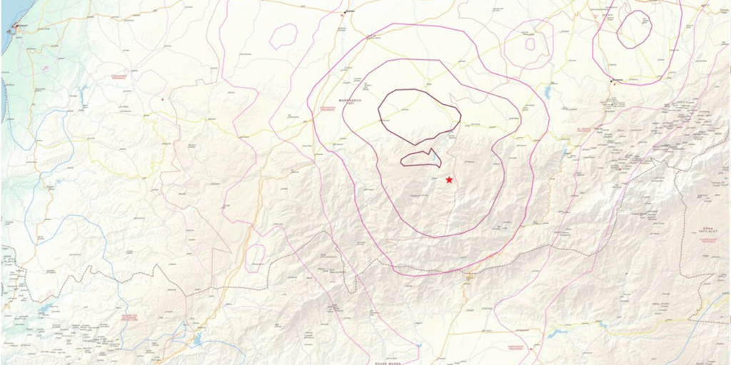
An earthquake registered in Morocco approximately 72 kilometres (44.7 miles) southwest of Marrakech on Friday September 8, 2023, devastating the country and being felt far and wide. The quake had a magnitude of 6.8 and state media reported Monday that at least 2,862 people have been killed and 2,562 have been injured from its effects.
Avenza Map Store and Search and Rescue Maps
Immediately, Search and Rescue teams mounted efforts to help those trapped or injured and developed a series of maps to aid in those efforts. The Avenza Maps team worked with Reliefweb and uploaded the maps to the Avenza Map Store for worldwide and free distribution and use on mobile devices using the Avenza Maps app. Reliefweb works to keep humanitarian efforts informed, and combining their maps with Avenza Maps app software allows Search and Rescue teams to know their location and collect data offline without cell reception or wifi.
Avenza Systems Inc. is an award-winning, privately held corporation that provides cartographers and GIS professionals with powerful software tools to make better maps. Avenza also offers the mobile Avenza Maps app to sell, purchase, distribute, and use maps on iOS and Android devices. For further information contact: 416-487-5116 – info@avenza.com – www.avenza.com
Toronto, ON, July 31, 2023 – Avenza Systems Inc., producers of the Avenza Maps® app for mobile devices and geospatial extensions for Adobe Creative Cloud®, including Geographic Imager® for Adobe Photoshop®, is pleased to announce the release of MAPublisher® version 11.2 for Adobe Illustrator®. This version comes with the brand-new Vector Basemaps tool and includes additional performance enhancements and bug fixes.
MAPublisher cartography software seamlessly integrates more than seventy GIS mapping tools into Adobe Illustrator to help you create beautiful maps from geospatial data. Import industry-standard GIS data formats and make crisp, clean maps with all attributes and georeferencing intact using the Adobe Illustrator design environment.
New features of MAPublisher v11.2 for Adobe Illustrator include:
The new Vector Basemaps tool: The new MAPublisher Vector Basemaps tool imports georeferenced vector data from an online server. Imported data is autostyled based on the zoom level and attribute information, but can also be configured or imported by users to create savable custom styles.
Additional performance improvements and bug fixes
Users require a valid Adobe Creative Cloud subscription and a compatible operating system to utilize the improvements and enhancements offered in MAPublisher v11.2. For questions and information on how compatibility requirements may affect your organization, please contact our Support Centre.
MAPublisher 11.2 is immediately available free of charge to all current MAPublisher users with active maintenance and as an upgrade for non-maintenance users starting at US$699. New licenses are available from US$1619. MAPublisher FME Auto and MAPublisher LabelPro are also available as add-ons starting at US$539. Academic, floating, and volume licenses are also available. Prices include one year of full maintenance. Visit www.avenza.com/mapublisher for more details.
More about Avenza Systems Inc.
Avenza Systems Inc. is an award-winning, privately held corporation that provides cartographers and GIS professionals with powerful software tools to make better maps. Avenza also offers the mobile Avenza Maps app to sell, purchase, distribute, and use maps on iOS and Android devices.
Toronto, ON, December 12, 2022 – Avenza Systems Inc., producers of the Avenza Maps® app for mobile devices and geospatial extensions for Adobe Creative Cloud®, including MAPublisher® for Adobe Illustrator®, is pleased to announce the release of Geographic Imager® version 6.6 for Adobe Photoshop®.
This version comes with official support for all Apple Silicon processors as well as full compatibility with Adobe Photoshop 2023 (version 24) and macOS Ventura (version 13). Geographic Imager v6.6 also introduces a brand-new welcome screen design with increased discoverability for users and includes additional performance enhancements and bug fixes.
Geographic Imager for Adobe Photoshop delivers an all-encompassing solution to import, edit, and export geospatial images such as aerial and satellite imagery. Work with digital elevation models, GeoTIFFs, and other popular GIS image formats, using Adobe Photoshop features such as transparencies, filters, cropping, and image adjustments, while maintaining georeferencing and support for hundreds of coordinate systems and projections.
New features of Geographic Imager v6.6 for Adobe Photoshop include:
Apple Silicon processor support: Geographic Imager is now officially compatible with all Apple Silicon processors
Adobe Creative Cloud 2023 compatibility: Geographic Imager now supports Adobe Photoshop 2023 (version 24.0) on both Mac and Windows
macOS Ventura compatibility: Geographic Imager also officially supports the new macOS Ventura (version 13) update
New welcome screen design: Improved discoverability for users with more content to aid in getting started or inspired with Geographic Imager
Additional performance enhancements and bug fixes
Users require a valid Adobe Creative Cloud subscription and a compatible operating system to utilize the improvements and enhancements offered in Geographic Imager v6.6. For questions and information on how compatibility requirements may affect your organization, please contact our Support Centre.
Geographic Imager v6.6 is immediately available and is free of charge to all current Geographic Imager Maintenance Program members and starts at US$349 for non-maintenance upgrades. New fixed licenses start at US$749. Geographic Imager Basic Edition licenses start at US$99. Academic, floating, and volume license pricing is also available. Visit www.avenza.com/geographic-imager for more information.
More about Avenza Systems Inc.
Avenza Systems Inc. is an award-winning, privately held corporation that provides cartographers and GIS professionals with powerful software tools to make better maps. Avenza also offers the mobile Avenza Maps app to sell, purchase, distribute, and use maps on iOS and Android devices. For further information contact: +1 416-487-5116 – info@avenza.com – www.avenza.com
Toronto, ON, November 1, 2022 – Avenza Systems Inc., producers of the Avenza Maps® app for mobile devices and geospatial extensions for Adobe Creative Cloud®, including Geographic Imager® for Adobe Photoshop®, is pleased to announce the release of MAPublisher® 11.1 for Adobe Illustrator®. This version offers full compatibility with Adobe Illustrator 2023 (Version 27.0) as well as with the brand new macOS Ventura (version 13) update. It also includes maintenance and bug fixes.
MAPublisher cartography software seamlessly integrates more than seventy GIS mapping tools into Adobe Illustrator to help you create beautiful maps from geospatial data. Import industry-standard GIS data formats and make crisp, clean maps with all attributes and georeferencing intact using the Adobe Illustrator design environment.
Users require a valid Adobe Creative Cloud subscription and a compatible operating system to utilize the improvements and enhancements offered in MAPublisher 11.1. For questions and information on how compatibility requirements may affect your organization, please contact our Support Centre.
MAPublisher 11 is immediately available free of charge to all current MAPublisher users with active maintenance and as an upgrade for non-maintenance users starting at US$649. New licenses are available from US$1499. MAPublisher FME-Auto and MAPublisher LabelPro are also available as add-ons starting at US$499. Academic, floating, and volume licenses are also available. Prices include one year of full maintenance. Visit www.avenza.com/mapublisher for more details.
More about Avenza Systems Inc.
Avenza Systems Inc. is an award-winning, privately held corporation that provides cartographers and GIS professionals with powerful software tools to make better maps. Avenza also offers the mobile Avenza Maps app to sell, purchase, distribute, and use maps on iOS and Android devices. For further information contact: +1 416-487-5116 – info@avenza.com – www.avenza.com
Toronto, CA (October 18, 2022) – Avenza Systems Inc., producer of the Avenza Maps® app for mobile devices is pleased to announce the upcoming releases of MAPublisher® 11.1 for Adobe Illustrator® 2023 and Geographic Imager® 6.6 for Adobe Photoshop® 2023. These updates will provide a range of user interface improvements, feature enhancements, bug fixes, and performance upgrades, along with compatibility with the latest Adobe Creative Cloud applications.
Data-driven Map Design in Illustrator with MAPublisher
MAPublisher cartography software seamlessly integrates more than seventy GIS mapping tools into Adobe Illustrator to help you create beautiful maps from GIS data. Import industry-standard GIS data formats and make crisp, clean maps with all attributes and georeferencing intact using the Adobe Illustrator design environment.
Expected improvements for the MAPublisher 11.1 extension for Adobe Illustrator include maintenance fixes and Adobe Illustrator 2023 compatibility. Additional feature upgrades to be announced soon.
Powerful Imagery Editing in Photoshop with Geographic Imager
Geographic Imager for Adobe Photoshop delivers an all-encompassing solution to import, edit, and export geospatial images such as aerial and satellite imagery. Work with digital elevation models, GeoTIFFs, and other popular GIS image formats while using Adobe Photoshop features such as transparencies, filters, cropping, and image adjustments; all while maintaining georeferencing and support for hundreds of coordinate systems and projections
Expected improvements of the Geographic Imager 6.6 extension for Adobe Photoshop include official Apple Silicon support, a revamped discoverability screen, maintenance fixes, and Adobe Photoshop 2023 compatibility.
Upgrade or Purchase
MAPublisher 11.1 will be available free of charge to all current MAPublisher users with active maintenance and as an upgrade for non-maintenance users starting at US$649. New licenses are available from US$1499. MAPublisher FME Auto and MAPublisher LabelPro are also available as add-ons starting at US$499.
Geographic Imager 6.6 will be available and free of charge to all current Geographic Imager Maintenance Program members and starts at US$349 for non-maintenance upgrades. New fixed licenses start at US$749. Geographic Imager Basic Edition licenses start at US$99.
Academic, floating, and volume license pricing is also available for both extension suites.
More about Avenza Systems Inc.
Avenza Systems Inc. is an award-winning, privately held corporation that provides cartographers and GIS professionals with powerful software tools to make better maps. Avenza also offers the mobile Avenza Maps app to sell, purchase, distribute, and use maps on iOS and Android devices. For more information, visit www.avenza.com.
For further information contact: 416-487-5116 – info@avenza.com – www.avenza.com
Avenza Systems Partners with Leading Defense Contractor SAIC to Offer a Verified Secure Version of its Popular Offline Map App
Toronto, ON, Canada (December 20, 2021) – Avenza Systems Inc., producers of MAPublisher® cartographic software for Adobe® Illustrator® and Geographic Imager® geospatial tools for Adobe Photoshop®, is proud to announce that it has partnered with SAIC and launched Avenza Maps®: RA Edition as a cornerstone of SAIC’s new Rugged Apps™ platform.
“SAIC is very pleased to provide Avenza Maps through our Rugged Apps™ platform. Avenza’s app delivers enhanced mission value in a verified and secure manner, allowing use with confidence by users,” said Michael LaRouche, President of SAIC’s National Security and Space Sector.
SAIC’s new Rugged Apps™ platform provides government customers with highly-secured versions of their preferred mobile applications used to complete missions every day. Avenza Maps: RA Edition passes National Information Assurance Partnership (NIAP) compliant processes to ensure the app is safe and secure for government use in a wide range of applications including land management, forestry, military, and disaster response as well as sensitive commercial environments such as oil and gas, mining, forestry and healthcare.
“We recognize the utmost importance of increased and reliable cyber-security, especially when it comes to mobile computing, and we are delighted to work with SAIC to make Avenza Maps Pro available through the Rugged Apps platform. Rugged Apps is a much-needed way of ensuring that one’s mobile apps are safe and we encourage all government and private sector users seeking to protect their systems to obtain their apps via Rugged Apps,” said Ted Florence, President of Avenza.
In addition to being NIAP compliant, Avenza Maps: RA Edition also offers all the features of Avenza Maps Pro as well as unlimited access to all Avenza Map Store content, including paid maps, at no additional cost.
Avenza Maps: RA Edition is currently available for iOS devices. Availability on Android devices will be launched in the near future. Government customers are able to order through NASA SEWP (Solutions for Enterprise-Wide Procurement) or by contacting Avenza Sales directly by phone at 800-884-2555 (North America) or at 1-416-487-5116 or by email at sales@avenza.com. For more information, visit the Avenza Maps: RA Edition website at www.avenzamaps.com/ruggedapps or the SAIC Rugged Appswebsite at www.saic.com/rugged-apps.
About Avenza Maps Avenza Maps is an award-winning offline mapping app used by professionals on a daily basis for search and rescue, to support humanitarian efforts, to fight wildfires and industries operating in remote areas or where offline maps are a necessity. Avenza Maps is also used as a teaching tool in post-secondary education, and by a growing number of recreational users to navigate, and explore off the grid. The app is a one-stop map shop with nearly one million unique map titles available on-demand, no matter where you are in the world, through the Avenza Map Store. Map publishers can register as a vendor in the Avenza Map Store and generate revenue by pricing their maps and making them available for purchase. For more information, visit the Avenza Maps website at www.avenzamaps.com.
More about Avenza Systems Inc. Avenza Systems Inc. is an award-winning, privately held corporation that provides cartographers and GIS professionals with powerful software tools to make better maps. For more information, visit www.avenza.com.
Toronto, ON, August 31, 2022 – Avenza Systems Inc., producers of the Avenza Maps® app for mobile devices and geospatial extensions for Adobe Creative Cloud®, including Geographic Imager® for Adobe Photoshop®, is pleased to announce the release of MAPublisher® 11.0 for Adobe Illustrator®. This version offers full compatibility with the Apple Silicon processor, enhancements to the MAP Attributes panel, a revamped welcome screen, the ability to import OpenStreetMap file formats, a brand new set of MAP Erase tools, and several performance improvements and bug fixes.
MAPublisher cartography software seamlessly integrates more than seventy GIS mapping tools into Adobe Illustrator to help you create beautiful maps from geospatial data. Import industry-standard GIS data formats and make crisp, clean maps with all attributes and georeferencing intact using the Adobe Illustrator design environment.
New major features of the MAPublisher 11.0 extension for Adobe Illustrator include:
Apple Silicon Processor compatibility
MAP Attributes Panel enhancements: Users no longer need to select all attributes for them to appear by default in the features list, with show all/show only selected features toggle buttons
Welcome Screen revamp: Improved discoverability for users with more content to aid in getting started or inspired with MAPublisher
OpenStreetMap file format support: Import OpenStreetMap OSM and PBF file formats
MAP Erase tools: Quickly remove sensitive or unwanted data from maps with the MAP Vector Erase or MAP Erase by Shape tools
Users require a valid Adobe Creative Cloud subscription and a compatible operating system to utilize the improvements and enhancements offered in MAPublisher 11.0. For questions and information on how compatibility requirements may affect your organization, please contact our Support Centre.
MAPublisher 11.0 is immediately available free of charge to all current MAPublisher users with active maintenance and as an upgrade for non-maintenance users starting at US$649. New licenses are available from US$1499. MAPublisher FME-Auto and MAPublisher LabelPro are also available as add-ons starting at US$499. Academic, floating, and volume licenses are also available. Prices include one year of full maintenance. Read more about MAPublisher 11.0 in the release blog, or visit www.avenza.com/mapublisher for more details.
More about Avenza Systems Inc.
Avenza Systems Inc. is an award-winning, privately held corporation that provides cartographers and GIS professionals with powerful software tools to make better maps. Avenza also offers the mobile Avenza Maps app to sell, purchase, distribute, and use maps on iOS and Android devices. For further information contact: 416-487-5116 – info@avenza.com – www.avenza.com