My Account     Contact Us     Cart

What’s New in Geographic Imager 6.5

We are very excited to announce the release of Geographic Imager 6.5, our latest version of the Geographic Imager extension for Adobe Photoshop. 

With Geographic Imager 6.5, we are bringing forward full compatibility with Adobe Photoshop 2022 (23.0.x), Windows 11 and macOS12, support for vector GeoPackages, improvements to the Terrain Shader tool, and several bug fixes.

Here’s what you can expect with the latest Geographic Imager 6.5 release:

Compatibility with Adobe Photoshop 2022 (23.0.x), Windows 11, and macOS 12

We want Geographic Imager users to experience truly seamless integration with the Adobe Photoshop workspace. We are pleased to announce that Geographic Imager 6.5 is now fully compatible with Adobe Photoshop 2022 (23.0.x).

Geographic Imager 6.5 is also fully compatible with the newly released Windows 11, as well as macOS 12 Monterey.

Terrain Shader Improvements

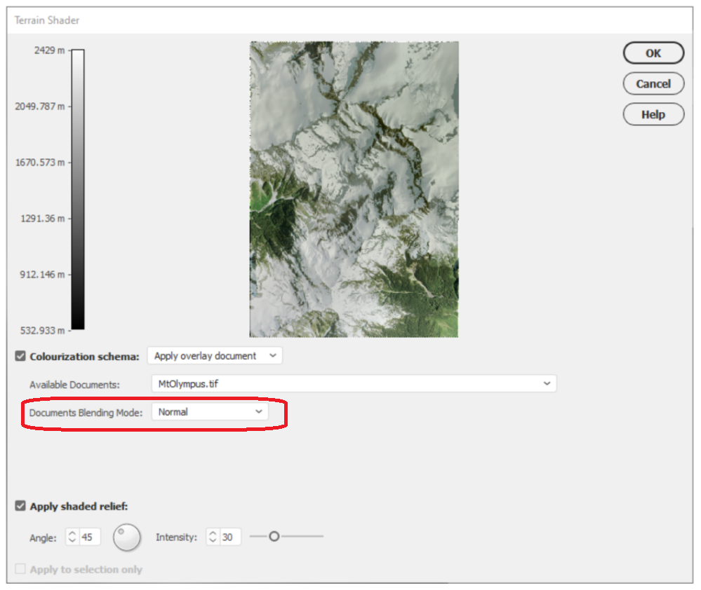
The Terrain Shader tool allows users to create dramatic shaded relief visualizations with elevation data. Combining hillshaded elevation datasets with imagery overlays can create striking topographic representations. With this latest release of Geographic Imager, we are improving the Terrain shader tool to include a document blending mode option. When the “Apply Overlay Image” option is now selected as a colourization schema, users can select from a range of native Photoshop blending modes that improve how imagery layers are overlayed with elevation data.

Import and Export Vector GeoPackages

Several users have requested the ability to import and export vector GeoPackage data. We are happy to announce the full support of vector GeoPackages is now offered with Geographic Imager 6.5. Vector GeoPackages are based on SQLite databases and offer an open-source, compact, lightweight, and flexible data format for easy and efficient storage or geoprocessing of spatial data.

Geographic Imager 6.5 is immediately available today, free of charge to all current Geographic Imager users with active maintenance subscriptions and as an upgrade for non-maintenance users.

What’s New in MAPublisher 10.9 for Adobe Illustrator?

What's New in MAPublisher 10.9 Header

We are very excited to announce the release of MAPublisher 10.9, our latest version of the MAPublisher extension for Adobe Illustrator. 

With MAPublisher 10.9, we are bringing forward full compatibility with Adobe Illustrator 2022, Windows 11, macOS 12, support for Vector GeoPackages and TopoJSON data formats, improvements to the Buffer Art tool, and several bug fixes.

Here’s what you can expect with the latest MAPublisher 10.9 release:

Compatibility with Adobe Illustrator 2022, Windows 11, and macOS 12

We want to ensure our users enjoy a truly seamless experience with the Adobe Illustrator workspace. Our team has worked to ensure that MAPublisher 10.9 is fully compatible with Adobe Illustrator 2022 that was announced at Adobe Max last week. 

MAPublisher 10.9 is also fully compatible with the newly released Windows 11, as well as macOS 12 Monterey.

Import TopoJSON data

New to MAPublisher 10.9 is the ability to import TopoJSON type data formats directly into Adobe Illustrator. A TopoJSON is built off the GeoJSON data format in a way that encodes topology. Geometries in TopoJSON files are collected together from shared line segments called arcs. In this way, TopoJSON data formats can reduce redundancies and improve storage efficiency for spatial data.

What's New in MAPublisher: Import TopoJSON data

Import and Export Vector GeoPackages

Many of our users have requested the ability to import and export vector GeoPackage data. We are happy to announce the full support of vector GeoPackages is now offered with MAPublisher 10.9. Vector GeoPackages are based on SQLite databases and offer an open-source, compact, lightweight, and flexible data format for easy and efficient storage or geoprocessing of spatial data.

Geodesic Options for the Buffer Art Tool

Geodesic options are now available for the Buffer Art tool. This functionality will provide more accurate distance buffers for point data when working on features distant from lines of true scale. Find this option in the “method” section of the Buffer Art tool.

What's New in MAPublisher: MAPublisher Buffer Tool

Default Data filters and Styles on import

MAPublisher 10.9 users can create unique data filters and style settings that can be automatically applied to newly imported data in MAPublisher.

Changes to Compatibility

Avenza announces that compatibility support is changing for its desktop mapping software. Starting with MAPublisher 10.9, both Windows 7 and Adobe CS6 will no longer be supported. Users will require a valid Adobe Creative Cloud subscription and a compatible operating system to utilize the improvements and enhancements offered in MAPublisher 10.9. For questions and more information on how these changes around compatibility may affect your organization, please contact our Support Centre.

MAPublisher 10.9 is immediately available today, free of charge to all current MAPublisher users with active maintenance subscriptions and as an upgrade for non-maintenance users. 

Enter the Avenza Map Competition!

The Avenza Map Competition is live! Enter our map competition for a chance to showcase your favourite maps with the Avenza community and win prizes! The competition consists of two categories: “Open” and “Student”, with two sets of exciting prizes. Submit your Map today!

Avenza Map Competition

Avenza Releases Geographic Imager 6.5 for Adobe Photoshop

Toronto, ON, December 14, 2021 – Avenza Systems Inc., producers of the Avenza Maps® app for mobile devices and geospatial extensions for Adobe® Creative Cloud®, including MAPublisher® for Adobe Illustrator®, is pleased to announce the release of Geographic Imager® 6.5 for Adobe Photoshop®. This latest release offers full compatibility with the latest release of Adobe Photoshop 2022 (23.0.x), compatibility with Windows 11 and macOS 12, import and export support for vector GeoPackages, and enhancements to the Terrain Shader tool including a new “Document Blending Mode” for overlaying images on elevation data.

Powering the Geospatial Image Editing Process

Geographic Imager for Adobe Photoshop delivers an all-encompassing solution to import, edit, and export geospatial images such as aerial and satellite imagery. Work with digital elevation models, GeoTIFFs, and other popular GIS image formats, now including GeoPackages, while using Adobe Photoshop features such as transparencies, filters, cropping, and image adjustments; all while maintaining georeferencing and support for hundreds of coordinate systems and projections.

New features of the Geographic Imager 6.5 plugin for Adobe Photoshop include:

  • Photoshop Compatibility: Works with the newest Adobe Photoshop 2022 (23.0.x)
  • Compatibility with Windows 11 and macOS 12
  • GeoPackage Support: Import and export vector GeoPackages
  • Terrain Shader Enhancements: “Document blending mode” options for image overlays with Terrain Shader
  • Additional feature enhancements and bug fixes

Geographic Imager 6.5 is immediately available and free of charge to all current Geographic Imager Maintenance Program members and starts at US$349 for non-maintenance upgrades. New fixed licenses start at US$749. Geographic Imager Basic Edition licenses start at US$99. Academic, floating, and volume license pricing is also available. For more information, visit www.avenza.com/geographic-imager.

More about Avenza Systems Inc.

Avenza Systems Inc. is an award-winning, privately held corporation that provides cartographers and GIS professionals with powerful software tools to make better maps. In addition to desktop mapping software, Avenza offers the mobile Avenza Maps app to sell, purchase, distribute, and use maps on iOS and Android devices. For more information, visit www.avenza.com.

For further information contact: + 1 416-487-5116 – info@avenza.comwww.avenza.com

Avenza Releases MAPublisher 10.9 for Adobe Illustrator

Toronto, ON, November 9, 2021 – Avenza Systems Inc., producers of the Avenza Maps® app for mobile devices and geospatial extensions for Adobe Creative Cloud®, including Geographic Imager® for Adobe Photoshop®, is pleased to announce the release of MAPublisher® 10.9 for Adobe Illustrator®. This version offers compatibility with Adobe Illustrator 2022, Windows 11, and macOS 12. It also provides a variety of feature updates including the widely requested support for the vector GeoPackage and TopoJSON data formats, new Geodesic options for the Buffer Art tool, default filter on import and style on import options, and several performance improvements and bug fixes.

MAPublisher cartography software seamlessly integrates more than seventy GIS mapping tools into Adobe Illustrator to help you create beautiful maps from geospatial data. Import industry-standard GIS data formats and make crisp, clean maps with all attributes and georeferencing intact using the Adobe Illustrator design environment.

New major features of the MAPublisher 10.9 extension for Adobe Illustrator include:

  • Adobe Illustrator 2022 compatibility
  • Windows 11 and macOS 12 Monterey compatibility
  • TopoJSON support: Import TopoJSON data
  • GeoPackage support: Import and export vector GeoPackage data 
  • Geodesic Buffer settings: Provides more accurate distance buffers on point data when working on features distant from lines of true scale
  • Default import filters and styles: Specify default options for filtering and displaying data that is imported into MAPublisher

Avenza announces that compatibility support is changing for its desktop mapping software. Starting with MAPublisher 10.9, both Windows 7 and Adobe CS6 will no longer be supported. Users will require a valid Adobe Creative Cloud subscription and a compatible operating system to utilize the improvements and enhancements offered in MAPublisher 10.9. For questions and more information on how these changes around compatibility may affect your organization, please contact our Support Centre.

MAPublisher 10.9 is immediately available free of charge to all current MAPublisher users with active maintenance and as an upgrade for non-maintenance users starting at US$649. New licenses are available from US$1499. MAPublisher FME-Auto and MAPublisher LabelPro are also available as add-ons starting at US$499. Academic, floating, and volume licenses are also available. Prices include one year of full maintenance. Read more about MAPublisher 10.9 in the release blog, or visit www.avenza.com/mapublisher for more details.

More about Avenza Systems Inc.

Avenza Systems Inc. is an award-winning, privately held corporation that provides cartographers and GIS professionals with powerful software tools to make better maps. Avenza also offers the mobile Avenza Maps app to sell, purchase, distribute, and use maps on iOS and Android devices.

For further information contact:  416-487-5116 – info@avenza.comwww.avenza.com