My Account     Contact Us     Cart

Articles

Map Gallery Spotlight: Zain Madathil

Dubai Healthcare City Metro Station Map by Zain Madathil

In this Map Gallery Spotlight, we are highlighting another submission from the 2021 Avenza Map Competition. This bilingual map of the area around the Dubai Healthcare City Metro Station was created by Zain Madathil for Explorer Publishing. It is one of nearly 4,000 individual maps he has created for the Dubai Public Transport Map project. 

The map is easy-to-use and informative, providing information in both English and Arabic, and is accompanied by a detailed map index to categorize and highlight important points of interest and nearby attractions surrounding the station. The map utilizes careful design elements to make interpretation easy, including colour-coded icons and building footprints, platform-based direction markers, and a 500m radius walking distance indicator.

Select the images below to see a detailed look at Zain’s map

Dubai Healthcare City Metro Station Map by Zain Madathil

Making the Map

Madathil received data from his client in the form of points, lines, and polygons, and used the Avenza MAPublisher plugin for Adobe Illustrator to design the map. He used the Multiple Data Import tool to easily get all of his data into MAPublisher with a single import process. MAPublisher maintains the georeferencing of the data imported from almost any source, which allowed Madathil to focus on customization rather than data placement.

With nearly 4,000 maps in the series, the MAP Themes tool was important for Madathil to maintain consistent labelling across all maps in the series. After creating a custom branding MAP Theme stylization, Madathil was able to apply this to each map in the series as necessary. He also used the Map Attributes Panel to aid with customization of the attribute data associated with his map features.

Madathil simplified his labelling process by using our MAPublisher LabelPro add-on, which also allowed him to ensure consistency across the map series. LabelPro allowed Madathil to customize the style of his labels and apply rules to ensure they did not overlap important features or other labels. It also eased his application of both Arabic and English labels on the map.Finally, Adrain added an Index Grid and created an index and legend to complete the reference guide for the map using the Layout Tools.

For more information on using the MAPublisher LabelPro add-on, please visit our Support Centre section for this tool. Check out our other Map Gallery Spotlight blogs here!

Cartographer Chronicles: Julie Witmer

Cartographer Chronicles Julie Witmer Avenza MAPublisher

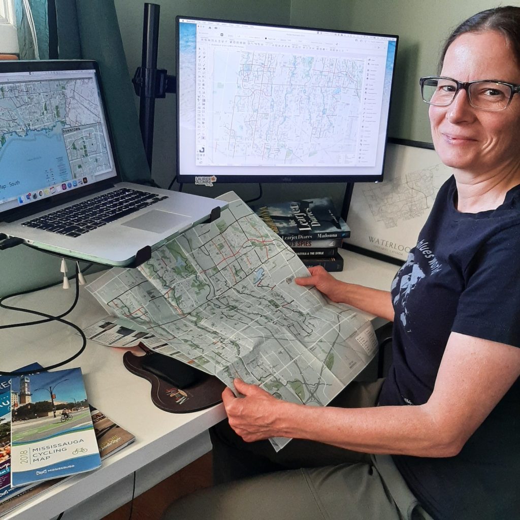
Julie Witmer’s road to cartography has not always taken the most conventional route, but in the past decade she’s already made her mark on the industry. As the owner of Julie Witmer Custom Map Design based in Kitchener, Ontario, Julie creates maps for a variety of client types, including municipalities, publications, and tourism. She applies her skills both in cartography and her previous fields of expertise to approach map-making in a way that encourages people to explore and connect with their communities. In this edition of Cartographer Chronicles we explore Julie’s story largely in her own words, including her journey to discovering a career in cartography, her experience with crafting maps so far, and how she envisions her business moving forward.

Portage La Prairie map by Julie Witmer using MAPublisher

Cartography became Julie’s third career path after a decade as an archaeologist and nearly 15 years in IT. 

“I’ve always loved maps – collecting them during my travels – but it never occurred to me that it was something you could do for a living. After I was laid off from BlackBerry in 2011, I decided to go back to school. And when I saw that Fleming College offered a GIS Cartography program, it was like a light turned on.”

After graduating from Fleming’s Cartographic Specialist program, Julie worked to build her cartography career the way she envisioned it.

“At Fleming when we talked about the kind of work we wanted to do, I kept saying ‘I just want to make pretty maps.’ I knew that I didn’t want to work in a cubicle farm or for a large company again, but I did work for almost a year for an archaeology company in London, Ontario, making a dozen maps a day for reports. It was hectic but I loved that it combined my interests.”

“I still wanted to work for myself and decided to be a freelancer. It was tough going for the first few years, but in the past 2-3 years (with a temporary slowdown for the first wave of the pandemic), my business has grown to what I envisioned.”

Vaughan Ontario map by Julie Witmer using MAPublisher

Julie has designed maps for a plethora of local and international clients spanning many different types of organizations, and she tailors her approach to fit each of them uniquely.

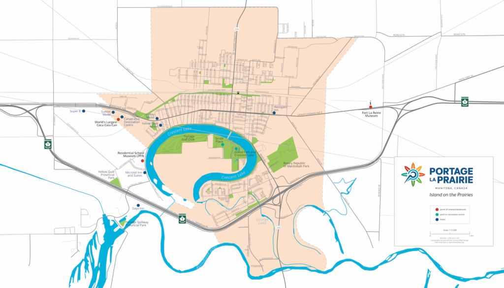
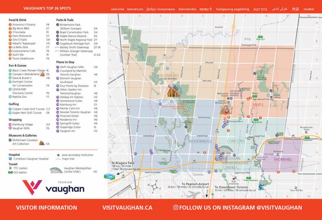
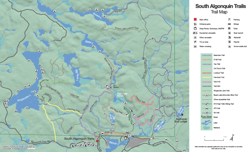
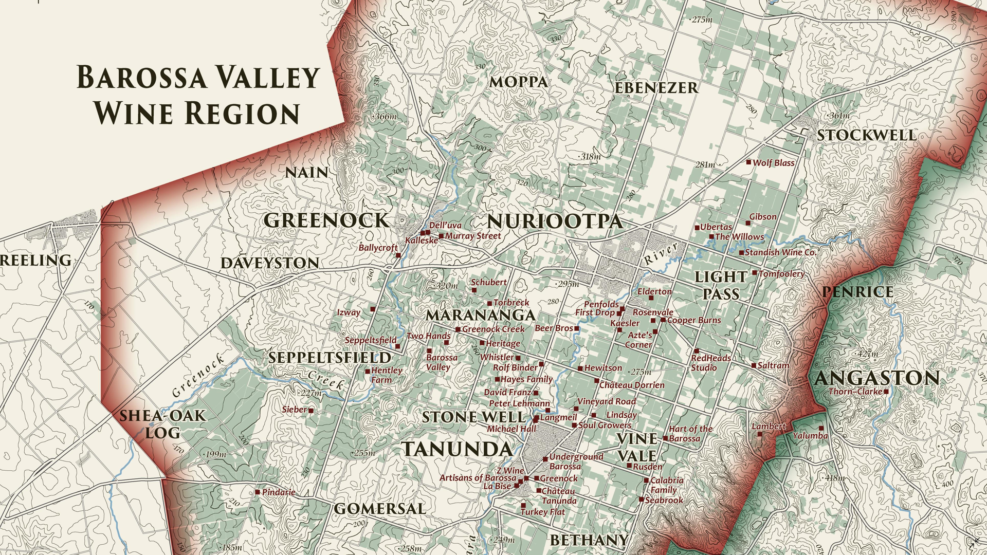
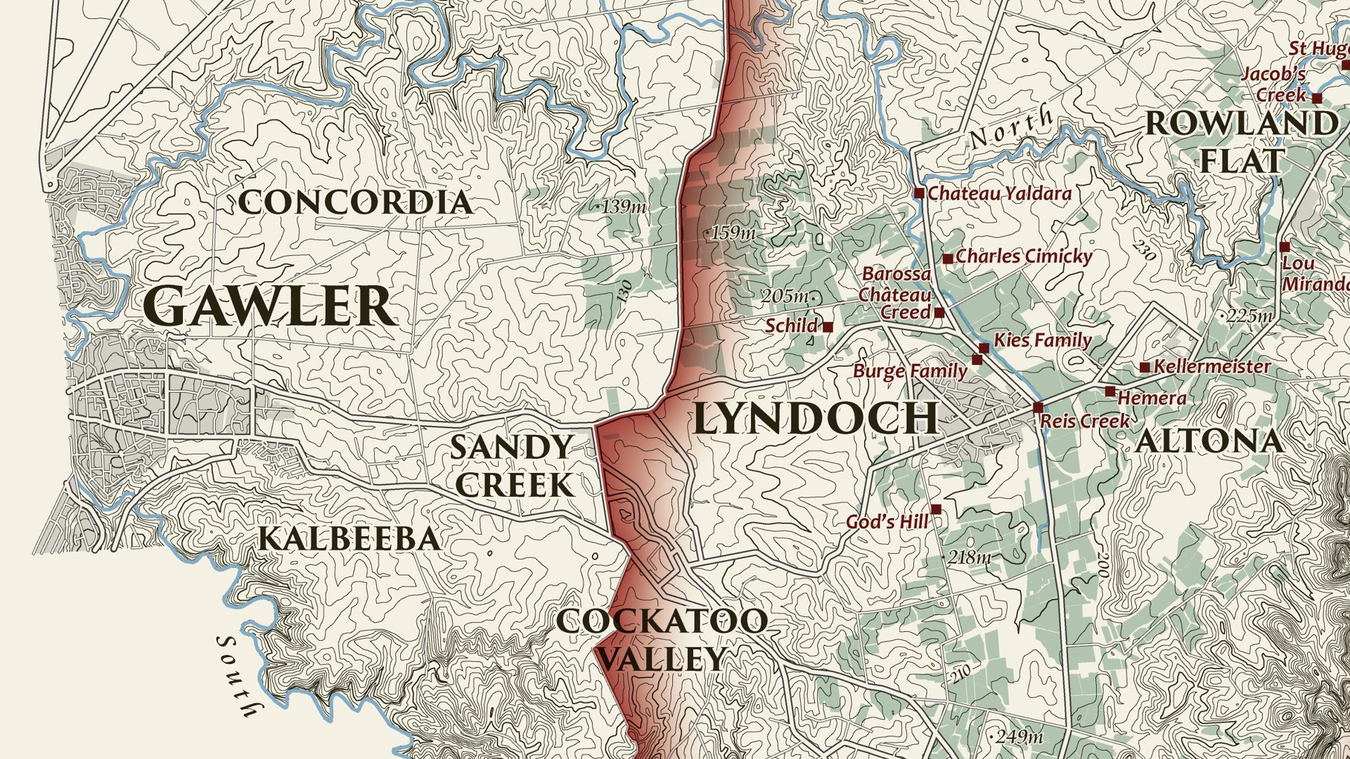
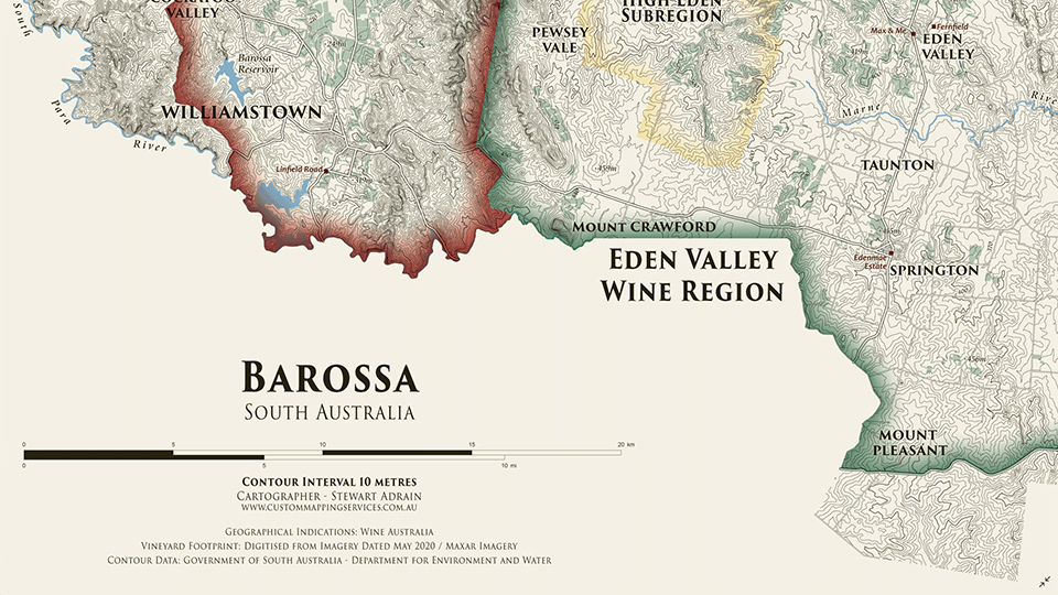
“Over the years I’ve worked on cycling maps for municipalities, tourism and trail maps for visitor guides and tourism-focused businesses, maps for non-profit organizations for planning and education, and a LOT of book maps.”

“When people contact me about making a custom map, I’ll arrange a project consultation to get more information about their project – content, style, size, media, timeline, the purpose of the map and its intended audience.”

South Algonquin trails map by Julie Witmer using MAPublisher

Many of Julie’s clients, especially municipalities, often come to her with their own datasets for her to use. If not, she’s a fan of Natural Earth or OpenStreetMap data.

“For [OSM data] I use QGIS and the QuickOSM plugin to download data for the coverage area. For everything else (Natural Earth, WFS or WMS services), I’ll grab the data in MAPublisher and spatially filter it to my map view.”

“I create a very simple layout map to establish the coverage area and scale, and then work on the first design draft. Sometimes we have a few revisions with minor style or content tweaks. When my client has approved the final draft, I send them the print-ready image files.”

Craft Gin trail map by Julie Witmer using MAPublisher

Julie is an avid and experienced MAPublisher user, as it plays a role in all of her projects. Her history with the program goes back to her time at Fleming.

“I first used MAPublisher at Fleming and I loved it! The archaeology company was an ESRI shop, but when I started my own business I went back to MAPublisher. I love that it’s a local company (well, almost local to me – in Toronto, just down the road from Kitchener). Avenza’s support is amazing, and they are constantly adding new features and incorporating feature requests from customers like me.”

“MAPublisher is the tool that I use most often, pretty much every day. Even if I use other tools to acquire and clip vector data, or manipulate raster images, everything ends up in MAPublisher where I do all the design work.”

She has begun using Avenza Maps in her work, both for collecting and recording data and offering her maps using the Avenza Map Store.

“I recently started creating local park facilities maps and adding them to Avenza Maps. I use the app to track my route while exploring these parks, because often the municipal or OSM datasets don’t include all the trails. I’ve encouraged my clients to use Avenza Maps, too. So far I’ve added a few cycling and tourism client maps to my vendor page, which provides a great value-add for end users.”

Kayak Shack map by Julie Witmer using MAPublisher

When asked about her favourite map that she has created, Julie finds it hard to answer that question with just one map!

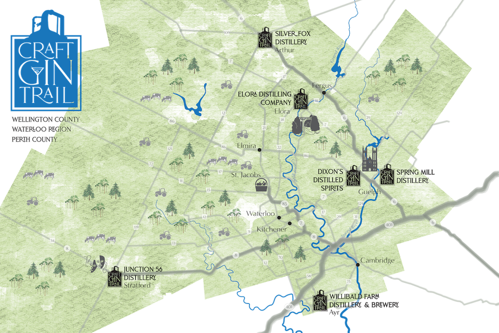
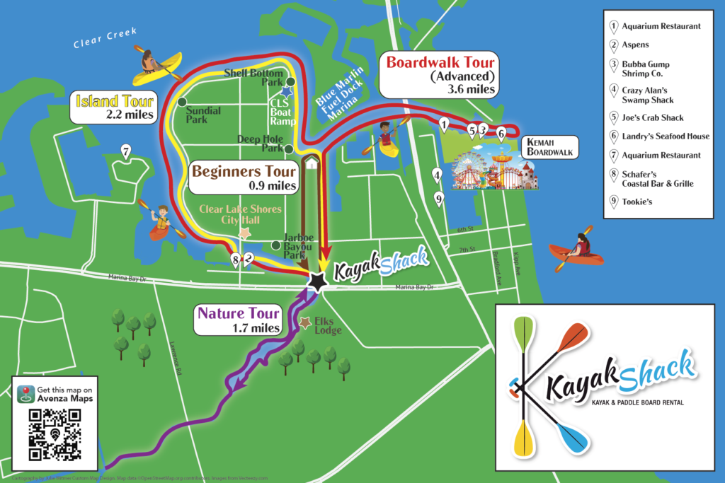
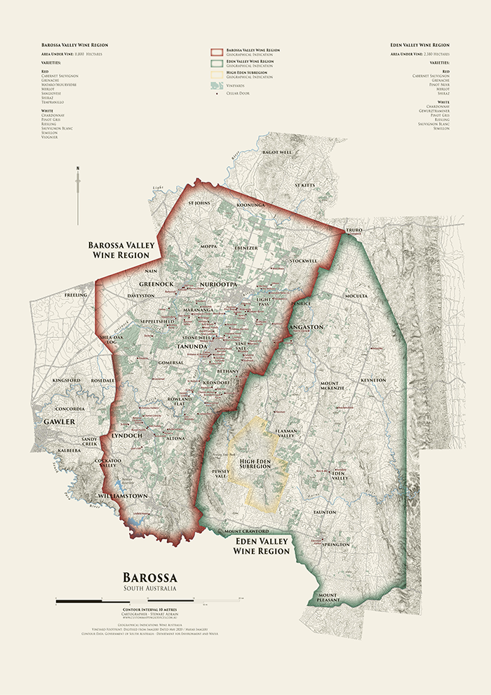
“It’s hard to pick a favourite map – it’s usually the one I’m working on. I’ve had fun creating a map of a motorcycle tour across the southwest US, a book map showing the route and shipwreck of a Dutch merchant ship, maps of the Roman Empire, a large poster map of Micronesia, a tour map for a kayak rental business, and a series of maps for a documentary film about an Indigenous nation in British Columbia. And so many others! I love when my clients give me free rein to come up with a design. But on the other hand, if my clients have a clear picture in their head, it’s very rewarding to bring that picture to life.”

Julie was kind enough to share with us some of the map projects we can expect to see from her in the near future, and other tasks she’s engaged in to streamline her map design process.

“Last year I worked on dozens of maps for an atlas of American history (coming soon), as well as quite a few projects for books, cycling and tourism maps, and more. Right now I’m working on a map of the eastern seaboard Fall Line; a map of the Gibraltar Nature Reserve for their website and brochure; city maps for Sharon, Pennsylvania; and several book map projects – military histories, historical fiction, maps of the Mediterranean and England, and the US midwest.”

“I’m [also] currently learning how to add FME to my workflow to help streamline some parts of the map creation process, and would like to play more with terrain imagery in Natural Scene Designer.”

Julie Witmer sitting at a computer using MAPublisher

Finally, Julie finished off our interview by providing advice for anyone wishing to pursue a career in freelance cartography like her.

“If you want to start your own cartography business, I would first recommend starting it part-time as a side hustle and building a portfolio and learning about marketing and everything else that goes with running your own business. I did it the hard way and there were many times that I thought about getting a salaried job, but I love what I do and I definitely didn’t want to end up back in a cubicle! For many years it felt like I had to keep my foot on the gas, working insane hours, but it’s finally paying off. It’s still harder than working for someone else, in some respects, but the rewards are worth it. I love being able to provide my clients with custom maps that show what’s important to them. And my boss lets me take more than 2 weeks of vacation!”

Learn about more about Julie by visiting her website!

Map Gallery Spotlight: Stewart Adrain

Map Gallery Spotlight Barossa Wine Regions Map by Stewart Adrain

We are showcasing another great submission from the 2021 Avenza Map Competition. This heritage-style decorative map of the Barossa Region of South Australia was created by Stewart Adrain of Custom Mapping Services. The map shows the wine regions, vineyards, cellar doors, and topography of the area. It is the final map in a series of heritage-style cellar wall maps Adrain has created of the wine-growing regions of South Australia. The Barossa Valley wine region is particularly notable for its Shiraz variety.

Adrain’s map uses 10-meter contours to display the topography of the Barossa region. Regional wineries are named and indicated on the map, with their locations shown by a point representing their cellar doors. The various localities of the Barossa region are also labelled, and the two main wine regions as well as the High Eden Subregion are displayed using colourful borders. The supplemental text of the map features the total area of vineyards in each wine region, as well as the wine varieties they produce. This map as well as the others in Adrain’s Cellar Wall map series can be purchased for print from Meridian Maps.

Select the images below to see a detailed look at Stewart’s map

Barossa Wine Regions Map snippet by Stewart Adrain

Making the Map

Adrain completed his data processing with QGIS and then used the Avenza MAPublisher plugin for Adobe Illustrator as a finishing tool to design the final map product. He used the Multiple Data Import tool to easily get all of his data into MAPublisher with a single import process. MAPublisher maintains the georeferencing of the data imported from other GIS software, so he could quickly turn his focus to the map’s stylization rather than data placement. Adrain used MAP Themes to easily achieve his stylization, which allowed him to automate much of the design process of the map, keeping the theme of this map in line with the other maps in the series.

Adrain simplified his labelling process by using our MAPublisher LabelPro add-on. This allowed him to create label themes based on the layer they were being applied to. Since this map was the last in the series, these themes were already created so he could simply import his settings from his previous maps to save time. The LabelPro feature is convenient for both time-saving purposes and ensuring consistency across maps in a series.

Finally, Adrain added a scale bar using MAPublisher and completed the finishing touches to his map with native Adobe Illustrator tools.

For more information on using the MAPublisher LabelPro add-on, please visit our Support Centre section for this tool. Check out our other Map Gallery Spotlight blogs here!

MAPublisher Virtual Training: March 6-8, 2023

Whether you’re new to MAPublisher®, an experienced user, or simply thinking about a purchase, Avenza software training is a worthwhile experience. Get hands-on training from Avenza product specialists at one of our training courses around North America or virtually from anywhere.

No Fields Found.

MAPublisher Virtual Training: June 12-14, 2023

Whether you’re new to MAPublisher®, an experienced user, or simply thinking about a purchase, Avenza software training is a worthwhile experience. Get hands-on training from Avenza product specialists at one of our training courses around North America or virtually from anywhere.

No Fields Found.

MAPublisher Virtual Training: April 24-26, 2023

Whether you’re new to MAPublisher®, an experienced user, or simply thinking about a purchase, Avenza software training is a worthwhile experience. Get hands-on training from Avenza product specialists at one of our training courses around North America or virtually from anywhere.

No Fields Found.

Formation en ligne inter-entreprise sur MAPublisher: 5-9 décembre 2022

Que vous soyez un professionnel des SIG ou que vous débutiez tout juste dans le domaine, cette formation vous propose de prendre en main MAPublisher® de manière approfondie! Rejoignez nos amis de Géom@tique du 5 au 9 décembre pour cette formation en ligne! Les inscriptions et plus d’informations sont disponibles sur leur site web.


Whether you’re new to GIS or an experienced user, this course will give you an in-depth introduction to MAPublisher® in French! Join our friends at Géom@tique from December 5th to 9th for this online training! Sign ups and more information are available on their website.

Formation en ligne inter-entreprise sur MAPublisher: 22-26 mai 2023

Que vous soyez un professionnel des SIG ou que vous débutiez tout juste dans le domaine, cette formation vous propose de prendre en main MAPublisher® de manière approfondie! Rejoignez nos amis de Géom@tique du 22 au 26 mai pour cette formation en ligne! Les inscriptions et plus d’informations sont disponibles sur leur site web.


Whether you’re new to GIS or an experienced user, this course will give you an in-depth introduction to MAPublisher® in French! Join our friends at Géom@tique from May 22nd to 26th for this online training! Sign ups and more information are available on their website.

News Archive