


Whether you’re new to Avenza Maps®, an experienced user, or simply thinking about a purchase, Avenza Maps training is a worthwhile experience. Get hands-on training from Avenza product specialists at one of our training courses online virtually from anywhere.
Articles
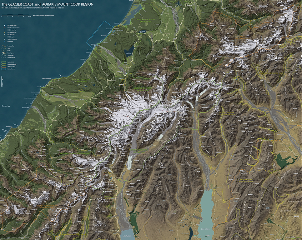
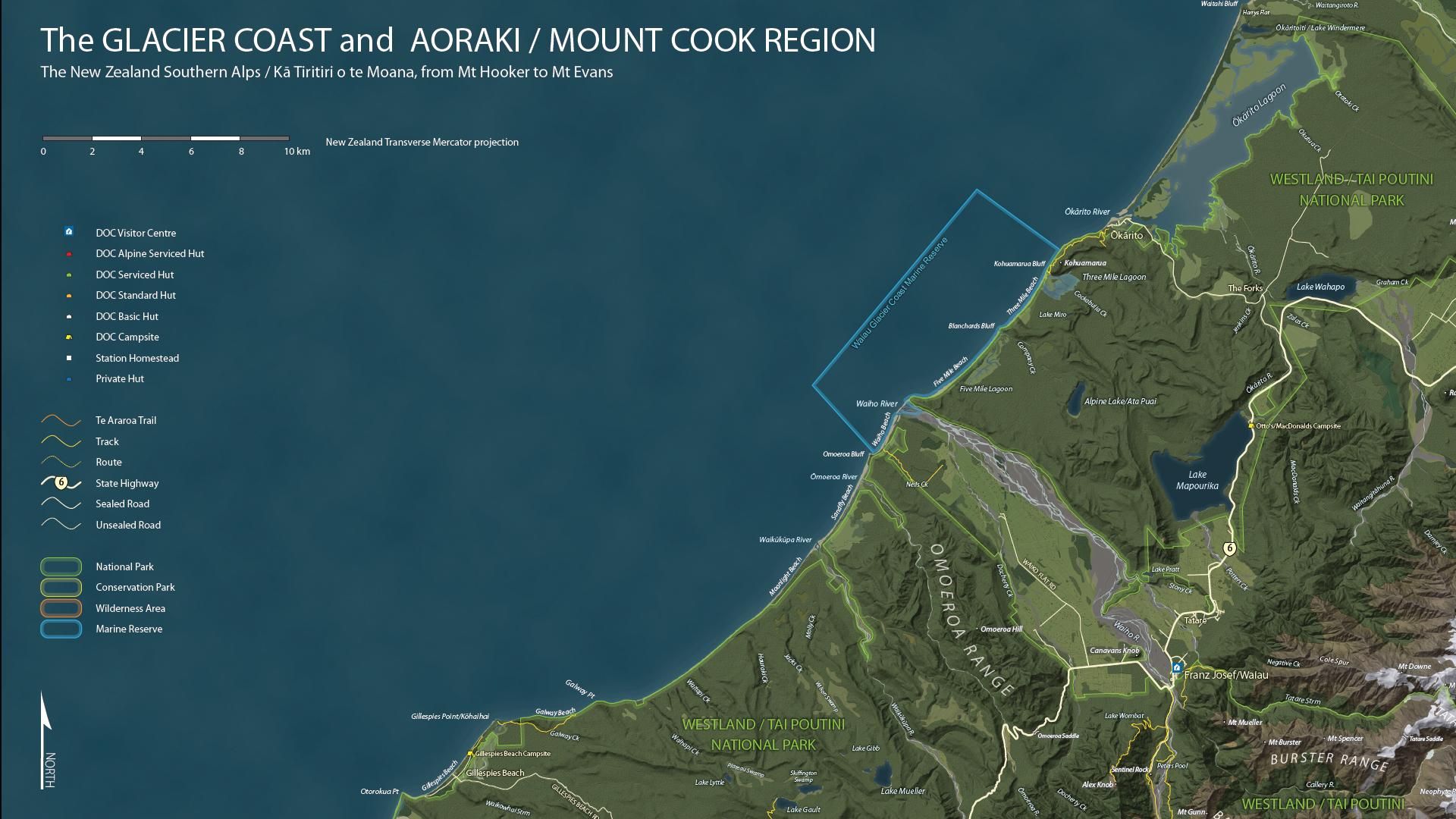
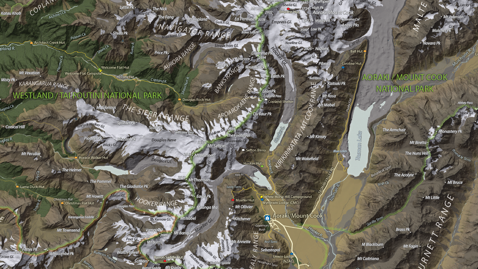
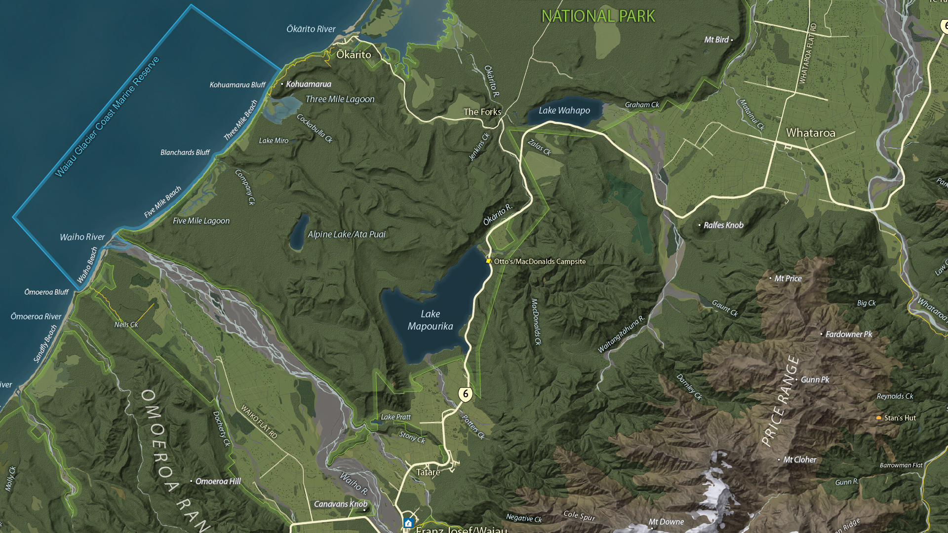
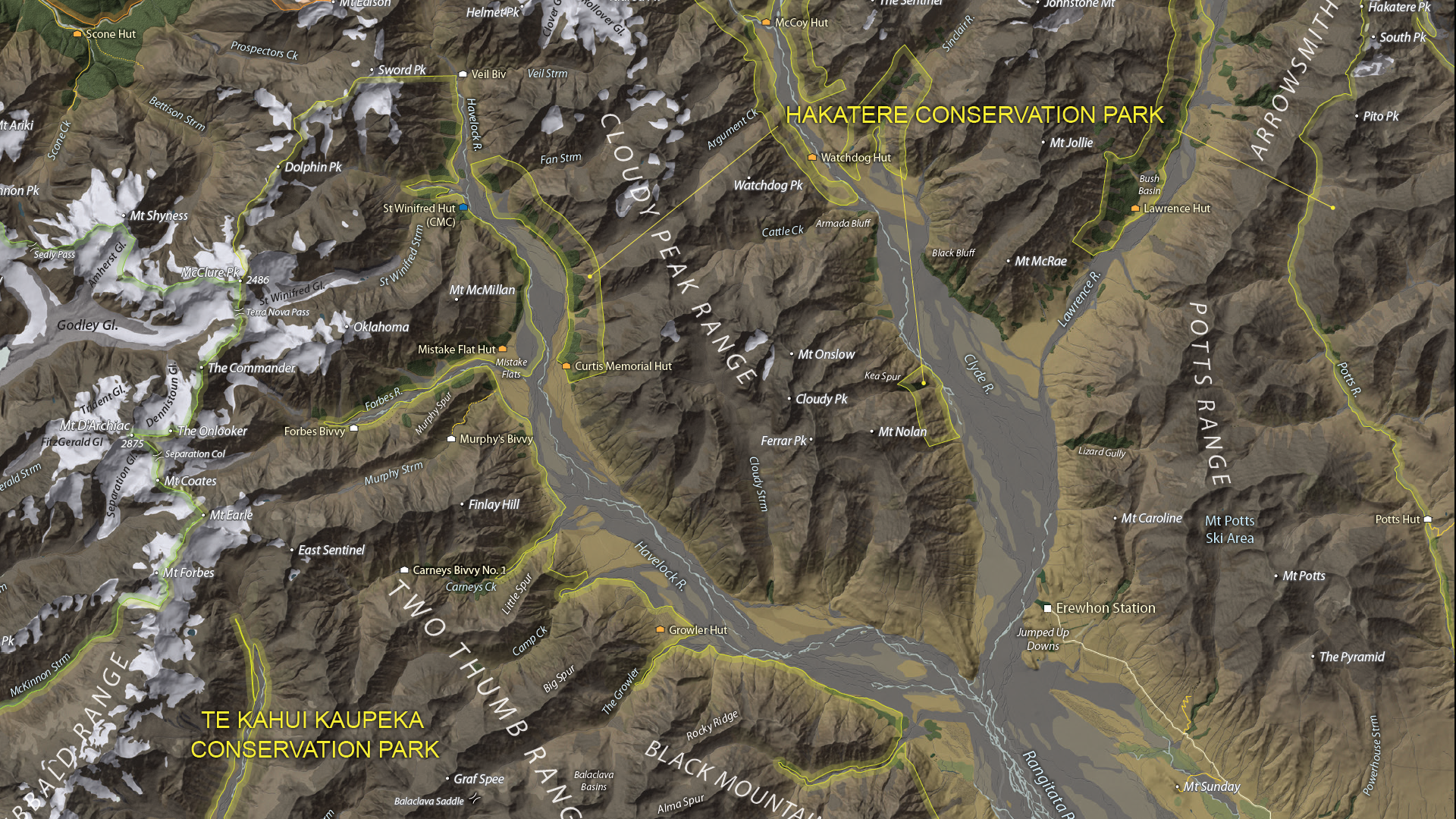
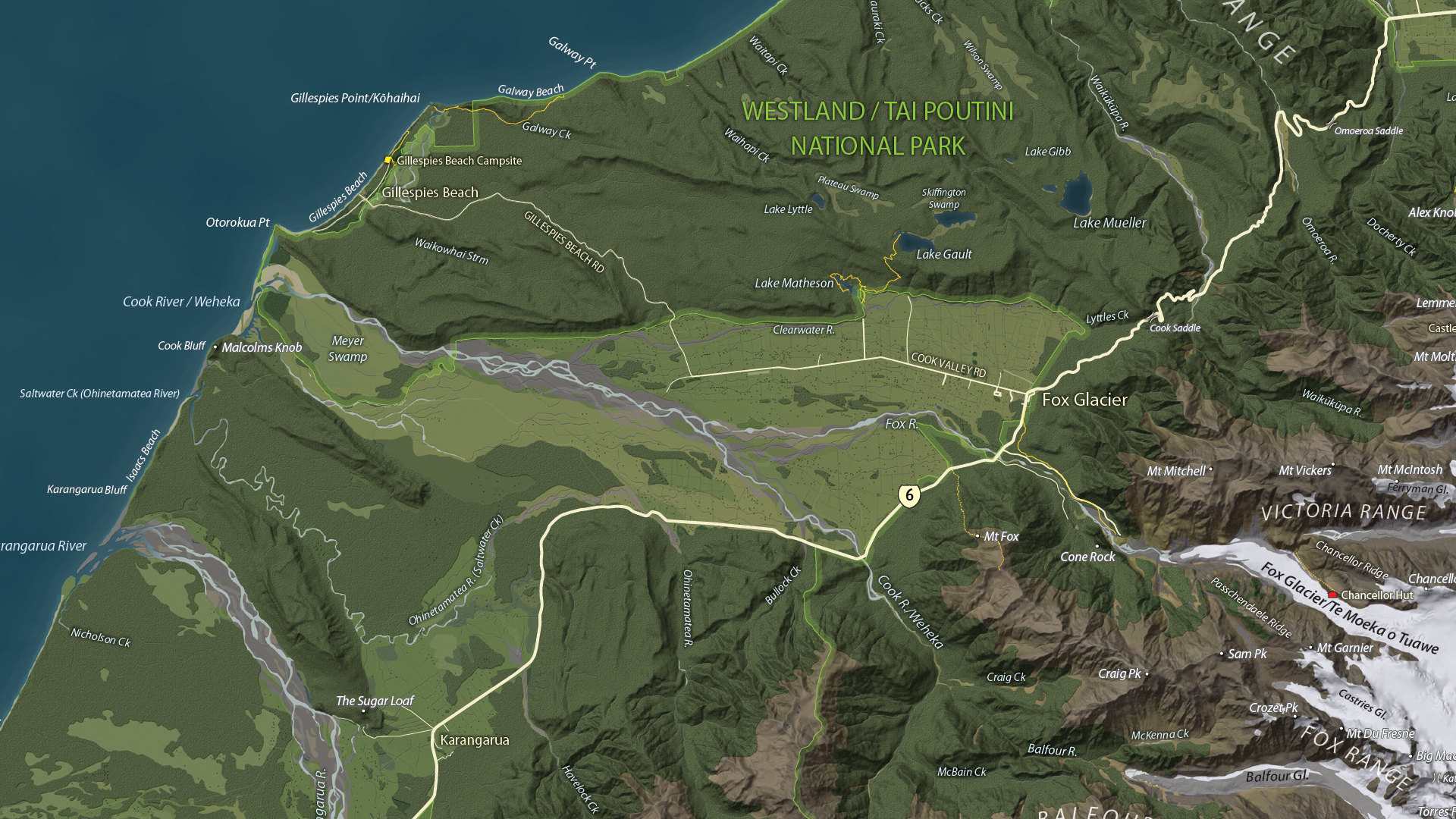
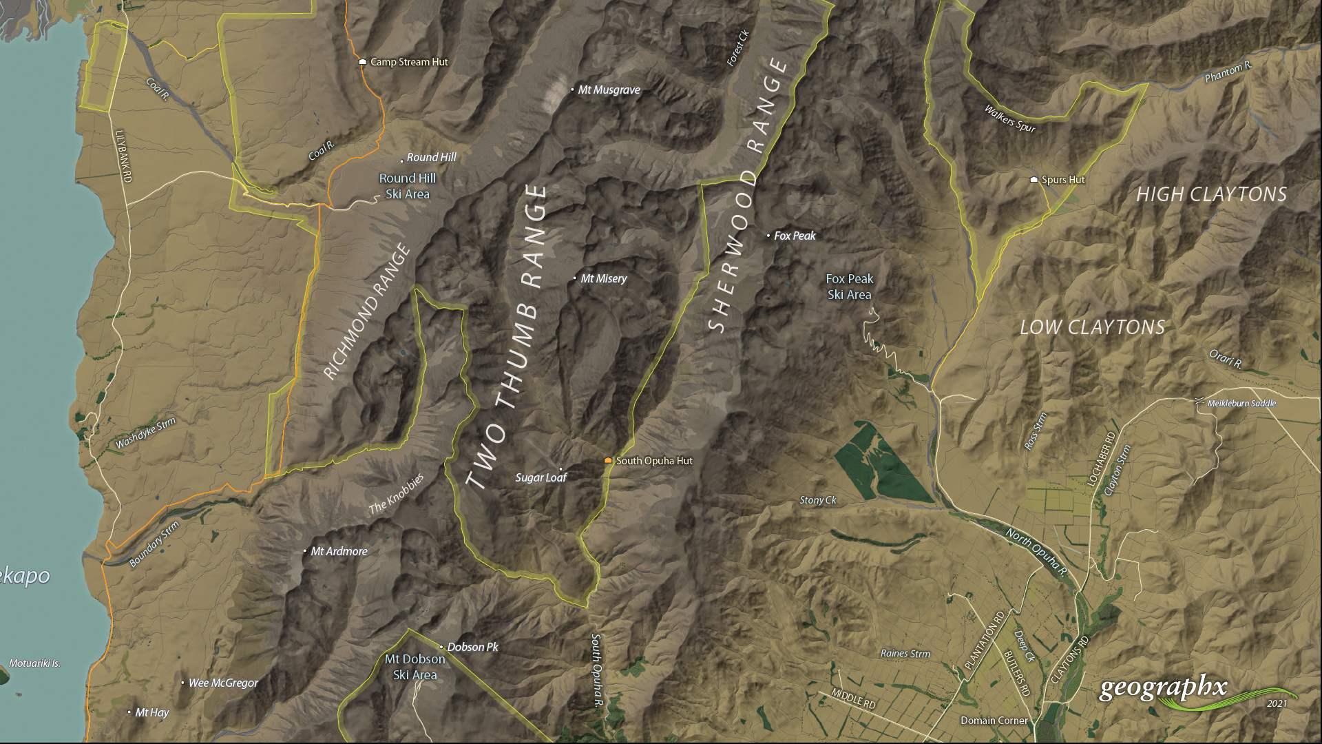
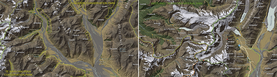
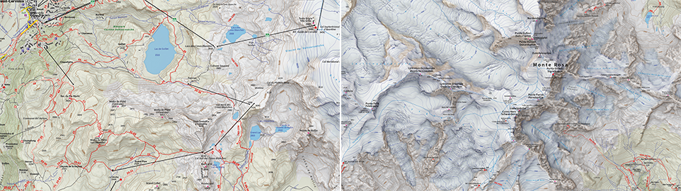
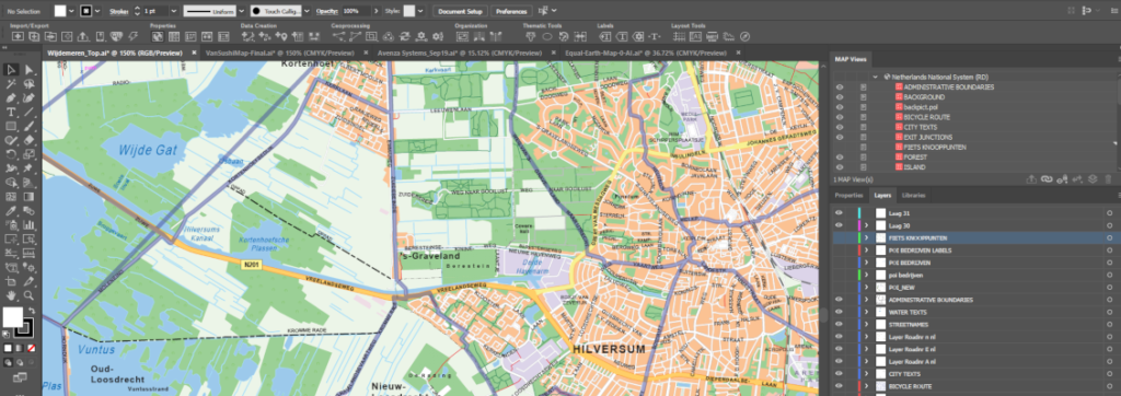
Whether you’re new to MAPublisher®, an experienced user, or simply thinking about a purchase, Avenza software training is a worthwhile experience. Get hands-on training from Avenza product specialists at one of our training courses around North America or virtually from anywhere. Whether you’re new to Avenza Maps®, an experienced user, or simply thinking about a purchase, Avenza Maps training is a worthwhile experience. Get hands-on training from Avenza product specialists at one of our training courses online virtually from anywhere. Whether you’re new to MAPublisher®, an experienced user, or simply thinking about a purchase, Avenza software training is a worthwhile experience. Get hands-on training from Avenza product specialists at one of our training courses around North America or virtually from anywhere. Que vous soyez un professionnel des SIG ou que vous débutiez tout juste dans le domaine, cette formation vous propose de prendre en main MAPublisher® de manière approfondie! Rejoignez nos amis de Géom@tique du 19 au 23 mai pour cette formation en ligne! Les inscriptions et plus d’informations sont disponibles sur leur site web. Whether you’re new to GIS or an experienced user, this course will give you an in-depth introduction to MAPublisher® in French! Join our friends at Géom@tique from May 19th to 23rd for this online training! Sign ups and more information are available on their website. We are showcasing the Open-category winner of the 2021 Avenza Map Competition. This fantastic entry was created by Roger Smith, expert cartographer and owner of Geographx in Wellington, New Zealand. Roger’s grand-prize winning entry is a truly remarkable display of map craftsmanship. The map provides a detailed look at the topography and trail coverage surrounding one of New Zealand’s most beautiful wilderness areas. His expert usage of natural colour basemaps and shaded relief creates a truly stunning result. This topographic map focuses on the area covered by Westland Tai Poutini National Park, Aoraki/Mount Cook National Park, and the adjacent conservation parks and designated wilderness areas. It presents park boundaries, back-country walking trails, and the many camping shelters that are scattered throughout the area. The map itself is designed for print as a wall map and utilizes a natural colour basemap to create an eye-catching visual guide for the region. The map can be used to familiarize park visitors with the area and assist recreational visitors with trip-planning in the rugged back-country trails of the area. The natural colour basemap is designed to maximize viewer understanding and appreciation of the physical environment while providing a pleasing backdrop that highlights important points, trails and places on the map. Select the images below to see a detailed look at Roger’s map The cartographic design elements and vector art creation utilized a wide range of tools in MAPublisher. Some of the vector data that went into the map were obtained through the New Zealand Department of Conservation, and the Land Information Department, while others were custom-crafted by Roger and his team at Geographx. Notably, the Geographx team custom-built the natural colour basemap and DEM-derived hillshade that gives the map its unique look and feel. MAPublisher allowed Roger to import his data layers into an Adobe Illustrator environment that was conducive to flexible cartographic design work. Using the MAP Views panel, he could easily adjust and modify the projection and scaling of his map. Where necessary, Roger leveraged the many MAPublisher Geoprocessing and Data Editing tools to manipulate or simplify vector art layers for better representation on the final map. As MAPublisher maintains spatial referencing for each data layer, he could place and register his custom natural colour, and raster hillshade layers to create his basemap. Fine-tuning would ensure his vector layers (including roads, campsites, trails, and place markers) would all be accurately placed and aligned with their real-world locations. Roger created unique labels for the hundreds of different placemarks and trail lines on the maps. Using MAP Attribute data that are retained for each data layer, Roger used the Label Features tool to efficiently create and place labels for each layer. With Label Features, Roger could define custom rules that ensure each label stands apart from the other. For important place markers and points of interest, Roger used the Create Halos tool to make certain labels stand out more prominently. Needless to say, this spectacular piece of work represents the culmination of countless hours of design effort and dedication. Roger has added this map to the impressive collection of cartographic works produced by Geographx. To learn more about other fantastic map products available from Geographx, visit their website. We’re excited to announce that the 2021 Avenza Map Competition has now concluded. This past year’s competition saw map-makers and cartographers from around the world submit their best and most impressive work. We had some truly impressive displays of cartographic design this year, with competitors demonstrating how they use Avenza mapping software to make eye-catching and impactful cartographic products. After multiple rounds of judging, discussions, and time spent reviewing our scorecards, the Avenza team would like to congratulate this year’s prize winners! Over the next few weeks, keep an eye out for our Winner’s Spotlight articles. Each article will provide an in-depth look at the winning map entries, with insights from their creators, and an overview of tools and techniques used to develop their prize-winning maps. The winner’s maps and a selection of honourable mentions will also be showcased in the new Map Gallery, coming soon! Learn more about Roger’s winning map entry in the Winners Spotlight Article Learn more about 4LAND’s winning map entry in their Winners Spotlight Article The judges would also like to offer special recognition to a number of other incredible entries. A selection of winners, honourable mentions, and notable map entries will be showcased on the upcoming Map Gallery page. In collaboration with the British Cartographic Society, we are delighted to announce the opening of the Avenza Award for Electronic Mapping, part of a series of cartographic awards of excellence made available this year. Through this award, Avenza is proud to provide recognition of stellar effort and outstanding achievement in the realm of digital cartography. Open to any map available in electronic format, including interactive digital maps, internal GIS map applications, and maps for presentations. The Avenza Award for Electronic Mapping comprises a trophy and a certificate which will be presented at the British Cartographic Society Annual Conference. The deadline for all submissions is June 27th, 2022. Entries are encouraged from those engaged in all aspects of map-making – practical, theoretical, commercial, and academic – using traditional or innovative techniques and research. For full competition rules and to submit your entry, please visit the British Cartographic Society awards page. We are very excited to announce the release of MAPublisher 11, the latest version of our MAPublisher extension for Adobe Illustrator. With MAPublisher 11, we are bringing forward full compatibility with the Apple Silicon processor, enhancements to the MAP Attributes panel, a revamped welcome screen, the ability to import OpenStreetMap file formats, a brand new set of MAP Erase tools, and several performance and bug fixes. Here’s what you can expect with the latest MAPublisher 11 release: We want to ensure our users enjoy a truly seamless experience whether they are using a PC or Mac computer. Our team has worked to ensure that MAPublisher 11 is fully compatible with the Apple Silicon chip, and as such we can declare that MAPublisher is officially supporting this processor. An exciting feature for MAPublisher 11 is a number of enhancements made to the MAP Attributes panel. Users are no longer required to select all objects on a layer for them to appear in the MAP Attribute panel. Instead, all features appear by default, and users can toggle between showing all features or just their selected features at the bottom left corner of the panel. When all features are shown, selected features will appear highlighted in the attribute table. MAPublisher 11 comes with a brand new welcome screen that appears upon opening the program. This window is equipped with visually appealing refreshed graphics, while maintaining access to the License Management window. It also features several new sections that increase discoverability for you, such as new features, help and tutorials, and other Avenza news or events. There is also a Get Inspired section to help inspire you as a mapmaker, which features articles from our website which highlight the excellent maps and stories of some of our most proficient users. We are thrilled to announce that importing OpenStreetMap (OSM) file formats is now a possibility with MAPublisher 11! Whether you are importing a single file, or using the Multiple Data Import tool you can now select OSM and PBF file formats from the list of supported formats. The rest of the import process remains unchanged from the other file formats users are familiar working with in MAPublisher. Many of our users have requested the ability to quickly erase unwanted or sensitive data from their maps. Thus, we are happy to introduce the new MAP Vector Erase and MAP Erase by Shape tools that come along with MAPublisher 11! With the new release of MAPublisher 11 comes a new tool known as the MAP Vector Erase tool. Functioning as an inverse version of the MAP Vector Crop tool, the Erase tool removes all data within a specified rectangle or ellipse shape. The new MAP Erase by Shape tool functions similarly to the MAP Vector Erase tool, but it allows users to easily erase portions of MAP Layers using shapes other than rectangles and ellipses. Users can simply select the shape object they wish to use as the erase boundaries, and then select the MAP Erase by Shape tool from the MAP Toolbar. Both tools share the same customizable settings and advanced options. Like the MAP Crop tools, the MAP Erase tools can be applied to all layers within the document, all layers within a single MAP View, or just a single layer. If you would like to learn more about the new MAPublisher 11 features or have any questions, please check out our Support Centre. MAPublisher 11 is immediately available today, free of charge to all current MAPublisher users with active maintenance subscriptions and as an upgrade for non-maintenance users. When it comes to map-making for beginners, one of the most challenging aspects is finding the right data in the first place. You start out with this fantastic idea for mapping the annual airplay frequency of Mariah Carey on traditional radio… only to find the data behind a paywall. What’s with that? Turns out, it’s very common. Data is commonly referred to as the most valuable resource on the planet for a reason. Companies make a lot of money by collecting data and selling it or selling indirect access to it. So, before you get too excited about an idea, take a step back and think about the data. There are a lot of reasons why paying for data may not be an option for you and we’re not here to judge, so moving along. When you’re not able to pay for data, you’ll need to be less choosy about what you’re creating. This type of data hunting is a more broad search, find some data, then let it speak to you! You may need to be a bit more creative, but free data is out there and if you’re willing to dig you can still create wonderful maps with it! The first thing to consider with how to find data is where in the world are you looking for it. Developed countries often give public access to census data or other government-funded research. This can often be the most reliable data as well. Something to consider when thinking about the data you’re looking for. The size of your project scope can also have a big impact on where you try and find data. If you’re looking for data only on one country, that will be a lot easier to find (in general) than the same data for every country in the world. You can often find high-level data (think population) at a national global level, but if you go more granular (think language spoken) it could get more difficult to find. There also would be a lot more variables if you chose language spoken globally, this could affect how you ultimately portray the data. Another consideration is from which point in time you want to collect data. Depending on when in history you’re looking, it can be either very difficult or very easy to find data. Keep in mind that this changes when you look at different countries around the world. In general, anything in the 1900s forward in developed countries should have some data. But depending on when specifically and what you’re looking for there could be a lot of range. This ultimately goes back to the point made above about letting the data guide you. You may not be able to create the exact map you thought you were going to create when you started thinking about the project. Often you’ll find you come up with something even better! Still don’t know where to start? Try some of these helpful links for easily accessible data! Whatever Adobe environment you prefer to work in, Avenza has a solution for you! Avenza MAPublisher is cartography software that seamlessly integrates more than fifty GIS mapping tools into Adobe Illustrator to help you create beautiful maps. Whereas Avenza Geographic Imager mapping software enhances Adobe Photoshop to make working with spatial imagery quick and efficient. Download your free trial of MAPublisher or Geographic Imager today!
MAPublisher Virtual Training: February 19-21, 2025
Avenza Maps Virtual Training: March 5-6, 2025
MAPublisher Virtual Training: March 18-20, 2025
Formation en ligne inter-entreprise sur MAPublisher: 19-23 mai 2025

Map Gallery Spotlight: Roger Smith
Making the Map
Announcing the Avenza Map Competition 2021 Winners
Grand Prize Winner (Open Category)
The Glacier Coast and Aoraki/Mount Cook Region
Roger Smith
Geographx
Wellington, New Zealand
Runner-Up (Open Category)
A Topographic Reference Map of the Monte Rosa Area
Remo Nardini and the 4LAND Team
4LAND
Bolzano, Italy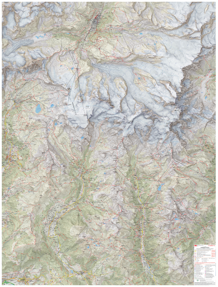
Coming Soon: Avenza Map Competition Gallery
British Cartographic Society: Avenza Award for Electronic Mapping

The competition is now open!
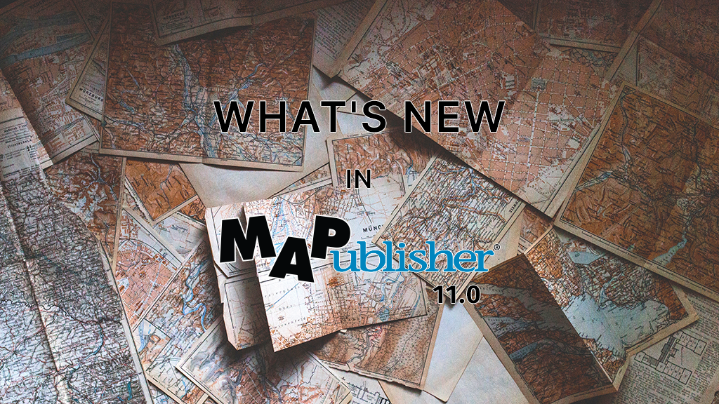
What’s New in MAPublisher 11.0 for Adobe Illustrator?
Compatibility with the Apple Silicon Processor
MAP Attributes Panel Enhancements
Welcome Screen Revamp
Importing OpenStreetMap File Formats
MAP Erase Tools
MAP Vector Erase Tool
MAP Erase by Shape Tool
How to Find Data
Finding Data in a Big Data World
Where to Find Data

Think Where

Think How Big
![]()
Think When
Helpful Links
Wherever you find it, Use Avenza Systems to Create It!


