My Account     Contact Us     Cart

Avenza Releases MAPublisher 11.0 for Adobe Illustrator

Toronto, ON, August 31, 2022 – Avenza Systems Inc., producers of the Avenza Maps® app for mobile devices and geospatial extensions for Adobe Creative Cloud®, including Geographic Imager® for Adobe Photoshop®, is pleased to announce the release of MAPublisher® 11.0 for Adobe Illustrator®. This version offers full compatibility with the Apple Silicon processor, enhancements to the MAP Attributes panel, a revamped welcome screen, the ability to import OpenStreetMap file formats, a brand new set of MAP Erase tools, and several performance improvements and bug fixes.

MAPublisher cartography software seamlessly integrates more than seventy GIS mapping tools into Adobe Illustrator to help you create beautiful maps from geospatial data. Import industry-standard GIS data formats and make crisp, clean maps with all attributes and georeferencing intact using the Adobe Illustrator design environment.

New major features of the MAPublisher 11.0 extension for Adobe Illustrator include:

  • Apple Silicon Processor compatibility
  • MAP Attributes Panel enhancements: Users no longer need to select all attributes for them to appear by default in the features list, with show all/show only selected features toggle buttons
  • Welcome Screen revamp: Improved discoverability for users with more content to aid in getting started or inspired with MAPublisher 
  • OpenStreetMap file format support: Import OpenStreetMap OSM and PBF file formats
  • MAP Erase tools: Quickly remove sensitive or unwanted data from maps with the MAP Vector Erase or MAP Erase by Shape tools

Users require a valid Adobe Creative Cloud subscription and a compatible operating system to utilize the improvements and enhancements offered in MAPublisher 11.0. For questions and information on how compatibility requirements may affect your organization, please contact our Support Centre.

MAPublisher 11.0 is immediately available free of charge to all current MAPublisher users with active maintenance and as an upgrade for non-maintenance users starting at US$649. New licenses are available from US$1499. MAPublisher FME-Auto and MAPublisher LabelPro are also available as add-ons starting at US$499. Academic, floating, and volume licenses are also available. Prices include one year of full maintenance. Read more about MAPublisher 11.0 in the release blog, or visit www.avenza.com/mapublisher for more details.

More about Avenza Systems Inc.

Avenza Systems Inc. is an award-winning, privately held corporation that provides cartographers and GIS professionals with powerful software tools to make better maps. Avenza also offers the mobile Avenza Maps app to sell, purchase, distribute, and use maps on iOS and Android devices.
For further information contact: 416-487-5116 – info@avenza.comwww.avenza.com

What’s New in MAPublisher 10.9 for Adobe Illustrator?

What's New in MAPublisher 10.9 Header

We are very excited to announce the release of MAPublisher 10.9, our latest version of the MAPublisher extension for Adobe Illustrator. 

With MAPublisher 10.9, we are bringing forward full compatibility with Adobe Illustrator 2022, Windows 11, macOS 12, support for Vector GeoPackages and TopoJSON data formats, improvements to the Buffer Art tool, and several bug fixes.

Here’s what you can expect with the latest MAPublisher 10.9 release:

Compatibility with Adobe Illustrator 2022, Windows 11, and macOS 12

We want to ensure our users enjoy a truly seamless experience with the Adobe Illustrator workspace. Our team has worked to ensure that MAPublisher 10.9 is fully compatible with Adobe Illustrator 2022 that was announced at Adobe Max last week. 

MAPublisher 10.9 is also fully compatible with the newly released Windows 11, as well as macOS 12 Monterey.

Import TopoJSON data

New to MAPublisher 10.9 is the ability to import TopoJSON type data formats directly into Adobe Illustrator. A TopoJSON is built off the GeoJSON data format in a way that encodes topology. Geometries in TopoJSON files are collected together from shared line segments called arcs. In this way, TopoJSON data formats can reduce redundancies and improve storage efficiency for spatial data.

What's New in MAPublisher: Import TopoJSON data

Import and Export Vector GeoPackages

Many of our users have requested the ability to import and export vector GeoPackage data. We are happy to announce the full support of vector GeoPackages is now offered with MAPublisher 10.9. Vector GeoPackages are based on SQLite databases and offer an open-source, compact, lightweight, and flexible data format for easy and efficient storage or geoprocessing of spatial data.

Geodesic Options for the Buffer Art Tool

Geodesic options are now available for the Buffer Art tool. This functionality will provide more accurate distance buffers for point data when working on features distant from lines of true scale. Find this option in the “method” section of the Buffer Art tool.

What's New in MAPublisher: MAPublisher Buffer Tool

Default Data filters and Styles on import

MAPublisher 10.9 users can create unique data filters and style settings that can be automatically applied to newly imported data in MAPublisher.

Changes to Compatibility

Avenza announces that compatibility support is changing for its desktop mapping software. Starting with MAPublisher 10.9, both Windows 7 and Adobe CS6 will no longer be supported. Users will require a valid Adobe Creative Cloud subscription and a compatible operating system to utilize the improvements and enhancements offered in MAPublisher 10.9. For questions and more information on how these changes around compatibility may affect your organization, please contact our Support Centre.

MAPublisher 10.9 is immediately available today, free of charge to all current MAPublisher users with active maintenance subscriptions and as an upgrade for non-maintenance users. 

Enter the Avenza Map Competition!

The Avenza Map Competition is live! Enter our map competition for a chance to showcase your favourite maps with the Avenza community and win prizes! The competition consists of two categories: “Open” and “Student”, with two sets of exciting prizes. Submit your Map today!

Avenza Map Competition

Avenza Releases MAPublisher 10.9 for Adobe Illustrator

Toronto, ON, November 9, 2021 – Avenza Systems Inc., producers of the Avenza Maps® app for mobile devices and geospatial extensions for Adobe Creative Cloud®, including Geographic Imager® for Adobe Photoshop®, is pleased to announce the release of MAPublisher® 10.9 for Adobe Illustrator®. This version offers compatibility with Adobe Illustrator 2022, Windows 11, and macOS 12. It also provides a variety of feature updates including the widely requested support for the vector GeoPackage and TopoJSON data formats, new Geodesic options for the Buffer Art tool, default filter on import and style on import options, and several performance improvements and bug fixes.

MAPublisher cartography software seamlessly integrates more than seventy GIS mapping tools into Adobe Illustrator to help you create beautiful maps from geospatial data. Import industry-standard GIS data formats and make crisp, clean maps with all attributes and georeferencing intact using the Adobe Illustrator design environment.

New major features of the MAPublisher 10.9 extension for Adobe Illustrator include:

  • Adobe Illustrator 2022 compatibility
  • Windows 11 and macOS 12 Monterey compatibility
  • TopoJSON support: Import TopoJSON data
  • GeoPackage support: Import and export vector GeoPackage data 
  • Geodesic Buffer settings: Provides more accurate distance buffers on point data when working on features distant from lines of true scale
  • Default import filters and styles: Specify default options for filtering and displaying data that is imported into MAPublisher

Avenza announces that compatibility support is changing for its desktop mapping software. Starting with MAPublisher 10.9, both Windows 7 and Adobe CS6 will no longer be supported. Users will require a valid Adobe Creative Cloud subscription and a compatible operating system to utilize the improvements and enhancements offered in MAPublisher 10.9. For questions and more information on how these changes around compatibility may affect your organization, please contact our Support Centre.

MAPublisher 10.9 is immediately available free of charge to all current MAPublisher users with active maintenance and as an upgrade for non-maintenance users starting at US$649. New licenses are available from US$1499. MAPublisher FME-Auto and MAPublisher LabelPro are also available as add-ons starting at US$499. Academic, floating, and volume licenses are also available. Prices include one year of full maintenance. Read more about MAPublisher 10.9 in the release blog, or visit www.avenza.com/mapublisher for more details.

More about Avenza Systems Inc.

Avenza Systems Inc. is an award-winning, privately held corporation that provides cartographers and GIS professionals with powerful software tools to make better maps. Avenza also offers the mobile Avenza Maps app to sell, purchase, distribute, and use maps on iOS and Android devices.

For further information contact:  416-487-5116 – info@avenza.comwww.avenza.com

Adobe MAX 2021: Exciting Improvements for Avenza Mapping Plugins

Toronto, CA (October 26, 2021) – Avenza Systems Inc., producers of the Avenza Maps® app for mobile devices is pleased to announce the upcoming releases of MAPublisher® 10.9 for Adobe Illustrator® and Geographic Imager® 6.5 for Adobe Photoshop® 2022 These updates will provide a range of user interface improvements, feature enhancements, bug fixes, and performance upgrades, along with compatibility with the latest Adobe Creative Cloud applications.

Data-driven Map Design in Illustrator with MAPublisher

MAPublisher cartography software seamlessly integrates more than seventy GIS mapping tools into Adobe Illustrator to help you create beautiful maps from GIS data. Import industry-standard GIS data formats and make crisp, clean maps with all attributes and georeferencing intact using the Adobe Illustrator design environment.

Expected new features of the MAPublisher 10.9 extension for Adobe Illustrator include support for import and export of vector Geopackages, import of TopoJSON files, new “Geodesic” buffers, a default simplification setting, bug fixes, user interface enhancements, and much more.

Powerful Imagery Editing in Photoshop with Geographic Imager

Geographic Imager for Adobe Photoshop delivers an all-encompassing solution to import, edit, and export geospatial images such as aerial and satellite imagery. Work with digital elevation models, GeoTIFFs, and other popular GIS image formats while using Adobe Photoshop features such as transparencies, filters, cropping, and image adjustments; all while maintaining georeferencing and support for hundreds of coordinate systems and projections

Expected improvements of the Geographic Imager 6.5 extension for Adobe Photoshop include functionality enhancements for several tools, performance improvements, bug fixes, and more. Additional feature upgrades to be announced soon.

Upgrade or Purchase 

MAPublisher 10.9 will be available free of charge to all current MAPublisher users with active maintenance and as an upgrade for non-maintenance users starting at US$649. New licenses are available from US$1499. MAPublisher FME-Auto and MAPublisher LabelPro are also available as add-ons starting at US$499.

Geographic Imager 6.5 will be available and free of charge to all current Geographic Imager Maintenance Program members and starts at US$349 for non-maintenance upgrades. New fixed licenses start at US$749. Geographic Imager Basic Edition licenses start at US$99. 

Academic, floating, and volume license pricing is also available for both extension suites.

More about Avenza Systems Inc.

Avenza Systems Inc. is an award-winning, privately held corporation that provides cartographers and GIS professionals with powerful software tools to make better maps. Avenza also offers the mobile Avenza Maps app to sell, purchase, distribute, and use maps on iOS and Android devices. For more information, visit www.avenza.com.
For further information contact:  416-487-5116 – info@avenza.comwww.avenza.com

Avenza Releases MAPublisher 10.8 for Adobe Illustrator

Toronto, ON, April 27th, 2021 – Avenza Systems Inc., producers of the Avenza Maps® app for mobile devices and geospatial plugins for Adobe Creative Cloud®, including Geographic Imager® for Adobe Photoshop®, is pleased to announce the release of MAPublisher® 10.8 for Adobe Illustrator®. This latest version provides user interface and usability enhancements for several tools, an updated coordinate systems library, raster ECW format support, and other mapping engine enhancements.

MAPublisher cartography software seamlessly integrates more than seventy GIS mapping tools into Adobe Illustrator to help you create beautiful maps from GIS data. Import industry-standard GIS data formats and make crisp, clean maps with all attributes and georeferencing intact using the Adobe Illustrator design environment.

New features of the MAPublisher 10.8 plugin for Adobe Illustrator include:

  • User Interface and Tool Improvements: 
    • Multi-select attribute columns to batch modify attribute properties
    • Line Plotter allows multi-select MAP locations
    • MAP Themes now includes overprint options 
    • Document Summary panels will now provide MAPublisher “last saved with” version information
    • Scale Bar, Create Legend, and Elevation Profile preview panel can now display background colours
  • Raster ECW Support: Import and work with Enhanced Compression Wavelet files 
  • Updated Coordinate Systems: Engine enhancements including an updated coordinate system library


MAPublisher 10.8 is immediately available free of charge to all current MAPublisher users with active maintenance and as an upgrade for non-maintenance users starting at US$649. New licenses are available from US$1499. MAPublisher FME-Auto and MAPublisher LabelPro are also available as add-ons starting at US$499. Academic, floating, and volume licences are also available. Prices include one year of full maintenance. Read more about MAPublisher 10.8 in our release blog, or visit www.avenza.com/mapublisher for more details.

More about Avenza Systems Inc.

Avenza Systems Inc. is an award-winning, privately held corporation that provides cartographers and GIS professionals with powerful software tools to make better maps. Avenza also offers the mobile Avenza Maps app to sell, purchase, distribute, and use maps on iOS and Android devices. For more information, visit www.avenza.com.

For further information contact:  416-487-5116 – info@avenza.comwww.avenza.com

What’s New in MAPublisher 10.8

What’s New? MAPublisher 10.8

We are happy to announce that MAPublisher 10.8, the latest update to the MAPublisher plug-in for Adobe Illustrator, is now available. With this release, we are excited to bring forward new usability enhancements for several MAPublisher tools. We are also thrilled to confirm that MAPublisher now supports raster files in the enhanced compression wavelet (ECW) format. Alongside these enhancements, we have also implemented improvements and added expanded support to our coordinate system library.

Here is what you can expect with the latest MAPublisher 10.8 release:

Usability Improvements for MAPublisher Tools

The Avenza team is always working to improve the capabilities of our vast suite of cartography tools. We work with our users to implement improvements to our tool catalog that truly meet the needs of actual mapping professionals. In this release we are introducing several enhancements to some of our existing tools:

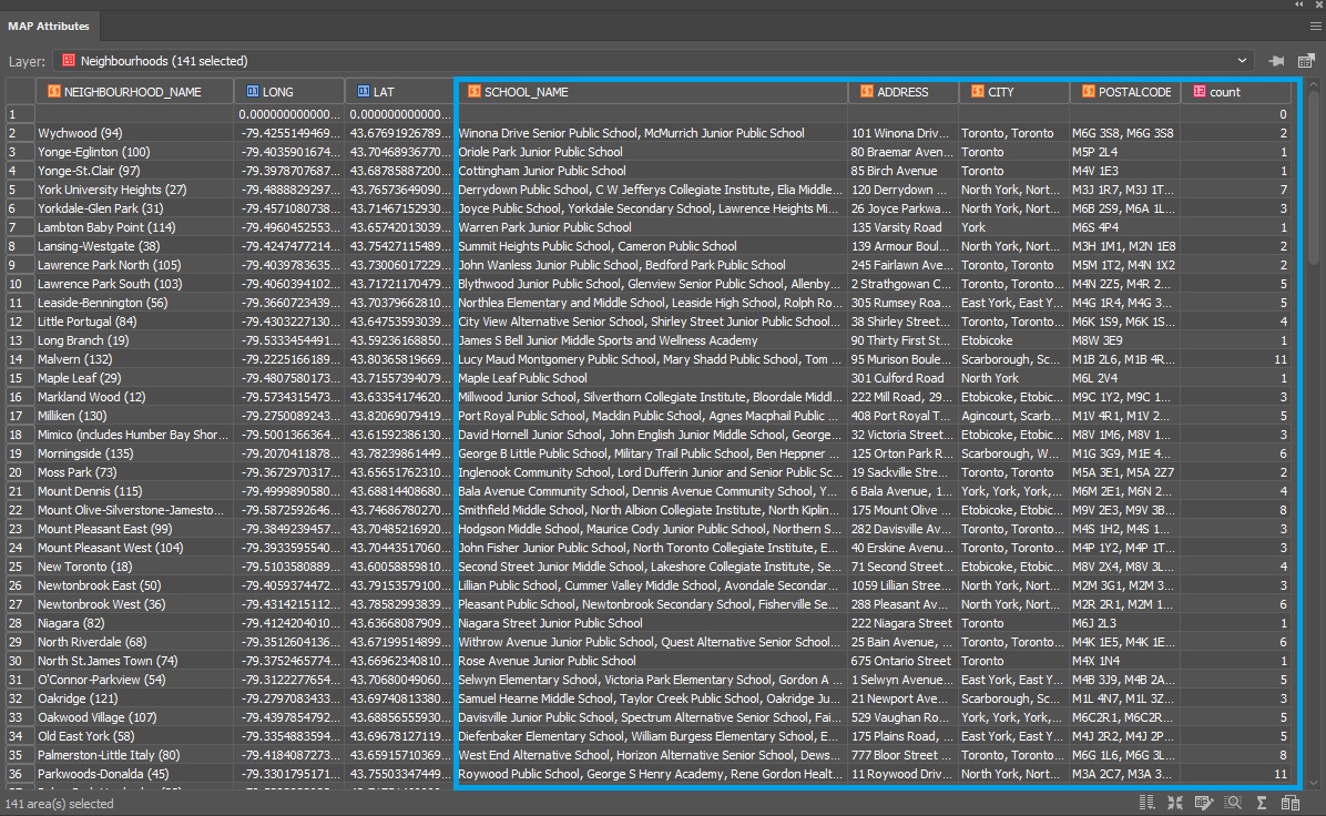
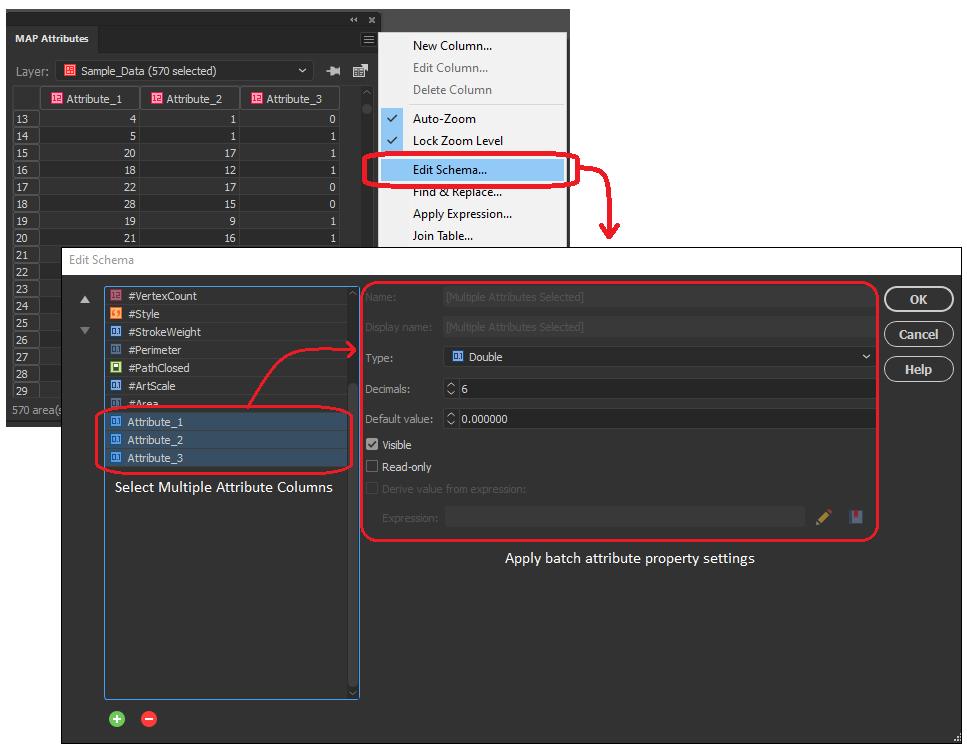
Multi-Column selections in the Attribute Table Editing Schema

In the early versions of MAPublisher 10, we added the ability to select multiple columns within the Edit Schema window of the MAP attributes panel, allowing users to toggle visibility settings on multiple attribute columns at the same time. Now with 10.8, we are delighted to build on this by implementing the ability to configure data properties across multiple selected attribute columns. Users can not only toggle visibility or remove multiple attribute columns at once, but can now also edit default values, attribute size, and read-only settings for all selected values. Additionally, users can now change the data type (i.e string, integer, boolean, etc) for multiple selected attribute columns all at once, as long as each column shares the same starting data type. 

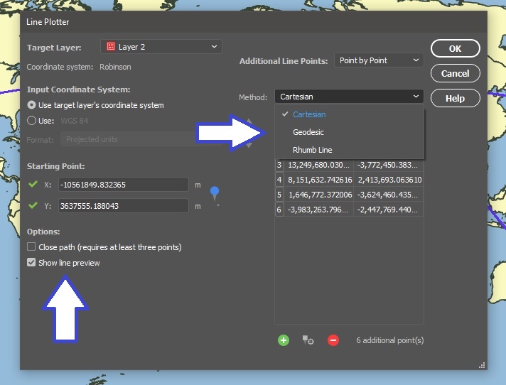
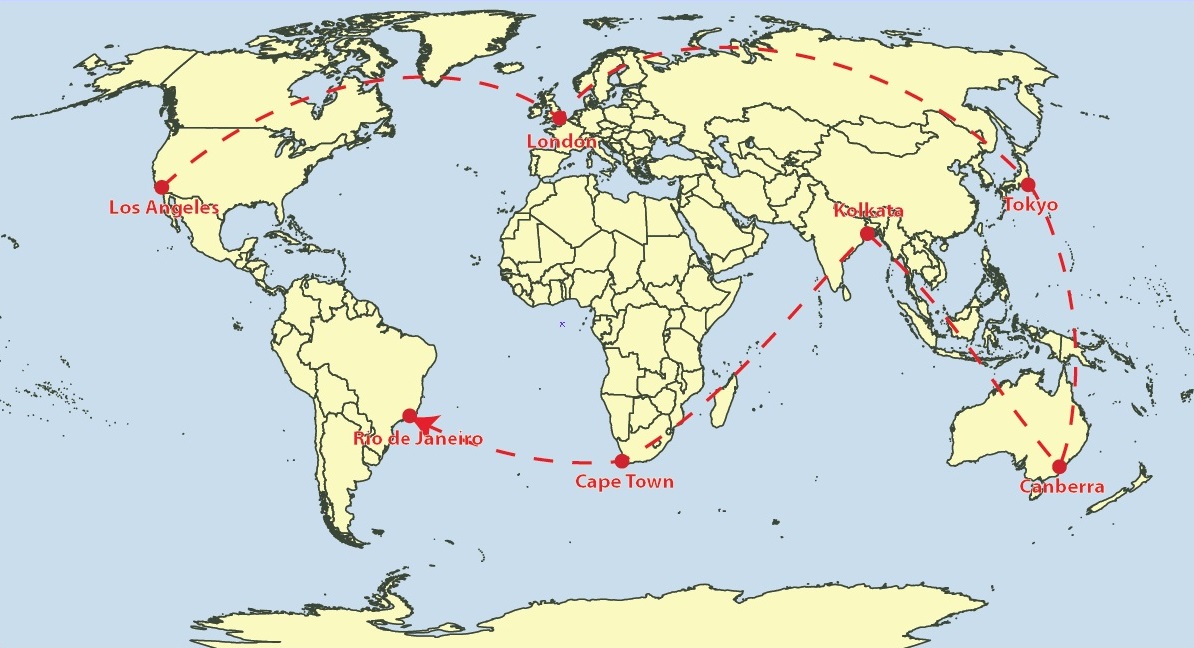
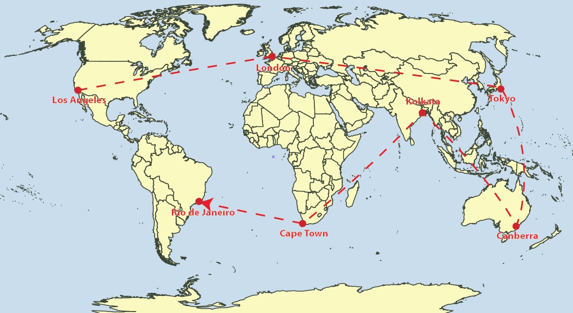
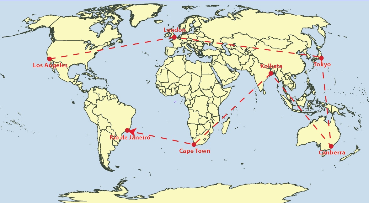
Select and add multiple MAP Locations in Line Plotter

We continue to bring improvements to the Line Plotter tool, this time by introducing the ability to select multiple MAP locations and add them to the line vertices (node) list. For users familiar with the Point-by-point plotting method in Line Plotter, this will be especially useful for adding a large collection of sequential MAP locations, as previously each point needed to be entered one at a time. 

Document Summary Panel now includes “Last Saved with” Version Info

For users working with MAPublisher projects across different versions of the software, you will be delighted to know that the document summary dialogue now includes information indicating the version of MAPublisher the project was last saved with. This information will help users that frequently share MAPublisher projects with colleagues, allowing them to better establish version standards across collaborative projects. 

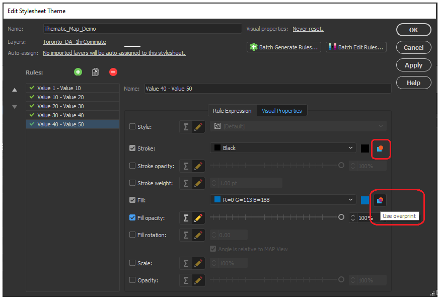
Overprint Options in MAP Themes

Previous versions of MAPublisher required a user to navigate the Illustrator attributes panel to configure overprint options for each map element individually and refer to these options separately using MAP Themes. Now with MAPublisher 10.8, an overprint option has been implemented directly within the MAP Themes panel, allowing users to configure overprint settings for fills and strokes within each stylesheet in the MAP Themes tool.

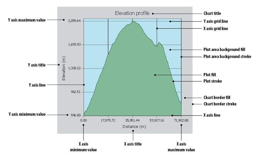
Scale bar, Create Legend, and Elevation Profile tool previews with Background Colours

We have added a small improvement to the scale bar, create legend, and elevation profile tool panel. The preview window for these tools, which allows users to adjust and edit their visual properties before adding them to the map, now has the option to configure a preview background colour. This option is helpful when configuring light, or white-coloured map elements which were previously difficult to see against the default white preview background. 

Support for Raster ECW file formats

New to MAPublisher 10.8, we now include Enhanced Compression Wavelet raster files to our growing lists of supported data formats. Users can now import and work with ECW files directly within the MAPublisher environment of Adobe Illustrator, all while retaining necessary spatial integrity, and without needing to convert your data. 

Engine Improvements and Updated Coordinate system catalogue

We are working continuously to improve the back-end MAPublisher engine to ensure our users can continue their work in an optimized, seamless,  design-focused cartographic environment. Along with improvements to our engine and bug fixes, we have built on our current coordinate system catalogue with updates to the coordinate system and projection library. This means our list of supported projections has grown, with new additions including the Natural Earth and Natural Earth 2 Projections created by Tom Patterson. For a full list of our expanded coordinate systems library please check the projections guide in the Avenza Support center.

MAPublisher 10.8 is immediately available today, free of charge to all current MAPublisher users with active maintenance subscriptions and as an upgrade for non-maintenance users. 

Find out more at the Avenza User Conference!

Want to learn more about MAPublisher? Want to see how industry professionals are using Avenza Products in their organizations? Join us on May 12th, 11am – 5pm (EST) for the first-ever Avenza User Conference. Registration is Free!

The event will feature a full day of speaker presentations from the Mapping and Geospatial communities. The Avenza Product teams will also be on hand to answer questions and give you a sneak peek of upcoming developments to the Avenza Platform. Sign up for free at avenza.com/user-conference

Avenza User Conference 2021


Avenza Releases MAPublisher 10.7 For Adobe Illustrator

Toronto, ON, December 14, 2020 – Avenza Systems Inc., producers of the Avenza Maps® app for mobile devices and geospatial plug-ins for Adobe Creative Cloud, including Geographic Imager® for Adobe Photoshop®, is pleased to announce the release of MAPublisher® 10.7 for Adobe Illustrator®.

This MAPublisher release improves on continued compatibility with Adobe Illustrator 2021 and macOS Big Sur. Product licensing improvements include a new Cloud floating license for easier setup for both admin and end-users. “Over the past several quarters, we have geared ourselves up for some major enhancements and have been working closely with our product partners at Adobe,” said Ted Florence, President of Avenza. “We’ve learned a lot and are continuously exploring more product features in the latest Adobe releases to bring them to our community of mapping professionals.”

Enhancements and new features of MAPublisher 10.7

  • Compatible with Adobe Illustrator 2021 on Mac and Windows
  • Compatible with macOS 11 Big Sur
  • Access Floating licenses from the Cloud
  • User interface and usability enhancements


MAPublisher 10.7 is immediately available free of charge to all current MAPublisher users with active maintenance and as an upgrade for non-maintenance users starting at US$599. New licenses are available from US$1399. MAPublisher FME Auto and MAPublisher LabelPro are also available as add-ons starting at US$399. Academic, floating, and volume licences are also available. Prices include one year of full maintenance. Visit www.avenza.com/mapublisher for more details.

More about Avenza Systems Inc.

Avenza Systems Inc. is an award-winning, privately held corporation that provides cartographers and GIS professionals with powerful software tools to make better maps. In addition to desktop mapping software, Avenza offers the mobile Avenza Maps app to sell, purchase, distribute, and use maps on iOS and Android devices. For more information, visit www.avenza.com.

For further information contact:  416-487-5116 – info@avenza.comwww.avenza.com

Avenza Releases Geographic Imager 6.2 for Adobe Photoshop

Toronto, ON, October 21, 2020 – Avenza Systems Inc., producers of the Avenza Maps® app for mobile devices and geospatial plugins for Adobe Creative Cloud®, including MAPublisher® for Adobe Illustrator®, is pleased to announce the release of Geographic Imager® 6.2. This latest version is powered by Adobe’s new Unified Extensibility Platform (UXP), which provides tremendous performance and user interface improvements to the Geographic Imager plugin for Adobe Photoshop.

“Geographic Imager has become a product many organizations trust and depend on to quickly edit and process spatial imagery,” said Ted Florence, President of Avenza Systems. “With increased performance and even more opportunities to develop new tools and experiences with UXP, the possibilities are endless.”

Powering the Geospatial Imagery Editing Process

Geographic Imager for Adobe Photoshop® delivers an all-encompassing solution to import, edit, and export geospatial images such as aerial and satellite imagery. Work with digital elevation models, GeoTIFFs, and other popular GIS image formats while using Adobe Photoshop® features such as transparencies, filters, cropping and image adjustments; all while maintaining georeferencing and support for hundreds of coordinate systems and projections.

New features of the Geographic Imager 6.2 plugin for Adobe Photoshop® include:

  • Compatibility: Fully compatible with Adobe Photoshop® 2021 on both Windows and Mac, powered by Adobe’s new Unified Extensibility Platform (UXP)
  • Exporting: Vector map data is now able to export to many industry geospatial formats
  • Advanced Importing: Ability to remove backgrounds from images during import


Geographic Imager is immediately available and free of charge to all current Geographic Imager Maintenance Program members and starts at US$319 for non-maintenance upgrades. New fixed licenses start at US$699. Geographic Imager Basic Edition licenses start at US$99. Academic, floating and volume license pricing is also available.
For more information, visit www.avenza.com/geographic-imager.

More about Avenza Systems Inc.

Avenza Systems Inc. is an award-winning, privately held corporation that provides cartographers and GIS professionals with powerful software tools to make better maps. In addition to desktop mapping software, Avenza offers the mobile Avenza Maps app to sell, purchase, distribute, and use maps on iOS and Android devices. For more information, visit www.avenza.com.

For further information contact: 416-487-5116 – info@avenza.com – www.avenza.com

What’s New in MAPublisher 10.6

Continued Compatibility with Adobe 2020

Both Windows (64-bit) and Mac users can explore the exciting new and improved features MAPublisher 10.6 offers with the latest version of Adobe Illustrator. Talk about a power duo — upgrade today (it’s free for maintenance users)!

Spatial Join

In our line of work, spatial relationships are really important and can be complicated, but working with them shouldn’t be. MAPublisher 10.6 delivers the brand-new Spatial Join feature and we’re ecstatic to be sharing it with you. With Spatial Join, you can:

  • copy attributes from one layer to another based on their spatial relationship
  • use relationships including Near, Closest, Identical To, Contains, Within, Has Centre In, and Intersects
  • adjust the Precision and Tolerance


Spatial Join Tool

Spatial Join Tool MAPublisher 10.6

Spatial Join tool

Spatial Join for MAPublisher 10.6

Features joined based on spatial relationship

Improved Line Plotter

The Earth isn’t flat, and your plotted lines shouldn’t be either! The improved Line Plotter tool will accurately plot lines with the Geodesic and Rhumb line methods, taking your projection into consideration (or calculation if we’re getting technical) and is available for both Point by Point and Course & Distance plotting styles.

The Rhumb line method will create either straight or curved lines, depending on the projection used. Still want to plot straight lines? The Cartesian method is sticking around and will work just as you remember it. A preview option is now available, so you can take a look at the three different methods on your map before plotting the line (or simply turn it off if your line has too many points).

Line Plotter Settings MAPublisher 10.6

geodesic_lineplotter MAPublisher 10.6

Geodesic Method: Shortest distance between points

Rhumbline Line Plotter MAPublisher 10.6

Rhumb lines: Constant bearing, curved or straight depending on the map projection.

cartesian_lineplotter MAPublisher 10.6

Cartesian lines: straight lines from destination to destination.

Improved Map Measurement Tool

linemeasurement Settings MAPublisher 10.6


With the addition of the Geodesic and Rhumb methods for plotting lines, we’ve made sure you can accurately measure the distance between points with these methods as well, whether they’re curved or straight lines.

  • Measure distances between points using Geodesic, Cartesian and Rhumb line methods
  • Like the Line Plotter, Geodesic and Rhumb measurement lines can be curved or straight, depending on the map projection
  • A combination of keyboard presses (Shift + Click) will add the measurement line as an object on your layer

Rhumbline Measurement MAPublisher 10.6

Rhumb Measurement Line

Geodesic Measurement Line MAPublisher 10.6

Geodesic measurement line

cartesian_measurement MAPublisher 10.6

Cartesian Measurement Line

Installer Will Uninstall Previous Versions

We’ve made some improvements to the installer. You’ll notice that the MAPublisher 10.6 installer will prompt you to uninstall previous versions of MAPublisher. We’ve designed the installer to guide you through this process. You can also uninstall older versions through the Control Panel (Windows) or as usually on macOS.

Export Document to Image

Colours on a map can make important information pop or sometimes they just make the map look nice. Whichever way, we’ve made sure your colour profiles stick around when exporting your document to an image. ICC profiles (the data that characterizes a coloured input or output device) will be embedded when documents are exported as TIFF files. If an Adobe Illustrator document is in the CMYK colour space, its colour profile will be embedded in the TIFF if the exported TIFF’s colour mode is also set to CMYK.

Map Data Links

We’ve made it easier to keep your workspace clean. Previously, when a layer is deleted, data links were not removed. In MAPublisher 10.6, data links are now removed when a layer is deleted and is the new default behaviour.

Stay safe out there and happy Spring cleaning!

MAPublisher 10.3 Released

We’re excited to announce the release of MAPublisher 10.3 for Adobe Illustrator. We’ve listened to your feedback and worked closely with our users to build features to improve map design and productivity. Stay tuned for more blog posts and other resources that go deeper into some of the new features. For now, here’s an overview:

MAPublisher 10.3

This update contains new features and performance improvements as well as fixes for reported issues. Some highlights are summarized below, for the full release notes see below.

Compatible with Adobe Illustrator CC 2019. We’re committed to providing the best GIS and cartography tools for building great quality maps in Adobe Illustrator. Improvements to our user interface to support high-resolution monitors, and this release is fully compatible with the latest Adobe Illustrator CC 2019 on both Windows (32-bit and 64-bit) and Mac.

Create Elevation Profile charts. An often-requested feature from our users, elevation data for points along a selected path can now be collected and displayed as an elevation profile in a highly customizable chart. The data is downloaded in real-time from a server (internet connection is required), which can then be customized to your liking using the available settings. Frequently used settings can even be saved for future use.

View data distribution when batch generating rules in MAP Themes and MAP LabelPro. When selecting a data classification in MAP Themes or MAP LabelPro, you now have the ability to see how it affects the data distribution in an interactive histogram and chart. Histograms are a great way to visualize continuous data in intervals and useful for large sets of data points.

Improved attribute capabilities in ‘Join’ tools. We have added many attribute management improvements to MAPublisher Join tools (Join Areas, Join Points, and Join Lines). You can now better manage how attributes are handled during a Join process, including the ability to calculate new attributes. We also added additional operations to help you better sort and calculate statistics from attributes.

MAPublisher 10.3 Release Notes

  • Compatible with Adobe Illustrator CC 2019
  • Create Elevation Profile charts
  • View data distribution when batch generating rules in MAP Themes and MAP LabelPro
  • Improved attribute capabilities in ‘Join’ tools
  • User interface and usability enhancements