


Get started with MAPublisher with online help including tutorials, knowledge base, and FAQs
Go to Support CentreArticles
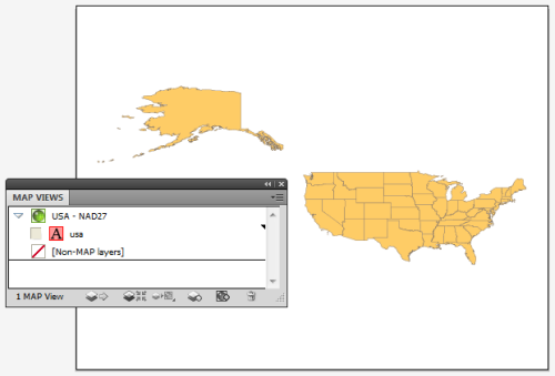
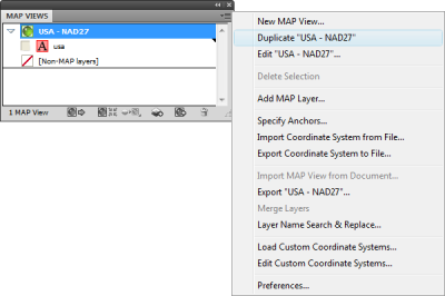
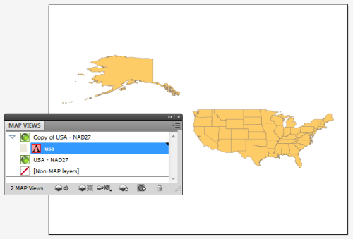
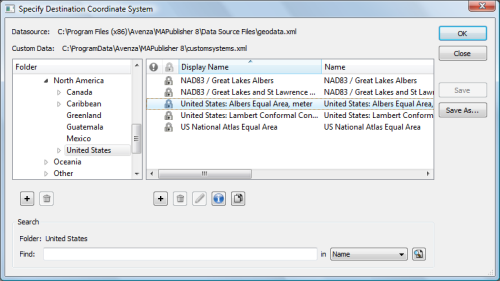
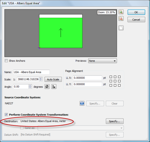
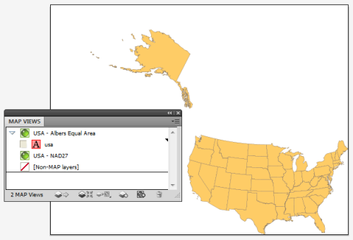
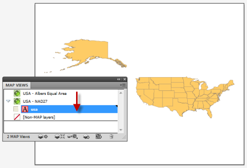
Learn from one of our MAPublisher product specialists at one of the many training courses we offer annually. Request a live online MAPublisher demo with us. We’re here to answer all your questions about it. MAP Views are designed to provide an easy method of accessing settings for specifying and transforming coordinate systems, for editing scale and data placement on the page and for exporting to GIS formats. The MAP Views panel allows for merging Adobe Illustrator layers, georeferencing existing Adobe Illustrator artwork, changing multiple layer names, and reprojecting data on the fly. That said, it’s possible to create multiple MAP Views that each contain a different projected coordinate system in a single map document. The MAP Views panel can be used to move Adobe Illustrator layers from one MAP View to another, enabling to reproject vector art quickly. Layers can be moved via drag-and-drop or with the new Switch MAP View button. This is useful when testing how a variety of projections may fit into your layout. It’s also useful for creating inset or key maps. Here we have one MAP View called USA – NAD27. As the name of it implies, it is in a NAD27 projection. Let’s go ahead and make another MAP View so that we can perform an easy transformation. Click the USA – NAD27 MAP View to highlight it, then click the panel option menu (upper right corner) and click Duplicate “USA – NAD27”. This creates a Copy of USA – NAD27 MAP View. Double-click the Copy of USA – NAD27 MAP View to edit it. In the MAP View editor, change the title to USA – Albers Equal Area in the Name box. Below you can see that it is currently in NAD27. Check the Perform Coordinate System Transformation check box and click Specify. In the Specify Coordinate System dialog box, in the Folder list, navigate to Projected > North America > United States and click United States: Albers Equal Area, meter in the right-hand pane. Click OK. Back in the MAP View editor box, you’ll see that the Destination is updated to show the United States: Albers Equal Area projection. Click OK. The map is reprojected from NAD27 to Albers Equal Area. To reproject-on-the-fly by drag-and-drop, click the usa area layer and just drag it to the USA – NAD27 MAP View. Now you can switch back and forth between projections. You may want to duplicate the usa area layer in the Layers panel so that you can have two different projections at the same time. Remember to use the MAP View editor if you want to move a MAP view to retain spatial referencing. To learn more about MAP Views, view Chapter 4 of the MAPublisher user guide. We seamlessly integrate MAPublisher and Geographic Imager panels and tools into Adobe Creative Cloud for a clean and intuitive mapping experience. We support more than 80 popular file formats used in GIS and mapping industries including SHP, GeoTIFF, KML, web services, spatial databases and more. From raw data to publishing high-quality maps—and everything in between—we combine powerful graphic design tools with geospatial accuracy and precision. Browse, preview, purchase and download professionally created, high-quality maps from the Avenza Map Store, including topographic, tourist, recreation maps, and more. Use the built-in GPS in your mobile device to locate yourself on any map (even works offline without network connectivity). Want to record where you’re at? Simply drop placemarks at your location. Navigating through a forest? Use the compass to orient yourself. Want to see how far you have walked, hiked, driven or biked? Record your activity using Record GPS Tracks and see exactly where you’ve been. View stats like elevation change and distance traveled on a graph including total time.
Get Training
Live Demo
Easy Transformations in MAPublisher
Seamless Integration into Adobe CC
Geospatial Interoperability
Cartographic Workflow
The Avenza Map Store
View your location using GPS
Record GPS Tracks