Are you using Adobe Creative Cloud 2015? Would you like to improve the performance of Adobe Illustrator? If so, participate in the Adobe Illustrator GPU performance beta program by registering here. Your participation will significantly help to improve the performance of Adobe Illustrator in the future.
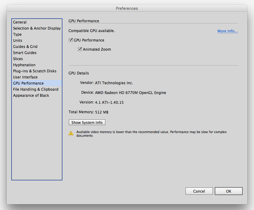
Adobe CC 2015 introduced a new feature in Illustrator Preferences and depending on the combination of the environment components, you might have already experienced that the performance can be really slow especially when making maps. We all know that many Illustrator files with cartographic projects can be very complex in terms of file size, layer/object structure, number of features, geometry, effects and tasks to every object applied. As a result, even if a supported GPU card is installed, the performance of Adobe Illustrator can be very slow.
We would like to introduce this beta program to you and our customers so that we can assist the Adobe Illustrator team to receive the customer feedback directly to help the development of the future version of Adobe Illustrator. If you could participate in this beta program, your voice will directly reach to the Adobe Illustrator team so that they can closely investigate to enhance the feature.
Adobe Illustrator CC 2015 Preferences: GPU Performance
If you or your organization have a floating license for MAPublisher or Geographic Imager, this blog post is for you. Having a floating license provides you with a lot of flexibility when you want to bring your laptop computer outside your work network and use MAPublisher and Georaphic Imager at home or in the field.
Let’s say you have a laptop computer and you want to work on your mapping project outside your office network. You can do it if your organization has a floating license.
Step 1: Make sure all the software is installed
On your laptop computer, make sure that you have MAPublisher for Adobe Illustrator or Geographic Imager for Adobe Photoshop installed and that there is a valid floating license (for one or each product).
Step 2: Connect your laptop to the network and to the licensing server
If you are not sure how to connect your laptop to the network and to the server, please contact your IT administrator. It is essential that your laptop computer is connected to the license server so that you can obtain a liecnse from it.
Step 3: Follow the steps in the MAPublisher/Geographic Imager license management window
Open the License Management dialog box.
If you’re using MAPublisher, access MAPublisher by going to Help > MAPublisher Licensing > License Management.
If you’re using Geographic Imager, access License Management by going to File > Automate > Geographic Imager: License Management.
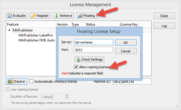
Click the Floating button to open the Floating License Setup dialog box.
Make sure that the “Allow roaming licenses” option is selected. Click OK.
Allow roaming licenses
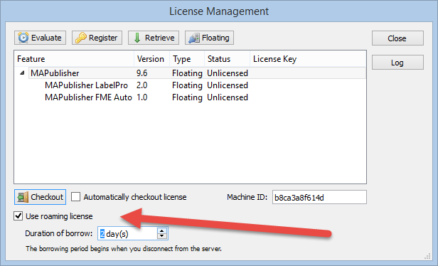
Click the “Use roaming license” option and specify the number of days in the Duration of borrow option. This indicates how long you want to use the license outside of your network.
Specify duration of borrow
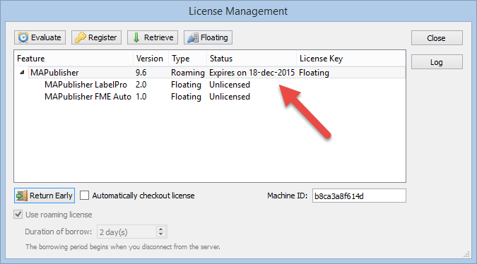
Clicking the “Checkout” button will change the status of the license. In this example, we borrowed a license from the license server for two days (December 16, 2015 starting date).
Checkout the license
Now you will be able to use your MAPublisher or Geographic license when your computer is disconnected from your work network. You might want to test it by closing Adobe Illustrator or Photoshop, disconnect your computer from the network, restart Adobe Illustrator or Photoshop, and see if you can use MAPublisher or Geographic Imager.
Having introduced some background information about text insertion point coordinate values in a previous post, it would be good to explore if this method works when trying to place text objects (annotations/labels) with a specific offset value. For example, if you have a point layer and there is an attribute for the offset value so that every object has a different offset value.
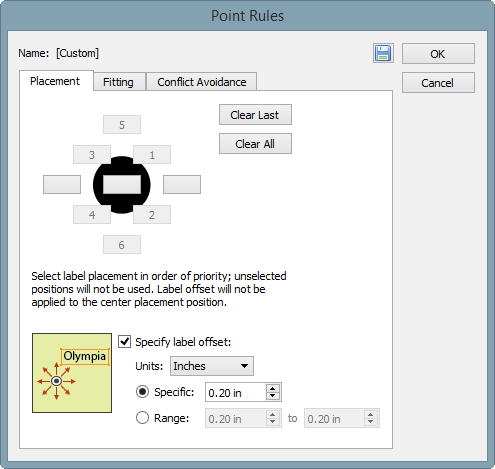
Placing text objects with a specific offset is possible in MAP LabelPro. You can specify the Label Offset value in the MAP LabelPro dialog box. However, this setting will be applied to all text labels. In the example below (see screenshot), all the text will be placed 0.2 inches away from the object. However, that does not help when every point has different offset value like this example. Also, MAP LabelPro uses page units, not the world/map units. In this example, the offset distance was specified in the world/map unit (metres).
There are two methods you can accomplish to make the text placed with offset value. The first method is the same as the step shown above. You can adjust the text placement position by calculating the “ideal” coordinate for the text insertion point. From a MAP layer (point, line, or area), generate text with a MAPublisher feature (MAP LabelPro or Feature Label). Then adjust the text position (maybe you will have to calculate a new position by adding/subtracting the offset values from the current point), then apply it to #MapX and #MapY. The second method is to adjust the position of the points first before labeling.
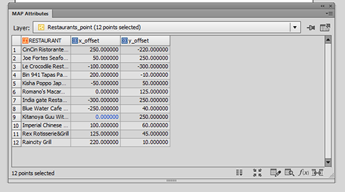
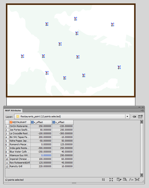
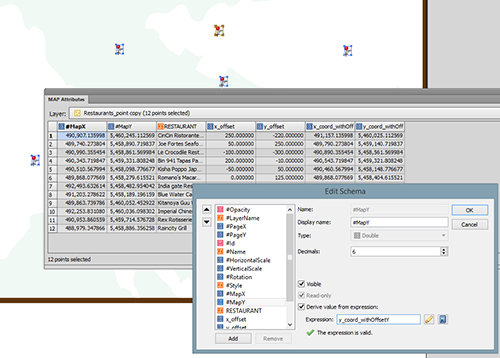
In the example below, a point layer with offset values in the attribute: x_Offset and y_Offset.
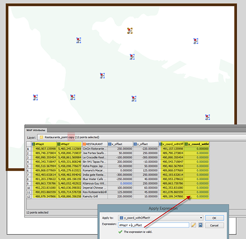
Step 1: Calculate coordinates with offset.
Create a copy of the layer just because the point value will be adjusted.
Make the #MapX and #MapY visible (so that it’s easy to see when calculating).
Create new columns (here we created “x+coord_withOffsetX” and “y+coord_withOffsetY”).
Calculate the new coordinate of the points for X and Y (here we used Apply Expression) as shown below.
Step 2: Move the points to the calculated coordinates with the offset values.
Use the same method as the one introduced in the previous post. This method works for the Point layer as well. Open the Edit Schema window and apply “x_coord_withOffset” and “y_coord_withOffset” to #MapX and #MapY, respectively.
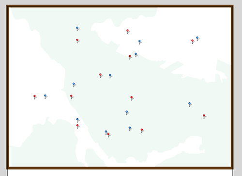
Now, the points are moved to new position. The red point is the original and the blue points are the ones moved to the offset. Now you can label each points. After placing labels for the point layer (blue), you can make the point layer invisible.
Now you can run the label engine (MAP LabelPro / Label Feature) for the new point layer with offset.
In this blog post we’ll look at how you can control the order of layers in MAPublisher when using FME Auto.
FME Auto to MAPublisher
FME currently doesn’t provide a way to explicitly define the output order of Feature Types in a workspace. In the Navigator you can reorder Readers and Writers to control the order in which they are run, but unfortunately you cannot do the same with the Feature Types they read and write respectively.
By default when you write layers to MAPublisher from FME using FME Auto, the layers are arranged first by geometry (text first, then Points, Lines, Polygons and lastly Images), then alphabetically by layer name. This behaviour can be changed by unchecking the FME Auto Parameter “Sort Layers by Geometry”. Once this has been turned off, MAPublisher will display layers in the order they are received from FME. Using this behaviour, some FME transformers and a Feature Type fanout (or new to 2015.1, specifying the Feature Type name) we can control the order of the layers in MAPublisher for optimal cartographic output.
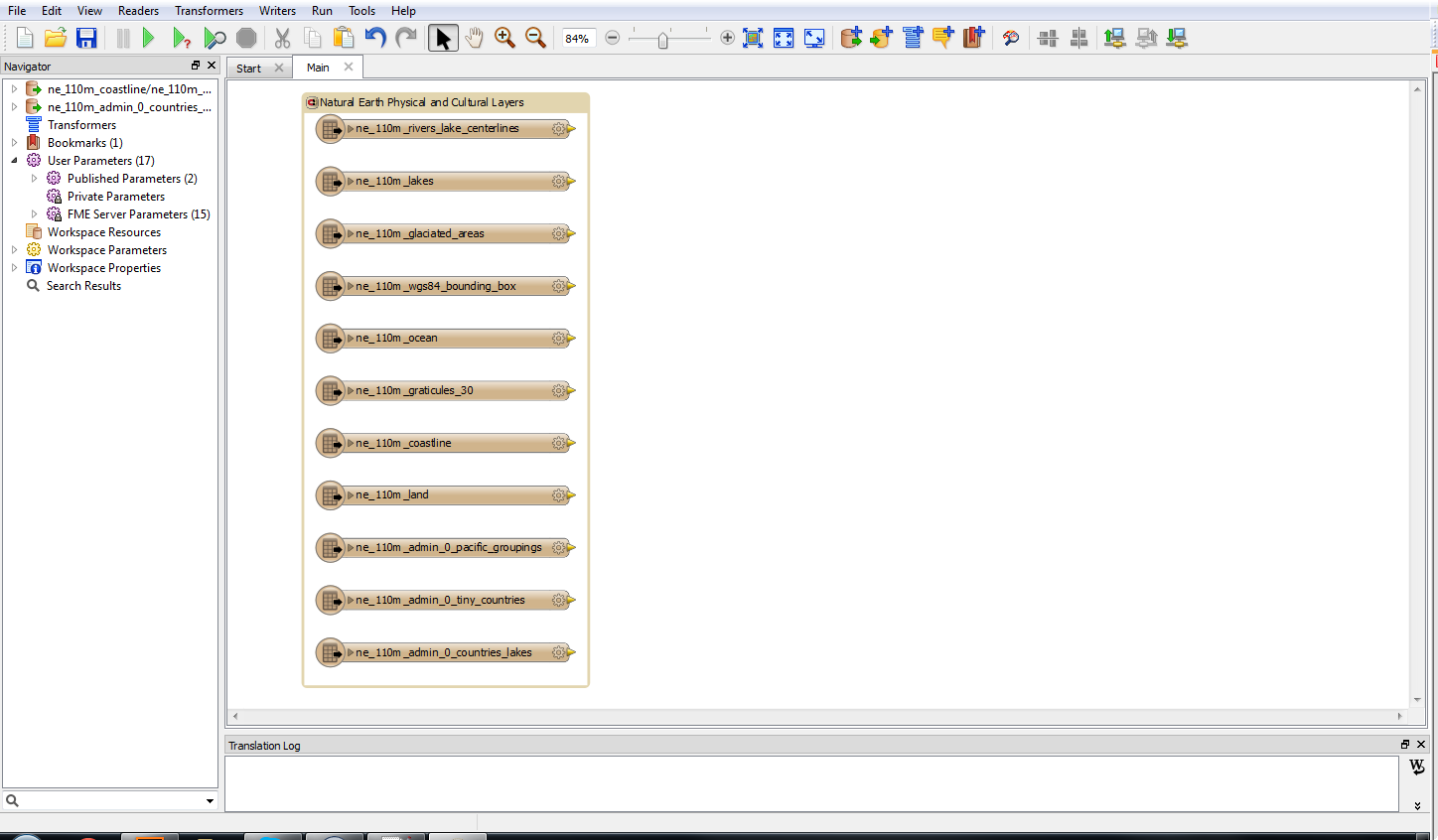
The first thing we want to do is to add some input Feature Types.
Natural Earth Shapefiles (Click for larger version)
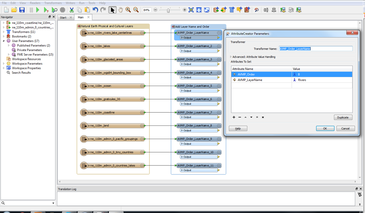
We will then create a template AttributeCreator Transformer to give each layer two attributes: MP_LayerName and MP_Order. MP_LayerName will define the name of the layer in MAPublisher and MP_Order will determine the order the layer is passed to MAPublisher; hence the order in which it is displayed.
AttributeCreator Transformer to add MAPublisher Specific attributes
Each Feature Type will be connected to a copy of the AttributeCreator Transformer and the values will be populated for that layer. The layer with an order of 1 will be on top with larger numbers descending below.
Layer Name
Order
Border
1
Graticules
2
Pacific Groupings
3
Tiny Countries
4
Coastline
5
Lakes
6
Countries
7
Rivers
8
Glaciated Areas
9
Land
10
Ocean
11
AttributeCreator Transformers connected to input Feature types (Click for larger version)
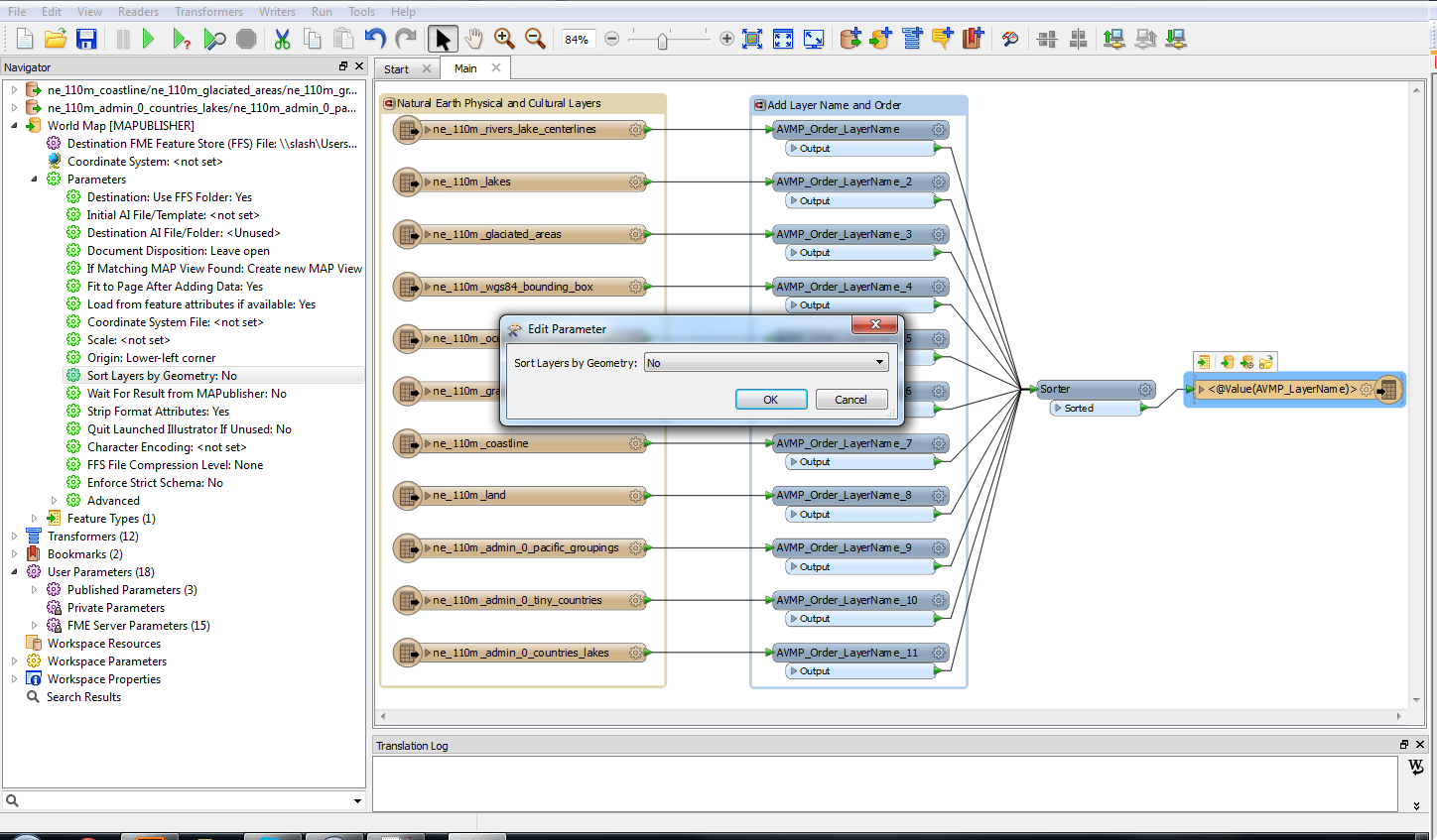
Once this is done, all the inputs can be connected to a Sorter Transformer. The Sorter will be set to numeric and ascending.
Sorter Transformer (Click for larger version)
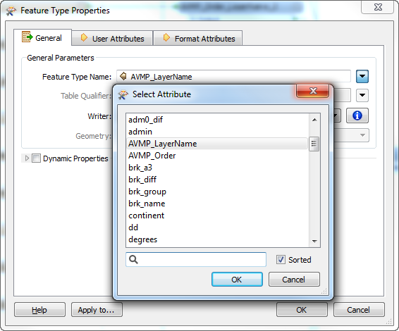
Finally, the MAPublisher writer is added. The Sort by Geometry parameter needs to be set to No and the Feature Type name should be set by the MP_LayerName attribute we created earlier. This replaces Feature Type fanouts and has slightly new behaviour at FME 2015.1. It is explained more fully (here).
MAPublisher writer added with Sort by Geometry Set to No (Click for larger version)Output Feature Types are defined by the LayerName attribute
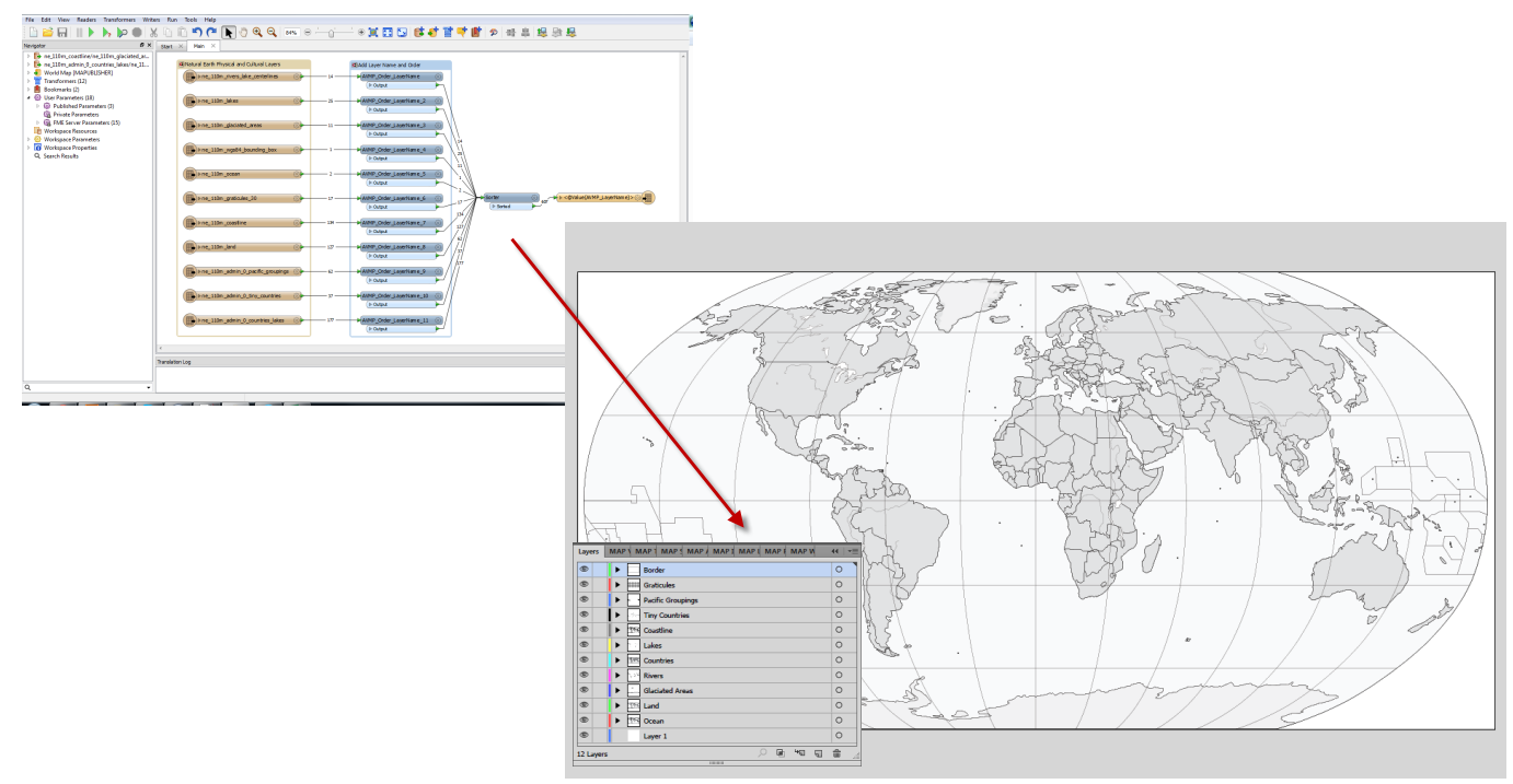
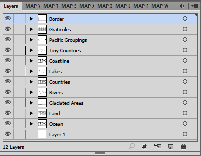
Once we run the workspace, we’ll see the layers in the Adobe Illustrator Layers panel in the exact order we specified.
Layers in Adobe Illustrator are in the correct orderThe final map after some cartographic styling (Click for larger version)
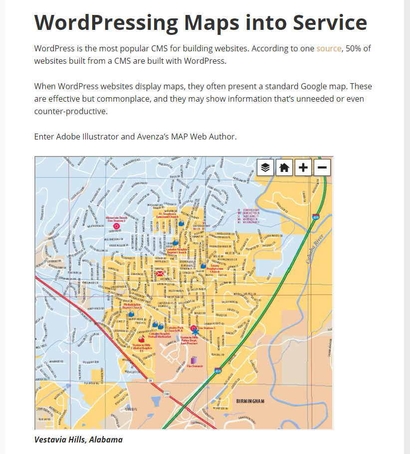
Our friends at Cartagram published a blog about adding MAPublisher Web Author maps into WordPress. Using this workflow, anybody can add custom maps to their WordPress blog.
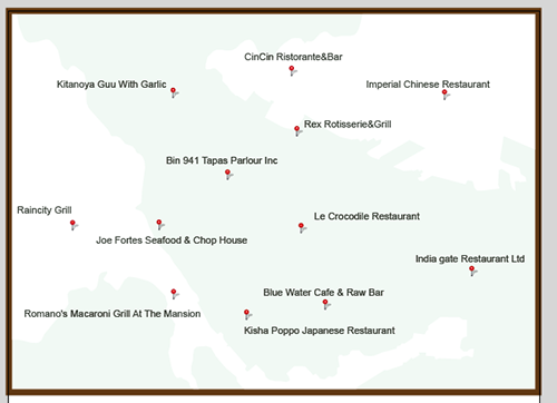
After a text placement engine places labels (e.g. annotations or labels) some manual adjustment is usually required. The major reason for this task is to avoid text colliding with other objects and to improve map aesthetics and composition. Here is an example map with the position of labels manually placed and adjusted. What do you usually do when updating your map and you have to update those labels?
An example with labels. The goal is to place the updated labels at the exact same position.
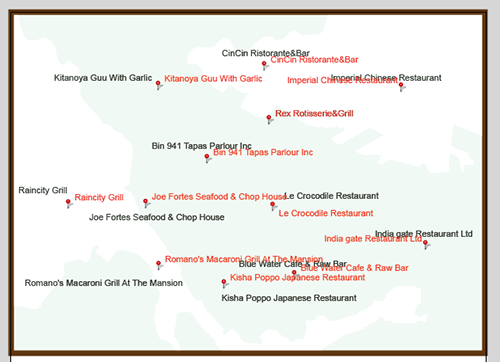
When running a text placement engine, it is common that the placed labels (in red) do not match with the position of the existing labels (in black). Have you ever thought that it would be useful if the updated labels can be positioned in the same place as existing labels? This is definitely possible using a combination of MAPublisher features.
A result after labels were placed with MAP LabelPro or Label Features.
Workflow involved to perform this task:
Obtain the position coordinate of existing text objects
Create new attributes to record #MapX and #MapY of each text object insertion point
Export the attribute table as a text file
Transfer the deteremined coordinte values of the text objects to the MAP layer (point layer in this example)
Join Tables using a common attribute between two tables
Place labels for the MAP layer
MAP LabelPro or Label Features
Adjust the position by those determined coordinate values for the text objects
Applying the recorded value to #MapX and #MapY
Step 1: Find the coordinates of the text insertion point from a text layer.
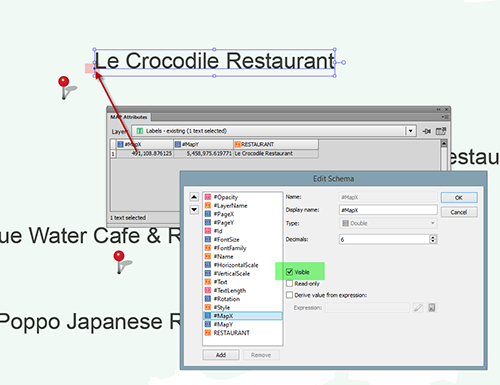
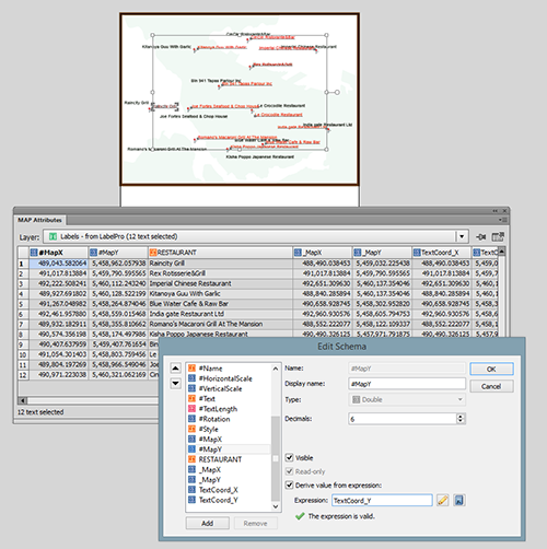
Every map object (point, line, area, image, and text) has a coordinate. MAPublisher calculates an insertion point when map objects are added to the artboard. For labels, a text insertion point can be seen as an anchor point or the square dot that is at the beginning of a text object. In this example, the text insertion point is placed at the lower-left corner of the word “Le Crocodile Restaurant” (highlighted in the red color in the screencapture below). The coordinate of this text insertion point is represented by the #MapX and #MapY attributes in the MAP Attribute panel. These two attributes are considered MAPublisher properties and are usually hidden. To display them, change their setting to “Visible” in the Edit Schema window as shown below.
Step 1: Finding the coordinate of the text insertion point from a “good existing text” layer
Step 2: Record the coordinates of the text insertion point from a text layer.
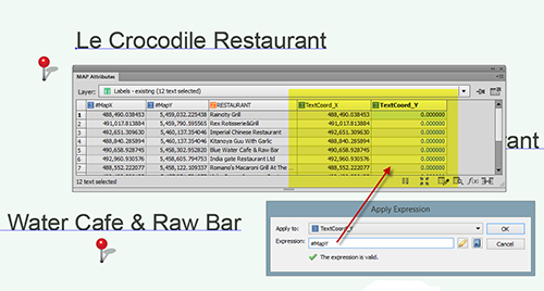
Make the #MapX and #MapY coordinate values as useable attributes. Create new attributes called “TextCoord_X” and “TextCoord_Y”, then copy the values from #MapX and #MapY using Apply Expression.
Step 2: Recording the coordinate of the text insertion point from a “good existing text” layer
Step 3: Prepare to copy coordinates of existing labels to the point layer.
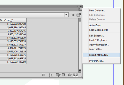
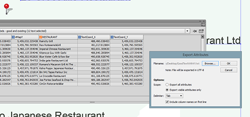
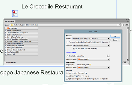
The coordinate values of the text insertion coordinate of a text layer are now copied. The next step is to copy these coordinates from the text layer to the point layer. A simple method to do this is to use Join Tables based on a common attribute. In this example, the string field “RESTAURANT” is the common field in both text and point layers to make a connection. If you already have some other attributes (i.e. object ID or feature ID in both the text layer and the point layer, you should use that). Export the attributes as a text layer from the MAPublisher Attributes panel options menu.
Step 3: Preparing for bringing the coordinates of good, existing labels to the point layer
Step 3: Preparing for bringing the coordinates of good, existing labels to the point layer (2)
Step 4: Join the Point layer to the exported attributes table.
Now, create a table join between the point layer table and the exported attribute table using the Join Table feature.
Step 4: Joining Tables with the exported Text layer and Point layer
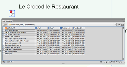
Below is the result from joining the tables together. There are also _MapX and _MapY columns because all visible attributes were exported. While the the step of copying attribute to TextCoord_X and TextCoord_Y was not totally be necessary, having columns named _MapX and _MapY could avoid some confusion because the point layer also has #MapX and #MapY columns. In this case, having attributes clearly indicating the values from the text insertion point is what is most important.
Step 4: Result from Join Tables
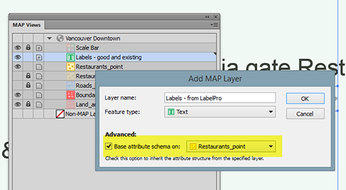
Step 5: Place labels with MAPublisher (inherit the attribute values from the point layer to text layer)
Now, place labels with MAPublisher using either Feature Label or MAP LabelPro. The important step here is to inherit the attributes from the point layer to the text layer (the target layer for generating new, updated labels).
When creating a new Text MAP layer, make sure that the “Base attribute schema on:” option is checked. This will allow the text layer to inherit the attributes from the point layer.
Step 5: creating a new MAP Text layer with the same attribute structure as the MAP Point Layer
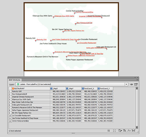
Below is the result of placing labels with MAP LabelPro (red labels). The result (in terms of the attribute structure) should be the same if labels are placed using Feature Labels. The position of new labels are not the same as the existing one. The label position can now be adjusted using the TextCoord_X and TextCoord_Y values.
Step 5: Labels placed with MAPublisher LabelPro or Label Features
Step 6: Move the text objects by adjusting the #MapX and #MapY.
As illustrated above, the text position is obtained from the text insertion point. The next step is to apply the text insertion point coordinates to the #MapX and #MapY attributes of the point layer using an expression with the Apply Expression feature or use the “Derive value from expression” option in the Edit Schema dialog box.
Apply the TextCoord_X and TextCoord_Y values to #MapX and #MapY, respectively.
Step 6: Now moving the text objects using the #MapX and #MapY
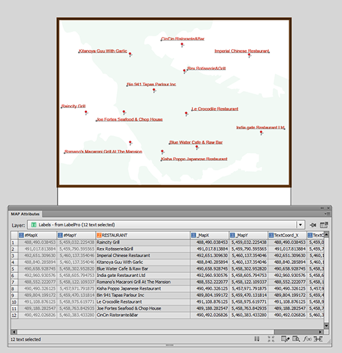
The labels are now positioned in the exact same location as the existing text layer.
Result: the new, updated labels are placed in the same position as the existing labels.
PDF Maps app to aid firefighting and emergency response efforts
TORONTO (October 27, 2015)—The United States Forest Service (USFS) fights wildfires and other natural disasters in more than 155 national forests and 20 national grasslands, totaling an estimated 193 million acres or 30% of all federally-managed lands. The USFS Geospatial Management Office (GMO) is responsible for the implementation of the Forest Service geospatial program which includes using technologies such as geographic information systems (GIS), remote sensing, cartography, geodesy, and global positioning systems (GPS).
Every year thousands of acres of forests are engulfed in fires. Recognizing the benefits of geospatial technology, the USFS GMO has included Avenza System Inc.’s award-winning PDF Maps mobile app in order to deliver interactive digital maps to fire fighters and emergency response teams situated in forests across the United States and its territories.
The centered blue GPS position on an operations map pinpoints the user’s location on Avenza’s PDF Maps app used on an iPad (Photo cred: Carl Beyerhelm)
With increased use of digital solutions, the USFS benefits from Avenza’s PDF Maps app geospatial technology in enabling its thousands of fire-fighters and support personnel. The PDF Maps app aids emergency response teams who use digital devices for work in the field. The PDF Maps app provides constant access to geographic information and points of interest, with additional interactive features such as measuring, place marking and location tagging. Avenza’s PDF Maps app operates without the risk of lost reception due to cell tower proximity and does not rely on an internet connection to use map data. It uses GPS to obtain and display an accurate position on the ground regardless of network connectivity.
“Accessing maps on mobile devices ensure responders have accurate and current geographic information while they’re out in the field,” said Carl Zulick, Geospatial Information Officer, USFS. “Avenza’s PDF Maps app makes it possible for teams to use any map digitally without requiring a data connection while involved in an emergency situation. Since the maps are location-aware and interactive, we can capture real-time data, photos, and locations. This data can be shared to assess the situation and make necessary strategic changes and improve situational awareness.”
The PDF Maps app is available now on the iTunes App Store and Google Play Store free of charge for personal recreational use. A Windows version is currently in public beta release. Commercial, government and academic use licensing is available for a nominal annual fee. For more information about PDF Maps, visit the Avenza website at https://avenza.com or the PDF Maps website at http://www.pdf-maps.com. Pricing of each map is set by the publisher and free maps remain free to users through the PDF Maps app in-app store. Commercial use licensing starts at US$49 per year and drops on a per-device basis as deployment numbers increase.
About Avenza Systems Inc.
Avenza Systems Inc. is an award-winning, privately held corporation that provides cartographers and GIS professionals with powerful software tools for making better maps as well as the PDF Maps mobile mapping system. In addition to software offerings for Mac and Windows users, Avenza offers value-added data sets, product training and consulting services. For more information, visit the Avenza website at www.avenza.com.
Contacts:
Christine Simmons
LFPR Public Relations – www.lfpr.com
(for Avenza Systems Inc.)
949-502-6200 ext. 320
christines@lfpr.com
PDF Maps app provides additional platform for a growing base of digital users to access more than 120,000 current and historic US Topo maps
TORONTO, ON, (September 1, 2015)— Providing science for a changing world, the United States Geological Survey (USGS) continues to support the delivery of its digital maps through Avenza Systems Inc.‘s popular, award-winning PDF Maps app. The wider selection of more than 120,000 US Topo maps on a popular digital mapping platform provides digital users access to USGS’ rich map content, and extends its reach with a growing base of mobile consumers.
With the digital map user base continuing to rise year after year, USGS map users benefit from Avenza’s PDF Maps app geospatial technology. The app currently aids a growing number of people who reference digital devices for work or recreation. Travelers, recreationists, scientists and conservation and environmental decision makers already make use of USGS topo maps but the expanded use of the maps via the PDF Maps app provides current USGS topo map users the ability to digitally access maps in areas with little to no internet reception and input notes and images within the map all while tracking current position.
The USGS produces Topo maps on a continuous basis with more than 18,000 revised quadrangles produced every year. Currently, thousands of maps from USGS’s extensive library are now available in Avenza’s PDF Maps database including the most current variations that reflect the changing landscape of the country. Many historical maps can also be accessed with thousands more dating back 130 years being added in the near future. The app provides constant access to geographic information and points of interest, with additional interactive features such as measuring, place marking and location tagging. Avenza’s PDF Maps app operates without the risk of lost reception due to cell tower proximity, making it the ultimate traveling tool since it does not rely on an internet connection to use map data and obtain and display location.
“Distinguished map publishers like the USGS fully recognize the shift to digital and how consumers are accessing and consuming information that was once static and digitally implementing it into their daily lives and making it more interactive,” said Ted Florence, president of Avenza Systems Inc. “Avenza’s PDF Maps app is an example of how a digital tool can expand the utility of a map beyond location guidance; it is also a tool to capture an experience in real-time. As the industry continues to evolve to fit into the world of a mobile consumer, we look forward to strengthening our ties with groups like the USGS.
PDF Maps app 2.6 is available now on the iTunes App Store free of charge for personal and private use. PDF Maps app is also available for use with Android devices in the Google Play Store free of charge for personal non-commercial use. A Windows version is currently in public beta targeted for a release later this year. Commercial, government and academic use licensing is available for a nominal annual fee. For more information about PDF Maps, visit the Avenza website at https://avenza.com or the PDF Maps website at http://www.pdf-maps.com. Pricing of each map is set by the publisher and free maps remain free to users through the PDF Maps app in-app store.
Avenza Systems Inc. is an award-winning, privately held corporation that provides cartographers and GIS professionals with powerful software tools for making better maps as well as the PDF Maps mobile mapping system. In addition to software offerings for Mac and Windows users, Avenza offers value-added data sets, product training and consulting services. For more information, visit the Avenza website at www.avenza.com.
Contacts:
Christine Simmons
LFPR Public Relations
www.lfpr.com
(for Avenza Systems Inc.)
949-502-6200 ext. 320
PDF Maps 2.6 for iOS Provides Consumers More Purchasing Choices With Map Bundles Including New York-New Jersey Trail Conference
TORONTO, ON (August 25, 2015)— Avenza Systems Inc., the leading developer of cartographic software — such as MAPublisher for Adobe Illustrator and Geographic Imager geospatial tools for Adobe Photoshop — announced the latest version of PDF Maps 2.6 for iOS devices. This release introduces Map Bundles available for purchase in the PDF Maps Store. Map publishers can now group multiple maps together to create map bundles and offer them for sale, giving consumers more purchasing options, an opportunity to save money, and an improved shopping experience.
The PDF Maps app takes advantage of geospatial technology that allows travelers to view and measure real world locations and attributes. Paired together with mobile devices that utilize GPS, such as an iPhone, the PDF Maps app provides constant access to geographic locations and even points of interest without the risk of losing reception due to cell tower proximity. This makes it the ultimate travel accessory for any activity in areas where internet bandwidth is not available or while roaming outside one’s data zone. Key features and capabilities of PDF Maps 2.6 include:
Introducing Map Bundles in the PDF Maps Store, download and purchase collections of maps
Improved OpenStreetMap search results
Option to disable placemark aggregation
German, Russian, Japanese and Chinese localization
New online help available through Settings
Line units are now uniform and will display in the current units in the Measure tool as opposed to being set individually
Data recorded on maps without georeferencing is no longer supported as a result of major database changes. Export data prior to upgrading to save recorded data.
“As a company that strives to help our industry evolve and grow in a digital environment, we’re listening to our map publisher’s requests and have created map bundles to provide them with additional sales opportunities. This also reaffirms our commitment to make it easy for consumers to obtain maps,” said Ted Florence, president, Avenza Systems Inc. “We’re excited to see the continued growth of PDF Maps, not just as a product, but as a valuable tool that aids consumers in exploring the world as well as helps commercial users solve problems. We hope the latest features of PDF Maps 2.6 help make a difference.”
“The availability of New York-New Jersey Trail Conference maps in the PDF Maps Store has continued to provide an additional platform that consumers can easily access digitally while providing an interactive way to experience our rich content, especially with the latest version of PDF Maps,” said Jeremy Apgar, cartographer, New York-New Jersey Trail Conference. “Map bundles are an excellent way to purchase multiple maps and provide a tremendous value. We’re excited that we can continue to provide accurate and detailed maps to PDF Maps app users.”
Currently, Avenza’s vast PDF Maps app library covering maps for domestic and international destinations includes more than 100,000 maps organized by country, state and area. All maps available through the in-app iTunes-like map store offer the following capabilities:
Access and load maps through in-app purchase, iTunes File Sharing, Wi-Fi or cellular network to read maps anytime
Access and interact with saved maps without the need for a live network connection (offline)
View your location on the PDF map using the built-in GPS device or via Wi-Fi triangulation
Find coordinates of any location in the map, including the ability to type in coordinates to search
Display coordinates as Lat/Long (WGS84), Lat/Long (Map Default), Northing/Easting, or Military Grid Reference System (MGRS/United States National Grid (USNG)
Support for GeoTIFF files to create tiles similar to how a geospatial PDF is tiled
Map rendering in higher resolution
Overlay Google search results
Add waypoints and collect/record information about locations, including photos
Measure distances and areas
Open current map extents in the Maps app
Quickly view, zoom and pan maps using gestures (pinch, drag and flick, double tap)
Change pin colors, position and label names
PDF Maps app 2.6 is available now on the iTunes App Store free of charge for personal and private use. PDF Maps app is also available for use with Android devices in the Google Play Store free of charge for personal non-commercial use. A Windows version is currently in public beta. Commercial, government and academic use licensing is available for a nominal annual fee. For more information about PDF Maps, visit the Avenza website at www.avenza.com or the PDF Maps website at www.pdf-maps.com. Pricing of each map is set by the publisher and free maps remain free to users through the PDF Maps app in-app store.
About Avenza Systems Inc.
Avenza Systems Inc. is an award-winning, privately held corporation that provides cartographers and GIS professionals with powerful software tools for making better maps as well as the PDF Maps mobile mapping system. In addition to software offerings for Mac and Windows users, Avenza offers value-added data sets, product training and consulting services. For more information, visit the Avenza website at www.avenza.com.
– Cartographic add-on now compatible with Adobe Illustrator Creative Cloud™ 2015 –
Toronto, ON, August 6, 2015 – Avenza Systems Inc., producers of the PDF Maps app for mobile devices and geospatial plug-ins for Adobe Creative Cloud, including Geographic Imager® for Adobe Photoshop®, is pleased to announce the release of MAPublisher 9.6 for Adobe Illustrator. This latest update includes many new features and is fully compatible with the recently released Adobe Illustrator Creative Cloud 2015. This release also introduces map package export compatible with the PDF Maps mobile app and the upload of map packages directly to the PDF Maps digital map store.
“We’re delighted to release MAPublisher 9.6 to ensure our users are using the latest map making tools with the newest features of Adobe Illustrator Creative Cloud 2015,” said Ted Florence, President of Avenza. “An important addition to an already full-featured cartographic tool lineup is the ability to create map packages for the PDF Maps app,” he added. “These map packages can be loaded directly into the app by anybody wanting to use custom maps. Map publishers can easily upload map packages directly to the map store from Adobe Illustrator, making it easier to publish and sell maps, and has become a complete platform that benefits both map users and makers alike.”
Enhancements and new features of MAPublisher 9.6
Fully compatible with Adobe Illustrator Creative Cloud 2015 on both Windows (32-bit and 64-bit) and Mac
New ability to export a map package compatible with the PDF Maps app. Map publishers can upload map packages directly to the PDF Maps Store
Optimized Export Document to Web Tiles for faster tile export
New text utility that curves text to lines of latitude
Compatible with FME Desktop 2015 for MAPublisher FME Auto
Various user interface and performance enhancements to improve usability
More about MAPublisher for Adobe Illustrator
MAPublisher for Adobe Illustrator is powerful map production software for creating high-quality maps from GIS data. MAPublisher cartographic tools leverage the superior graphic design capabilities of Adobe Illustrator to manipulate GIS data and to produce both print-ready and online maps with accuracy and efficiency.
MAPublisher 9.6 is available free of charge to all MAPublisher users with an active maintenance subscription and as an upgrade for non-maintenance users at US$599. New commercial licenses are US$1399. MAPublisher FME Auto and MAPublisher LabelPro are also available as add-ons to MAPublisher 9.6 at prices starting at US$399 per license. Academic, floating and volume pricing are also available. Prices include one year of full maintenance. Visit www.avenza.com/mapublisher for more details.
More about Avenza Systems Inc.
Avenza Systems Inc. is an award-winning, privately held corporation that provides cartographers and GIS professionals with powerful software tools to make better maps. In addition to software offerings for Mac and Windows users, Avenza offers value-added data sets, product training and consulting services, as well as the PDF Maps app for purchasing and using maps on iPhones, iPads and iPod Touch devices. Visit www.avenza.com for more details.
For further information contact:
Tel: 416-487-5116
Email: info@avenza.com
Web: www.avenza.com