My Account     Contact Us     Cart

Accurate Georeferencing with Geographic Imager

Georeferencing is the process of adding spatial information to a physical map or raster image. Geographic Imager includes a georeferencing tool and also includes two methods of validating georeferencing so that your imagery is not only beautiful but also spatially aware (that’s two of the four keys to great maps!).

Use the Georeference feature in Geographic Imager to reference an image by establishing ground control points, choosing a transformation method, and specifying a coordinate system. It can also be used to rectify—transform or warp—an image to match the image coordinate system specified. The Validate and Show Image Extents Online tools are used to test georeferencing accuracy.

Geographic Imager - validating georeferencing accuracy

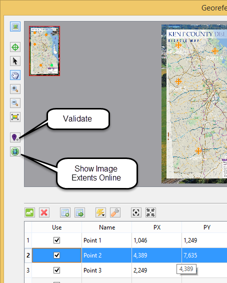
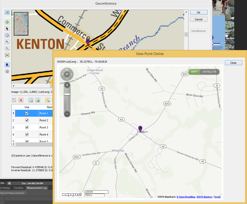
The Validate tool provides a visual comparison of the accuracy of your image to the real world. Use the Validate tool by clicking a point on the image to see the corresponding location on a web map.

The image below shows the Validate tool in action. Select the tool and click on a road intersection to open the web map with the same intersection identified. If the two don’t match, consider georeferencing again. It is good practice to test several known points on the image to ensure overall accuracy. Choose features that will be easy to identify on the web map such as road intersections, coastlines, buildings, and landmarks.


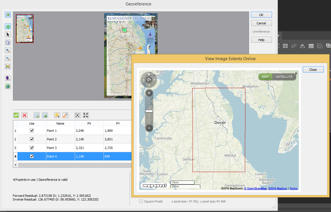
The Show Image Extents Online tool displays a rectangle representing the spatial extent of the image on the web map. Use this tool to verify that the full area covered by the image is accurate. Note that the rectangle shown on the web map will include the non-map areas of the image including the borders, legend, etc.


Geographic Imager - Show Image Extents


It’s that simple! Using Geographic Imager, you can manipulate imagery in Adobe Photoshop while now ensuring spatial integrity!


Blog Archive

March 2024 (2)
February 2024 (1)
January 2024 (1)
December 2023 (1)
November 2023 (2)
October 2023 (2)
September 2023 (1)
August 2023 (1)
July 2023 (3)
June 2023 (1)
February 2023 (1)
January 2023 (2)
December 2022 (1)
November 2022 (2)
October 2022 (2)
September 2022 (1)
May 2023 (1)
August 2022 (3)
July 2022 (1)
June 2022 (2)
May 2022 (1)
February 2022 (1)
January 2022 (2)
December 2021 (3)
November 2021 (5)
October 2021 (1)
September 2021 (3)
August 2021 (2)
July 2021 (1)
June 2021 (2)
May 2021 (2)
April 2021 (3)
March 2021 (3)
February 2021 (2)
January 2021 (1)
November 2020 (1)
October 2020 (1)
June 2020 (2)
May 2020 (1)
April 2020 (3)
March 2020 (2)
December 2019 (1)
November 2019 (2)
September 2019 (1)
August 2019 (1)
July 2019 (1)
June 2019 (3)
May 2019 (4)
April 2019 (2)
March 2019 (1)
February 2019 (2)
January 2019 (3)
December 2018 (2)
November 2018 (1)
October 2018 (1)
September 2018 (2)
August 2018 (4)
July 2018 (2)
June 2018 (1)
July 2018 (1)
June 2018 (4)
May 2018 (1)
April 2018 (2)
March 2018 (5)
February 2018 (1)
January 2018 (1)
November 2017 (1)
October 2017 (2)
August 2017 (2)
July 2017 (1)
March 2017 (1)
February 2017 (2)
January 2017 (2)
November 2016 (1)
January 2017 (1)
November 2016 (1)
October 2016 (2)
May 2016 (1)
April 2016 (2)
December 2015 (2)
June 2015 (1)
May 2015 (1)
April 2015 (2)
December 2014 (4)
October 2014 (2)
May 2014 (4)
February 2014 (1)
October 2013 (3)
April 2013 (1)
January 2013 (2)
August 2012 (1)
October 2012 (1)
July 2012 (3)
May 2012 (2)
January 2012 (2)
August 2011 (1)
July 2011 (2)
June 2011 (2)
May 2011 (2)
March 2011 (1)
February 2011 (1)
January 2011 (5)
December 2010 (1)
November 2010 (1)
December 2010 (1)
November 2010 (1)
October 2010 (1)
August 2010 (4)
July 2010 (2)
June 2010 (3)
May 2010 (2)
April 2010 (2)
March 2010 (2)

Search