


We are excited to announce the release of Geographic Imager version 7.0, the latest version of our Geographic Imager extension for Adobe Photoshop.
With Geographic Imager 7.0, we are introducing several updates to the Terrain Shader tool, including a new relief option called texture shading, 11 new colour maps, and a toggle button for the relief preview, as well as other performance enhancements and bug fixes.
Here’s what you can expect with the latest Geographic Imager 7.0 release:
Terrain Shader improvements
Texture Shading
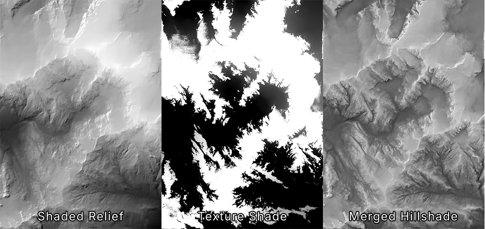
With this Geographic Imager release comes many improvements to the Terrain Shader, starting with a new relief option called texture shading. This option utilizes an algorithm developed by Leland Brown to generate a texture shade, which offers a more natural representation of terrain than a standard shaded relief with a single light source. While a texture shade is more successful at depicting the subtle differences in terrain, it is not the type of terrain we are used to seeing on maps—especially when there is a high contrast between the dark valleys and light ridges of a particular DEM. This can be mitigated by merging a texture shade with a shaded relief to achieve a hillshade that combines the best of both worlds!
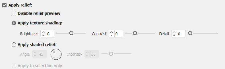
Using the Terrain Shader with “Apply relief” enabled, you can now choose to apply texture shading or shaded relief to your DEM. The texture shading option allows you to control the brightness, contrast, and detail of your texture shade to ensure that you can finetune the visualization of your map’s hillshade. After outputting your texture shade, you can merge this image with your shaded relief image in Photoshop to create the ideal custom hillshade for your map.
New colour maps
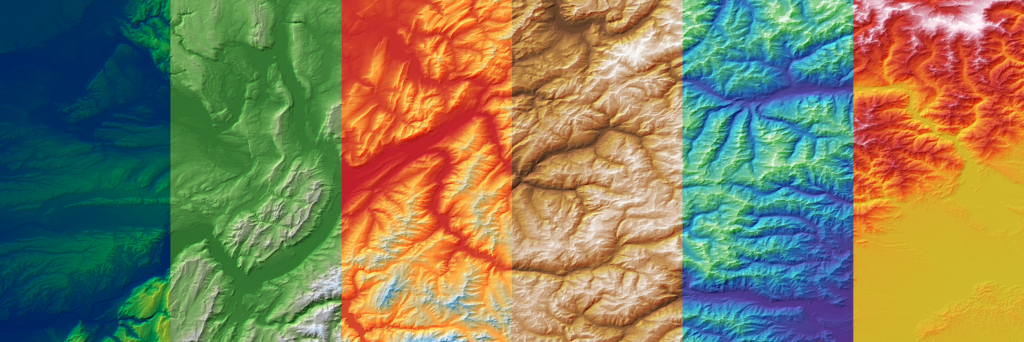
Geographic Imager 7.0 introduces a complete overhaul of the default colour maps available in Terrain Shader, with eleven brand new colour maps to choose from! The new gradients feature more practical colourization and were designed with usability in mind. Whether you are looking for a more natural-looking colour map or something a little more artificial or scientific, these new defaults have you covered. As always, the default colour maps are 100% editable to ensure you can create something that suits your map’s aesthetic!
Disable relief preview toggle
Terrain Shader also now features a “Disable relief preview” checkbox, which allows you to toggle the relief preview on and off as needed. This is a small but useful tool when working with large DEMs, which can slow down the software when generating previews for reliefs. This button is located under the “Apply relief” checkbox.
Geographic Imager 7.0 is Available Now!
If you want to learn more about the new Geographic Imager 7.0 features or have any questions, please check out our Support Centre.
Geographic Imager 7.0 is available immediately, free of charge, to all current Geographic Imager users with active maintenance subscriptions and as an upgrade for non-maintenance users.